Mugii Murum-ban State Conservation Area

Last updated

Mugii Murum-ban State Conservation Area
New South Wales
Mugii Murum-ban SCA 09 - by Anton Leddin.jpg
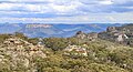
Genowlan Plateau viewed from Genowlan Point
Australia New South Wales relief location map.png
Red pog.svg
Mugii Murum-ban State Conservation Area
Nearest town or city Capertee
Coordinates 33°07′S150°04′E / 33.11°S 150.07°E / -33.11; 150.07
Established2011
Area36.5 km2 (14.1 sq mi) [1]
Managing authorities NSW National Parks & Wildlife Service
Website Mugii Murum-ban State Conservation Area

Mugii Murum-ban State Conservation Area is north of Lithgow, north-east of Capertee and south-east of Mudgee.

Contents

The park is 3,650 hectares in area and is bounded to the south by the Glen Davis Road and Gardens of Stone National Park, and to the north by Capertee National Park. Land to the east and west is largely cleared farming land, with some remnant bushland. Lands not included in the park include Airly Gap Trail and a number of partially cleared private properties along Airly Gap Trail and at the base of the Genowlan mesa.

The park contains a variety of ecosystems and supports several threatened plants and animals and two threatened ecological communities. The park also contains mineral deposits including deposits of coal.

History

Mugii Murum-ban is the Wiradjuri name of Charlie Riley. Mugii means 'a mopoke owl' and murum-ban means ‘eldest son’.

The area is of particular significance to the Wiradjuri Aboriginal People. It also contains numerous significant historic heritage sites particularly mining related.

Geology

Mugii Murum-ban State Conservation Area is dominated by two prominent mesas, Genowlan and Airly Mountains, that rise 500 metres from the Capertee Valley. The area is one of dramatic valleys and canyons surrounded by cliffs and rock formations known as pagodas.

Genowlan Mesa

The Genowlan mesa is topped by hundreds of 'pagoda' rock formations. Notable formations include the 'Citadel', the 'Valley of the Kings', and the 'Grotto' with 20 metre tall Brown Barrel eucalypt trees and four metre tall tree ferns. Over 340 plant and 75 mammal and bird species can be found. Small areas of basalt on top of the sandstone add to the diversity. The narrow sandstone headland of Genowlan Point is home to a unique and relict plant community which comprises Johnson's Grass Tree, Allocasuarina nana and Micromyrtus sessilis.

Mount Airly

Mount Airly lies to the west of Genowlan Mountain and is separated from it by Airly Gap. The underlying oil shale deposits were developed for oil export by individual miners in 1893. Extraction occurred on the slopes of Airly Gap and also on the western side of Mount Airly. The New Hartley 'ghost town' near Airly Gap has remnants of tunnels, cableways, shale oil retorts, steam engines, dwellings, 'stone houses, transportation and mine ventilation chimneys. The ruins are on the New South Wales Heritage List. The northern and western edges of Mount Airly feature dramatic pagodas.

Related Research Articles

<span class="mw-page-title-main">Gardens of Stone National Park</span> Protected area in New South Wales, Australia

The Gardens of Stone National Park is a protected national park that is located in the Central Tablelands region of New South Wales in eastern Australia. The 15,080-hectare (37,300-acre) national park is situated 125 kilometres (78 mi) northwest of Sydney, and 30 kilometres (19 mi) northwest of Lithgow. The national park draws its name from the natural stone pagodas within its boundaries.

<span class="mw-page-title-main">Kanangra-Boyd National Park</span> Protected area in New South Wales, Australia

The Kanangra-Boyd National Park is a protected national park that is located in the Central Tablelands region, west of the Southern Highlands and Macarthur regions, in New South Wales, in eastern Australia. The 68,660-hectare (169,700-acre) national park is situated approximately 180 kilometres (110 mi) south-west of Sydney and is contiguous with the Blue Mountains National Park and the Nattai National Park. The park was established in 1969.

<span class="mw-page-title-main">Wollemi National Park</span> Protected area in New South Wales, Australia

The Wollemi National Park is a protected national park and wilderness area that is located in the Central West and Hunter region of New South Wales, in eastern Australia. The 501,703-hectare (1,239,740-acre) park, the second largest national park in New South Wales, contains the 361,113-hectare (892,330-acre) Wollemi Wilderness – the largest such wilderness area in Australia – and is situated approximately 130 kilometres (81 mi) northwest of Sydney.

<span class="mw-page-title-main">Red Rock Canyon National Conservation Area</span> National conservation area in Nevada

The Red Rock Canyon National Conservation Area in Clark County, Nevada, United States, is an area managed by the Bureau of Land Management as part of its National Landscape Conservation System, and protected as a National Conservation Area. It is about 15 miles (24 km) west of Las Vegas, and is easily seen from the Las Vegas Strip. More than three million people visit the area each year.

<span class="mw-page-title-main">Mount Magazine</span> Highest point in Arkansas, United States

Mount Magazine, officially named Magazine Mountain, is the highest point of the U.S. Interior Highlands and the U.S. state of Arkansas, and is the site of Mount Magazine State Park. It is a flat-topped mountain or mesa capped by hard rock and rimmed by precipitous cliffs. There are two summits atop the mountain: Signal Hill, which reaches 2,753 feet (839 m), and Mossback Ridge, which reaches 2,700 ft (823.0 m).

<span class="mw-page-title-main">Geology of the Grand Canyon area</span> Aspect of geology

The geology of the Grand Canyon area includes one of the most complete and studied sequences of rock on Earth. The nearly 40 major sedimentary rock layers exposed in the Grand Canyon and in the Grand Canyon National Park area range in age from about 200 million to nearly 2 billion years old. Most were deposited in warm, shallow seas and near ancient, long-gone sea shores in western North America. Both marine and terrestrial sediments are represented, including lithified sand dunes from an extinct desert. There are at least 14 known unconformities in the geologic record found in the Grand Canyon.

<span class="mw-page-title-main">Shawangunk Ridge</span> Ridge of bedrock in the state of New York

The Shawangunk Ridge, also known as the Shawangunk Mountains or The Gunks, is a ridge of bedrock in Ulster County, Sullivan County and Orange County in the state of New York, extending from the northernmost point of the border with New Jersey to the Catskills. The Shawangunk Ridge is a continuation of the long, easternmost section of the Appalachian Mountains; the ridge is known as Kittatinny Mountain in New Jersey, and as Blue Mountain as it continues through Pennsylvania. This ridge constitutes the western border of the Great Appalachian Valley.

<span class="mw-page-title-main">Geology of the Capitol Reef area</span>

The exposed geology of the Capitol Reef area presents a record of mostly Mesozoic-aged sedimentation in an area of North America in and around Capitol Reef National Park, on the Colorado Plateau in southeastern Utah.

<span class="mw-page-title-main">Glen Davis, New South Wales</span> Town in New South Wales, Australia

Glen Davis is a village in the Central Tablelands of New South Wales, Australia. The village is located in the local government area of the City of Lithgow. It is located 250 km north-west of Sydney and approximately 80 kilometres north of Lithgow. The name is also applied to the surrounding area, for postal and statistical purposes. In the 2006 census, Glen Davis had a population of 354 but this fell to 115 in the 2016 census.

<span class="mw-page-title-main">Bald Eagle Mountain</span>

Bald Eagle Mountain – once known locally as Muncy Mountain – is a stratigraphic ridge in the Ridge-and-Valley Appalachians of central Pennsylvania, United States, running east of the Allegheny Front and northwest of Mount Nittany. It lies along the southeast side of Bald Eagle Creek and south of the West Branch Susquehanna River, and is the westernmost ridge in its section of the Ridge-and-Valley Appalachians. The ridge line separates the West Branch Susquehanna Valley from the Nippenose and White Deer Hole valleys, and Bald Eagle Valley from Nittany Valley.

<span class="mw-page-title-main">Cumberland Plain</span> Plain in Australia

The Cumberland Plain, also known as Cumberland Basin, is a relatively flat region lying to the west of Sydney CBD in New South Wales, Australia. An IBRA biogeographic region, Cumberland Basin is the preferred physiographic and geological term for the low-lying plain of the Permian-Triassic Sydney Basin found between Sydney and the Blue Mountains, and it is a structural sub-basin of the Sydney Basin.

<span class="mw-page-title-main">San Juan Basin</span> Structural basin in the Southwestern United States

The San Juan Basin is a geologic structural basin located near the Four Corners region of the Southwestern United States. The basin covers 7,500 square miles and resides in northwestern New Mexico, southwestern Colorado, and parts of Utah and Arizona. Specifically, the basin occupies space in the San Juan, Rio Arriba, Sandoval, and McKinley counties in New Mexico, and La Plata and Archuleta counties in Colorado. The basin extends roughly 100 miles (160 km) N-S and 90 miles (140 km) E-W.

<span class="mw-page-title-main">Devil's Den State Park</span> State park in Washington County, Arkansas, United States

Devil's Den State Park is a 2,500-acre (1,000 ha) Arkansas state park in Washington County, near West Fork, Arkansas in the United States. The park was built by the Civilian Conservation Corps, beginning in 1933. Devil's Den State Park is in the Lee Creek Valley in the Boston Mountains, which are the southwestern part of The Ozarks. The park, with an 8 acres (3.2 ha) CCC-built lake, is open for year-round recreation, with trails for hiking, mountain biking and horseback riding. Devil's Den State Park also has several picnic areas, a swimming pool and cabins, with camping sites ranging from modern to primitive. Fossils of coral and crinoids can be found along the banks and within Lee Creek at Devil's Den State Park.

<span class="mw-page-title-main">Capertee Valley</span>

The Capertee Valley is a large canyon in New South Wales, Australia, 135 km (84 mi) north-west of Sydney that is noted to be the second widest of any canyon in the world, exceeding The Grand Canyon. It is located 135 km (84 mi) kilometres north-west of Sydney, between Lithgow and Mudgee, in the Central Tablelands, just above the Blue Mountains.

<span class="mw-page-title-main">Pajarito Formation</span> Geologic formation in New Mexico and Texas

The Pajarito Formation is a geologic formation in eastern New Mexico and west Texas. It preserves fossils dating back to the Albian Age of the Cretaceous Period.

<span class="mw-page-title-main">Caballo Mountains</span>

The Caballo Mountains, are a mountain range located in Sierra and Doña Ana Counties, New Mexico, United States. The range is located east of the Rio Grande and Caballo Lake, and west of the Jornada del Muerto; the south of the range extends into northwest Doña Ana County. The nearest towns are Truth or Consequences and Hatch.

<span class="mw-page-title-main">Supai Group</span> Section of red bed deposits at the Colorado Plateau

The Supai Group is a slope-forming section of red bed deposits found in the Colorado Plateau. The group was laid down during the Pennsylvanian to Lower Permian. Cliff-forming interbeds of sandstone are noticeable throughout the group. The Supai Group is especially exposed throughout the Grand Canyon in northwest Arizona, as well as local regions of southwest Utah, such as the Virgin River valley region. It occurs in Arizona at Chino Point, Sycamore Canyon, and famously at Sedona as parts of Oak Creek Canyon. In the Sedona region, it is overlain by the Hermit Formation, and the colorful Schnebly Hill Formation.

<span class="mw-page-title-main">Geology of Uzbekistan</span> Geology of Uzbekistan, an west Asian nation

The geology of Uzbekistan consists of two microcontinents and the remnants of oceanic crust, which fused together into a tectonically complex but resource rich land mass during the Paleozoic, before becoming draped in thick, primarily marine sedimentary units.

Torbane was a privately-owned village lying within the area now known as Capertee, in the Local Government Area of the City of Lithgow, within the Central West region of New South Wales, Australia. There was also another village, Airly, nearby. Both villages were associated with the mining of oil shale. The mine associated with Torbane was known as the New Hartley Mine. and that associated with Airly was known as the Genowlan Mine. There were retorts that produced crude shale oil at Torbane. Both Torbane and Airly are now ghost towns.

Capertee National Park is located approximately 115 kilometres north of Lithgow in the Central West region of the state of New South Wales, Australia. It is within the traditional Country of the Wiradjuri People.

References

  1. "Black Bulga State Conservation Area". NPWS. Government of New South Wales . Retrieved 13 November 2022.