Slot canyon

Last updated
A beam of sunlight in Upper Antelope Canyon USA Antelope-Canyon.jpg
A beam of sunlight in Upper Antelope Canyon

A slot canyon is a long, narrow channel or drainageway with sheer rock walls that are typically eroded into either sandstone or other sedimentary rock. A slot canyon has depth-to-width ratios that typically exceed 10:1 over most of its length and can approach 100:1. The term is especially used in the semiarid southwestern United States and particularly the Colorado Plateau. Slot canyons are subject to flash flooding and commonly contain unique ecological communities that are distinct from the adjacent, drier uplands. [1] Some slot canyons can measure less than 1 metre (3 ft) across at the top but drop more than 30 metres (100 ft) to the floor of the canyon.

Contents

Many slot canyons are formed in sandstone and limestone rock, although slot canyons in other rock types such as granite and basalt are possible. Even in sandstone and limestone, only a very small number of streams will form slot canyons due to a combination of the particular characteristics of the rock and regional rainfall.

Around the world

Slot canyons are found in many parts of the world, predominantly in areas with low rainfall. Some of the best-known slot canyons are to be found in the Southwestern United States. Other significant areas include the Sierra de Guara in northern Spain, the Pyrenees on the border of France and Spain, and the Blue Mountains in New South Wales, Australia.

Knox Gorge, Karijini National Park A163, Karijini National Park, Australia, Knox Gorge, 2007.JPG
Knox Gorge, Karijini National Park

Australia

The largest known area of slot canyons in Australia (containing over 900) is in the Blue Mountains, west of Sydney. They occur in a narrow band of sandstone that runs roughly 30 kilometres (19 mi) from east to west, and about 100 kilometres (62 mi) from south to north. The majority of these canyons are in the Wollemi Wilderness, and are difficult to access. Many canyons within the Wollemi Wilderness have yet to be explored by humans. A small number are regularly visited by canyoners on weekends in summer with those closest to Katoomba being the most frequently visited. The Grand Canyon, near Blackheath, has a tourist track along its rim, but requires abseiling (rappelling) or swimming to visit fully.

Sandstone slot canyons can also be found in a few more remote parts of Australia, including Karijini National Park and the Bungle Bungles in Purnululu National Park, both in Western Australia, and Carnarvon Gorge in Queensland.

Wire Pass leading into Buckskin Gulch, Utah Wirepass slot canyon.jpg
Wire Pass leading into Buckskin Gulch, Utah

United States

Southern Utah has the densest population of slot canyons in the world with over one thousand slot canyons in the desert lands south of Interstate 70. [2] Utah's slot canyons are found in Zion National Park at The Narrows, along Canyonlands National Park's Joint Trail, throughout Capitol Reef National Park, within the San Rafael Swell and the Grand Staircase–Escalante National Monument, especially along the Escalante River drainage including Coyote Gulch. Many more slot canyons are located on public Bureau of Land Management and state-owned lands in southern Utah, in areas surrounding the aforementioned parks and monuments. Buckskin Gulch one of the longest slot canyons in the worldbegins in southern Utah and continues into northern Arizona within the Paria Canyon-Vermilion Cliffs Wilderness.

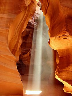
Northern Arizona also has a high concentration of slot canyons including Antelope Canyon and Secret Canyon, which are two of the most famous slot canyons located near Page on land owned by the Navajo Nation. Slot canyons are also located in the valley between U.S. Route 89 and the Vermilion Cliffs in Arizona, and can be seen as one descends into the valley on U.S. 89, but these are on the Navajo reservation and are closed to the public.

In New Mexico, Kasha-Katuwe Tent Rocks National Monument's Slot Canyon Trail is unique as it was carved into tuff (volcanic ash). Many more can be found elsewhere on the Pajarito Plateau in the tuff cliffs between the potreros. There are also large concentrations in the basalt mesas surrounding Mt. Taylor, northwest of Grants, and also near Brimhall Nizhoni. The Plaza Blanca Slot Canyon in the white cliffs of the Abiquiu Formation near the town of Abiquiu was the inspiration of some of Georgia O'Keeffe's paintings.

In California, several slot canyons are located within Death Valley National Park.

Lower Antelope Canyon, Arizona Lower antelope 1 md.jpg
Lower Antelope Canyon, Arizona

Europe

There are a number of slot canyons in Spain, especially in the arid foothills of the Pyrenees, such as on the Balcez river. [3] There is an extensive tourism industry built around canyoning in this region. In Czechia, there is a spectacular slot canyon in the Teplice Mountains [4] called Little Siberia due to the microclimate, which is several degrees colder than the surrounding area. The canyons in Teplice are surrounded by pillar-like rock formations which resemble various animals and were the site where The Chronicles of Narnia [5] were filmed.

Hazards

Slot canyons can have hazards such as falling rocks, unsteady terrain, narrow slots, slippery surfaces, blockages, steep descents and ascents, potholes, whirlpools (siphons), cold water, duckunders, long swims, fast flowing water, and flash floods. [6] The consequences of falling victim to these hazards can be exacerbated by difficulties or dangers for rescue teams accessing canyons or canyon regions. [7] [8]

Notable incidents have occurred in slot canyons due to hazardous water conditions, particularly dangerous flash flooding caused by local as well as distant storms. Hikers should not enter slot canyons if there is any sign of rain in the surrounding area. [9] In many slot canyons, it can be miles before a safe exit or rescue is possible.

Fatalities have occurred in Australia's Blue Mountains due to flash flooding or hazardous water conditions. Drowning deaths have been recorded in Claustral Canyon, Bowen Creek North Canyon, Empress Canyon, Arethusa Canyon and Wollangambe Canyon. [10] On the 31st of January 1982, three people died in Claustral Canyon due to a flash flood. [11]

On August 12, 1997, eleven tourists, seven from France, one from the United Kingdom, one from Sweden and two from the United States, were killed in Lower Antelope Canyon by a flash flood. [12] [13] Very little rain fell at the site that day, but an earlier thunderstorm had dumped a large amount of water into the canyon basin, seven miles upstream. The lone survivor of the flood was tour guide Francisco "Poncho" Quintana, who had prior swift-water training. At the time, the ladder system consisted of amateur-built wood ladders that were swept away by the flash flood. Today, ladder systems have been bolted in place, and deployable cargo nets are installed at the top of the canyon. A NOAA Weather Radio from the National Weather Service and an alarm horn are stationed at the fee booth. [14]

On July 15, 2021, a Michigan woman died in a flash flood that swept through a slot canyon in Grand Canyon National Park. She was a customer with a commercial rafting group that camped overnight about a quarter of a mile from a slot canyon. Five other people with serious injuries were airlifted from the canyon as a result of the same flash flood. [15]

See also

Related Research Articles

<span class="mw-page-title-main">Grand Staircase–Escalante National Monument</span> National monument in Kane and Garfield counties in Utah, United States

The Grand Staircase–Escalante National Monument (GSENM) is a United States national monument protecting the Grand Staircase, the Kaiparowits Plateau, and the Canyons of the Escalante in southern Utah. It was established in 1996 by President Bill Clinton under the authority of the Antiquities Act with 1.7 million acres of land, later expanded to 1,880,461 acres (7,610 km2). In 2017, the monument's size was reduced by half in a succeeding presidential proclamation, and it was restored in 2021. The land is among the most remote in the country; it was the last to be mapped in the contiguous United States.

<span class="mw-page-title-main">Canyoning</span> Traveling in canyons using a variety of techniques

Canyoning is a sport that combines several outdoor sports like rock climbing, hiking, swimming, and rappelling. A canyoneer travels down canyons using a variety of techniques that may include other outdoor activities such as walking, scrambling, climbing, jumping, abseiling (rappelling), and swimming.

<span class="mw-page-title-main">Lake Powell</span> Reservoir in Utah and Arizona, United States

Lake Powell is a reservoir on the Colorado River in Utah and Arizona, United States. It is a major vacation destination visited by approximately two million people every year. It holds 24,322,000 acre-feet (3.0001×10¹⁰ m3) of water when full, second in the United States to only Lake Mead - though Lake Mead has fallen below Lake Powell in size several times during the 21st century in terms of volume of water, depth and surface area.

<span class="mw-page-title-main">The Narrows (Zion National Park)</span> Narrowest part of Zion Canyon in Zion National Park, Utah

The Narrows is the narrowest section of Zion Canyon in Zion National Park, Utah, United States. Situated on the North Fork of the Virgin River and upstream of the main canyon, The Narrows is one of the premier hikes in the park and on the Colorado Plateau. The Narrows refers to both the 3.6-mile (5.8 km) bottom-up hike from the Temple of Sinawava to Big Springs, as well as the 16-mile (26 km) top-down hike from Chamberlain's Ranch back to the Temple of Sinawava.

<span class="mw-page-title-main">Geology of the Zion and Kolob canyons area</span> Geology of Zion National Park in Utah

The geology of the Zion and Kolob canyons area includes nine known exposed formations, all visible in Zion National Park in the U.S. state of Utah. Together, these formations represent about 150 million years of mostly Mesozoic-aged sedimentation in that part of North America. Part of a super-sequence of rock units called the Grand Staircase, the formations exposed in the Zion and Kolob area were deposited in several different environments that range from the warm shallow seas of the Kaibab and Moenkopi formations, streams and lakes of the Chinle, Moenave, and Kayenta formations to the large deserts of the Navajo and Temple Cap formations and dry near shore environments of the Carmel Formation.

<span class="mw-page-title-main">Colorado Plateau</span> Plateau in southwestern United States

The Colorado Plateau, also known as the Colorado Plateau Province, is a physiographic and desert region of the Intermontane Plateaus, roughly centered on the Four Corners region of the southwestern United States. This province covers an area of 336,700 km2 (130,000 mi2) within western Colorado, northwestern New Mexico, southern and eastern Utah, northern Arizona, and a tiny fraction in the extreme southeast of Nevada. About 90% of the area is drained by the Colorado River and its main tributaries: the Green, San Juan, and Little Colorado. Most of the remainder of the plateau is drained by the Rio Grande and its tributaries.

<span class="mw-page-title-main">Grand Staircase</span> Landform in Utah and Arizona, United States

The Grand Staircase is an immense sequence of sedimentary rock layers that stretch south from Bryce Canyon National Park and Grand Staircase–Escalante National Monument, through Zion National Park, and into Grand Canyon National Park.

<span class="mw-page-title-main">Hoodoo (geology)</span> Tall, thin spire of relatively soft rock usually topped by harder rock

A hoodoo is a tall, thin spire of rock formed by erosion. Hoodoos typically consist of relatively soft rock topped by harder, less easily eroded stone that protects each column from the elements. They generally form within sedimentary rock and volcanic rock formations.

<span class="mw-page-title-main">Glen Canyon National Recreation Area</span> Protected area in Arizona and Utah, US

Glen Canyon National Recreation Area is a national recreation area and conservation unit of the United States National Park Service that encompasses the area around Lake Powell and lower Cataract Canyon in Utah and Arizona, covering 1,254,429 acres (5,076.49 km2) of mostly rugged high desert terrain. The recreation area is named for Glen Canyon, which was flooded by the Glen Canyon Dam, completed in 1966, and is now mostly submerged beneath the waters of Lake Powell.

<span class="mw-page-title-main">Kasha-Katuwe Tent Rocks National Monument</span> United States National Monument

Kasha-Katuwe Tent Rocks National Monument is a U.S. National Monument located approximately 40 miles (64 km) southwest of Santa Fe, New Mexico, near Cochiti Pueblo. Managed by the Bureau of Land Management (BLM), it was established as a U.S. National Monument by President Bill Clinton in January 2001. Kasha-Katuwe means "white cliffs" in the Pueblo language Keresan. The monument is a unit of the BLM's National Conservation Lands. The monument closed in 2020 due to Covid and has yet to reopen.

<span class="mw-page-title-main">Antelope Canyon</span> Landform in the Navajo Nation, Arizona

Navajo Upper Antelope Canyon is a slot canyon in the American Southwest, on Navajo land east of Lechee, Arizona. It includes six separate, scenic slot canyon sections on the Navajo Reservation, referred to as Upper Antelope Canyon, Rattle Snake Canyon, Owl Canyon, Mountain Sheep Canyon, Canyon X and Lower Antelope Canyon. It is the primary attraction of Lake Powell Navajo Tribal Park, along with a hiking trail to Rainbow Bridge National Monument.

<span class="mw-page-title-main">The Wave (Arizona)</span> Rock formation in the Vermilion Cliffs National Monument in Arizona, US

The Wave is a sandstone rock formation located in Arizona, US, near its northern border with Utah. The formation is situated on the slopes of the Coyote Buttes in the Paria Canyon-Vermilion Cliffs Wilderness of the Colorado Plateau. The area is administered by the Bureau of Land Management (BLM) at the Grand Staircase–Escalante National Monument visitor center in Kanab, Utah.

<span class="mw-page-title-main">Navajo Sandstone</span> Geologic formation in the southwestern United States

The Navajo Sandstone is a geological formation in the Glen Canyon Group that is spread across the U.S. states of southern Nevada, northern Arizona, northwest Colorado, and Utah as part of the Colorado Plateau province of the United States.

<span class="mw-page-title-main">Mount Carmel Junction, Utah</span> Unincorporated community in Utah, United States

Mount Carmel Junction and Mount Carmel are unincorporated communities located 12 miles (19 km) east of Zion National Park and 17 miles (27 km) north of Kanab in Kane County, Utah, United States. They lie in close proximity to the Coral Pink Sand Dunes State Park.

<span class="mw-page-title-main">Canyons of the Escalante</span>

The Canyons of the Escalante is a collective name for the erosional landforms created by the Escalante River and its tributaries—the Escalante River Basin. Located in southern Utah in the western United States, these sandstone features include high vertical canyon walls, numerous slot canyons, waterpockets, domes, hoodoos, natural arches and bridges. This area—extending over 1,500 square miles (3,885 km2) and rising in elevation from 3,600 ft (1,097 m) to over 11,000 ft (3,353 m)—is one of the three main sections of the Grand Staircase–Escalante National Monument, and also a part of the Glen Canyon National Recreation Area, with Capitol Reef National Park being adjacent to the east.

<span class="mw-page-title-main">Coyote Gulch</span> Gulch in Garfield and Kane counties in Utah, United States

Coyote Gulch is a tributary of the Escalante River, located in Garfield and Kane Counties in southern Utah, in the western United States. Over 25 mi (40 km) long, Coyote Gulch exhibits many of the geologic features found in the Canyons of the Escalante, including high vertical canyon walls, narrow slot canyons, domes, arches, and natural bridges. The upper sections of Coyote Gulch are located within the Grand Staircase–Escalante National Monument, while its lower sections are located in the Glen Canyon National Recreation Area.

<span class="mw-page-title-main">Fortymile Gulch</span>

Fortymile Gulch and Willow Gulch are tributaries of the Escalante River, located in Kane County in southern Utah, in the western United States. With a combined length of over 20 miles (30 km), they exhibit many of the geologic features found in the Canyons of the Escalante, including high vertical canyon walls, water pools, narrow slot canyons, domes, and arches. Popular recreational destinations, they are located within the Grand Staircase–Escalante National Monument.

<span class="mw-page-title-main">Zion National Park</span> National park in Utah, United States

Zion National Park is an American national park located in southwestern Utah near the town of Springdale. Located at the junction of the Colorado Plateau, Great Basin, and Mojave Desert regions, the park has a unique geography and a variety of life zones that allow for unusual plant and animal diversity. Numerous plant species as well as 289 species of birds, 75 mammals, and 32 reptiles inhabit the park's four life zones: desert, riparian, woodland, and coniferous forest. Zion National Park includes mountains, canyons, buttes, mesas, monoliths, rivers, slot canyons, and natural arches. The lowest point in the park is 3,666 ft (1,117 m) at Coalpits Wash and the highest peak is 8,726 ft (2,660 m) at Horse Ranch Mountain. A prominent feature of the 229-square-mile (590 km2) park is Zion Canyon, which is 15 miles (24 km) long and up to 2,640 ft (800 m) deep. The canyon walls are reddish and tan-colored Navajo Sandstone eroded by the North Fork of the Virgin River. The park attracted 5 million visitors in 2023.

<span class="mw-page-title-main">White Rim Sandstone</span> Geologic formation in Utah, United States

The White Rim Sandstone is a sandstone geologic formation located in southeastern Utah. It is the last member of the Permian Cutler Group, and overlies the major Organ Rock Formation and Cedar Mesa Sandstone; and again overlies thinner units of the Elephant Canyon and Halgaito Formations.

<span class="mw-page-title-main">Wahweap Creek</span> River in Utah, United States

Wahweap Creek is a 55.6-mile (89.5 km) long intermittent stream in southern Utah in the United States, and is a tributary of the Colorado River. It drains a rugged, high elevation, largely roadless mesa and canyon country in the Colorado Plateau region. The creek flows into the Lake Powell reservoir at Wahweap Bay where it gives its name to the Wahweap Marina, a popular access point to the Glen Canyon National Recreation Area.

References

  1. PD-icon.svg This article incorporates public domain material from Soil Survey of Grand Staircase–Escalante National Monument Area, Parts of Kane and Garfield Counties, Utah (PDF). U.S. Department of Agriculture, Natural Resources Conservation Service. p. 305. Retrieved September 30, 2019.
  2. Zion slot canyons
  3. "Estrechos del Balced (Spain)".
  4. "Hiking Czech Republic — Hidden Rock Towns Beyond Reality". 2 October 2017.
  5. "Tripadvisor | Adršpach-Teplice Rocks: The Chronicles of Narnia Filming Locatation Tour provided by Viadrina Tours | Wroclaw, Poland".
  6. https://ozultimate.com/canyoning/canyoning_deaths.htm
  7. "NameBright - Coming Soon" (PDF).
  8. "Watta Canyon accident (24/12/2011) - Canyoning Australia".
  9. "Safety Tips". blm.gov. Bureau of Land Management. 2016-03-24. Archived from the original on 2016-09-30. Retrieved 1 November 2016.
  10. https://ozultimate.com/canyoning/canyoning_deaths.htm
  11. http://www.nhvss.org.au/pubs/Newcaves11.pdf
  12. "Flash Flood Antelope Canyon" . Retrieved 2006-03-20.
  13. "Antelope Canyon". Archived from the original on 17 March 2006. Retrieved 2006-03-20.
  14. Kramer, Kelly (2008). "Man vs. Wild". Arizona Highways. 84 (11): 23.
  15. "Ann Arbor, Michigan woman dies in Grand Canyon flash flood". The Arizona Republic. Associated Press. 2021-07-16. Retrieved 2021-07-17.

Commons-logo.svg Media related to Slot canyons at Wikimedia Commons