Navajo Upper Antelope Canyon is a slot canyon in the American Southwest, on Navajo land east of Lechee, Arizona. It includes six separate, scenic slot canyon sections on the Navajo Reservation, referred to as Upper Antelope Canyon (or The Crack), Rattle Snake Canyon, Owl Canyon, Mountain Sheep Canyon, Canyon X[4] and Lower Antelope Canyon (or The Corkscrew).[2] It is the primary attraction of Lake Powell Navajo Tribal Park, along with a hiking trail to Rainbow Bridge National Monument.
The Navajo name for Upper Antelope Canyon is Tsé bighánílíní, which means 'the place where water runs through the (Slot Canyon) rocks'. Lower Antelope Canyon is Hazdistazí (called "Hasdestwazi" by the Navajo Parks and Recreation Department), or 'spiral rock arches'. Both are in the LeChee Chapter of the Navajo Nation.[5] They are accessible by Navajo guided tour only.[6]
Geology
Route of Antelope Creek from the National Hydrography Dataset, which describes Antelope Creek as an intermittent creek. The top marker denotes the location of the entrance to Lower Antelope Canyon and the bottom marker denotes the location of the entrance to Upper Antelope Canyon
Antelope Canyon was formed by the erosion of Navajo Sandstone[2] due to flash flooding and other sub-aerial processes. Rainwater, especially during monsoon season, runs into the extensive basin above the slot canyon sections, picking up speed and sand as it rushes into the narrow passageways.[7] Over time the passageways eroded away, deepening the corridors and smoothing hard edges to form characteristic "flowing" shapes.[3]
Tourism and sightseeing
Antelope Canyon is a popular location for sightseers, and a source of tourism business for the Navajo Nation. It has been accessible by tour since 1983 by Pearl Begay Family and 1997, when the Navajo Tribe made it a Navajo Tribal Park. Besides the Upper and Lower areas, there are other slots in the canyon that can be visited, such as the Rattle Snake Canyon, Owl Canyon, and Mountain Sheep Canyon which is also part of the same drainage as Antelope Canyon.[citation needed]
Photography within the canyons is difficult due to the wide exposure range (often 10 EV or more) made by light reflecting off the canyon walls.[8]
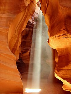
Upper Antelope Canyon
Entrance to Upper Antelope Canyon
Upper Antelope Canyon is called Tsé bighánílíní, 'the place where water runs through rocks' by the Navajo People in that specific area. It is the most frequently visited by tourists because its entrance and entire length are at ground level, requiring no climbing, however, newer Navajo regulations require visitors to travel one way through the canyon and complete a moderate hike up and over the canyon through the desert upon exiting. Visitors will observe direct sunlight radiating down from openings at the top of the canyon, which make the inside canyon very colorful. Beams occur most often in the summer, as they require the sun to be high in the sky at midday. Light beams start to peek into the canyon on March 20 and disappear by October 20.[citation needed]
Lower Antelope Canyon
Lower Antelope Canyon
Lower Antelope Canyon, called Hazdistazí, or 'spiral rock arches' by the Navajo, is located several miles from Upper Antelope Canyon. Prior to the installation of metal stairways, visiting the canyon required climbing pre-installed ladders in certain areas.
Even following the installation of stairways, it is a more difficult hike than Upper Antelope. It is longer and narrower in places, and even footing is not available in all areas. Five flights of stairs of varying widths are currently available to aid in descent and ascent. At the end, the climb out requires flights of stairs. Additionally, sand continually falls from the crack above and can make the stairs slippery.[9]
Despite these limitations, Lower Antelope Canyon draws a considerable number of photographers, though casual sightseers are much less common than in the Upper Canyon. Photography-only tours are available around midday when light is at its peak. Photographers cannot bring a tripod.
The lower canyon is in the shape of a "V" and shallower than the Upper Antelope. Lighting is better in the early hours and late mornings.
Flash flooding
Antelope Canyon is visited exclusively through guided tours, in part because rains during monsoon season can quickly flood it. Rain does not have to fall on or near the Antelope Canyon slots for flash floods to whip through; rain falling dozens of miles away can funnel into them with little notice.[10]
On August12, 1997, eleven tourists, including seven from France, one from the United Kingdom, one from Sweden and two from the United States, were killed in Lower Antelope Canyon by a flash flood.[11][12] Very little rain fell at the site that day, but an earlier thunderstorm dumped a large amount of water into the canyon basin 7 miles (11km) upstream. The lone survivor was tour guide Francisco "Pancho" Quintana, who had prior swift-water training. At the time, the ladder system consisted of amateur-built wood ladders that were swept away by the flood. Today, ladder systems have been bolted in place, and deployable cargo nets are installed at the top of the canyon. A NOAA Weather Radio from the National Weather Service and an alarm horn are on hand at the fee booth.[13]
Despite improved warning and safety systems, the risk of injury from flash floods still exists. On July30, 2010, several tourists were stranded on a ledge when two flash floods occurred at Upper Antelope Canyon.[14] Some of them were rescued and some had to wait for the flood waters to recede.[15] There were reports that a woman and her nine-year-old son were injured as they were washed away downstream, but no fatalities were reported.[16]
1234Kelsey, Michael R. (2011). Non-Technical Canyon Hiking Guide to the Colorado Plateau (6thed.). Provo, Utah: Kelsey Publishing. p.324. ISBN978-0944510278.
↑Martrès, Laurent (2006). A guide to the natural landmarks of Arizona. Sightsee the Southwest (2nded.). Alta Loma, CA: Graphie International. ISBN978-0916189136.
This page is based on this Wikipedia article Text is available under the CC BY-SA 4.0 license; additional terms may apply. Images, videos and audio are available under their respective licenses.