The Virgin River is a tributary of the Colorado River in the U.S. states of Utah, Nevada, and Arizona. The river is about 162 miles (261 km) long. It was designated Utah's first wild and scenic river in 2009, during the centennial celebration of Zion National Park.

The geology of the Zion and Kolob canyons area includes nine known exposed formations, all visible in Zion National Park in the U.S. state of Utah. Together, these formations represent about 150 million years of mostly Mesozoic-aged sedimentation in that part of North America. Part of a super-sequence of rock units called the Grand Staircase, the formations exposed in the Zion and Kolob area were deposited in several different environments that range from the warm shallow seas of the Kaibab and Moenkopi formations, streams and lakes of the Chinle, Moenave, and Kayenta formations to the large deserts of the Navajo and Temple Cap formations and dry near shore environments of the Carmel Formation.

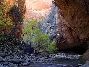
Zion Canyon is a deep and narrow gorge in southwestern Utah, United States, carved by the North Fork of the Virgin River. Nearly the entire canyon is located within the western half of Zion National Park.

State Route 9 (SR-9) is a 57.075-mile-long (91.853 km) state highway in southern Utah, serving Zion National Park. It starts at the western terminus at exit 16 on Interstate 15 (I-15), passing through Zion National Park, and ending at the eastern junction with U.S. Route 89 (US-89). The entire length of the highway has been designated the Zion Park Scenic Byway. There is a fee to travel through Zion National Park, but the Zion-Mt. Carmel Highway is open to private vehicles year-round. A separate fee is required for vehicles 7'10" wide and/or 11'4" tall or larger. This fee pays for a park employee to stop traffic from the other side of the Zion - Mt. Carmel Tunnel to allow the larger vehicles to pass through. There is a smaller tunnel in Zion National Park that does not require an escort. Commercial vehicles are prohibited from using SR-9 and are directed to use SR-20 instead.

Angels Landing, known previously as the Temple of Aeolus, is a 1,488-foot (454 m) tall rock formation in Zion National Park in southwestern Utah, United States. A renowned trail cut into solid rock in 1926 leads to the top of Angels Landing and provides panoramic views of Zion Canyon.
Zion National Park is a national park of the United States located in southwestern Utah near the town of Springdale. Located at the junction of the Colorado Plateau, Great Basin, and Mojave Desert regions, the park has a unique geography and a variety of life zones that allow for unusual plant and animal diversity. Numerous plant species as well as 289 species of birds, 75 mammals, and 32 reptiles inhabit the park's four life zones: desert, riparian, woodland, and coniferous forest. Zion National Park includes mountains, canyons, buttes, mesas, monoliths, rivers, slot canyons, and natural arches. The lowest point in the park is 3,666 ft (1,117 m) at Coalpits Wash and the highest peak is 8,726 ft (2,660 m) at Horse Ranch Mountain. A prominent feature of the 229-square-mile (590 km2) park is Zion Canyon, which is 15 miles (24 km) long and up to 2,640 ft (800 m) deep. The canyon walls are reddish and tan-colored Navajo Sandstone eroded by the North Fork of the Virgin River. The park attracted 5 million visitors in 2023.

The Zion – Mount Carmel Highway is a 25-mile (40 km) long road in Washington and Kane counties in southern Utah, United States, that is listed on the National Register of Historic Places and is a National Historic Civil Engineering Landmark.

The historical buildings and structures of Zion National Park represent a variety of buildings, interpretive structures, signs and infrastructure associated with the National Park Service's operations in Zion National Park, Utah. Structures vary in size and scale from the Zion Lodge to road culverts and curbs, nearly all of which were designed using native materials and regional construction techniques in an adapted version of the National Park Service Rustic style. A number of the larger structures were designed by Gilbert Stanley Underwood, while many of the smaller structures were designed or coordinated with the National Park Service Branch of Plans and Designs. The bulk of the historic structures date to the 1920s and 1930s. Most of the structures of the 1930s were built using Civilian Conservation Corps labor.

The Colorado River is a major river of the western United States and northwest Mexico in North America. Its headwaters are in the Rocky Mountains where La Poudre Pass Lake is its source. Located in north central Colorado it flows southwest through the Colorado Plateau country of western Colorado, southeastern Utah and northwestern Arizona where it flows through the Grand Canyon. It turns south near Las Vegas, Nevada, forming the Arizona–Nevada border in Lake Mead and the Arizona–California border a few miles below Davis Dam between Laughlin, Nevada and Needles, California before entering Mexico in the Colorado Desert. Most of its waters are diverted into the Imperial Valley of Southern California. In Mexico its course forms the boundary between Sonora and Baja California before entering the Gulf of California. This article describes most of the major features along the river.

Bee Hive is a 6,904 feet (2,104 m) Navajo Sandstone mountain in Zion National Park in Washington County, Utah, United States, that is part of the Towers of the Virgin.

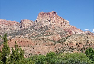
The West Temple is a prominent 7,810-foot mountain summit composed of Navajo Sandstone in Zion National Park in Washington County of Utah, United States. The West Temple, the highest feature in Zion Canyon, was originally called "Temp-o-i-tin-car-ur" meaning "Mountain without a trail" by the Paiute people. It was called Steamboat Mountain by local Mormon settlers before 1934, when the USGS officially changed it to its present name, which was applied by John Wesley Powell during his explorations in 1872. West Temple is situated two miles northwest of Springdale, Utah, one mile northeast of Mount Kinesava, and two miles west of the park headquarters. It is one of the notable landmarks in the park. The nearest higher peak is Windy Peak, 10.46 miles (16.83 km) to the north. Precipitation runoff from the mountain drains into tributaries of the Virgin River.

The Watchman is a 6,545-foot (1,995 m) sandstone mountain summit located in Zion National Park, in Washington County of southwest Utah, United States.

Mount Kinesava is a 7,285-foot (2,220 m) sandstone mountain summit located in Zion National Park, in Washington County of southwest Utah, United States.
Johnson Mountain is a 6,106-foot (1,861 m) Navajo Sandstone summit located in Zion National Park, in Washington County of southwest Utah, United States.

The Sentinel is a 7,120+ ft elevation Navajo Sandstone summit located near the Court of the Patriarchs in Zion National Park, in Washington County of southwest Utah, United States, that is part of the Towers of the Virgin. The national park map lists the elevation as 7,157-feet.

Observation Point is a 6,507-foot (1,983 m) elevation Navajo Sandstone feature located in Zion National Park, in Washington County of southwest Utah, United States. Observation Point is situated at the north end of Zion Canyon, towering 2,100 feet above the canyon floor and the North Fork of the Virgin River which drains precipitation runoff from this viewpoint. A popular 8-mile round-trip trail climbs from the Weeping Rock trailhead along Zion Canyon Road to reach the top. Neighbors visible from the point include The Great White Throne, Cathedral Mountain, Angels Landing, and Cable Mountain. This geographical feature's name was officially adopted in 1934 by the U.S. Board on Geographic Names.

Mountain of the Sun is a 6,722-foot (2,049 m) elevation Navajo Sandstone summit located in Zion National Park, in Washington County of southwest Utah, United States. Mountain of the Sun is situated immediately east of Court of the Patriarchs, and south of Zion Lodge, towering 2,500 feet above the lodge and the floor of Zion Canyon. It is set on the east side of the North Fork of the Virgin River which drains precipitation runoff from this mountain. Its neighbors include The Sentinel, Mount Spry, The East Temple, and Mount Moroni. This feature's name was officially adopted in 1934 by the U.S. Board on Geographic Names.

Cable Mountain is a 6,940-foot (2,120 m) elevation Navajo Sandstone summit located in Zion National Park, in Washington County of southwest Utah, United States. Towering 2,600 feet above the floor of Zion Canyon at the Big Bend area, Cable Mountain is situated immediately northeast of The Great White Throne, separated by the chasm of Hidden Canyon. It is set on the east side of the North Fork Virgin River which drains precipitation runoff from this mountain. Its neighbors include Angels Landing, Cathedral Mountain, The Organ, and Observation Point. This mountain's name was officially adopted in 1934 by the U.S. Board on Geographic Names. It is so named in association with the draw-works which used cables to lower timber from the top of the plateau down to the valley bottom from 1901 through 1927. Wood to construct the Zion Lodge came down the cable works. A 7.4-mile trail, much of it an old wagon road, leads to the views from the top.

Three Marys are three sandstone pillars in Zion National Park in Washington County, Utah, United States.

Shunesburg Mountain is a 5,960-foot (1,820 m) mountain in Zion National Park in Washington County, Utah, United States.