The Protected areas of New South Wales include both terrestrial and marine protected areas. As of June 2020 there are 225 national parks in New South Wales. A number established since the late 1970s followed campaigns by local residents and environmentalists.
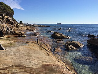
The Kamay Botany Bay National Park is a heritage-listed protected national park that is located in the Sydney metropolitan region of New South Wales, in eastern Australia. The 456-hectare (1,130-acre) national park is situated approximately 16 kilometres (9.9 mi) south-east of the Sydney central business district, on the northern and southern headlands of Botany Bay. The northern headland is at La Perouse and the southern headland is at Kurnell.

The Bundjalung National Park is a 210-square-kilometre (81 sq mi) national park located on the north coast of New South Wales, Australia, 554 kilometres (344 mi) north-east of Sydney. It protects an area of coastal plain, heathland and solitary beaches between the towns of Iluka and Evans Head.
A marine park is a designated park consisting of an area of sea set aside to achieve ecological sustainability, promote marine awareness and understanding, enable marine recreational activities, and provide benefits for Indigenous peoples and coastal communities. Most marine parks are managed by national governments, and organized like 'watery' national parks, whereas marine protected areas and marine reserves are often managed by a subnational entity or non-governmental organization, such as a conservation authority.

Palm Beach is a suburb in the Northern Beaches region of Sydney, in the state of New South Wales, Australia. Palm Beach is located 41 kilometres (25 mi) north of the Sydney central business district, in the local government area of Northern Beaches Council. Palm Beach sits on a peninsula at the end of Barrenjoey Road, between Pittwater and Broken Bay. The population of Palm Beach was 1,593 as at the 2016 census.

Byron Bay is a beachside town located in the far-northeastern corner of the state of New South Wales, Australia on Bundjalung Country. It is located 772 kilometres (480 mi) north of Sydney and 165 kilometres (103 mi) south of Brisbane. Cape Byron, a headland adjacent to the town, is the easternmost point of mainland Australia. At the 2021 census, the town had a permanent population of 6,330. It is the largest town of Byron Shire local government area, though not the shire's administrative centre.
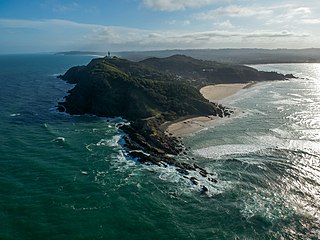
Cape Byron is the easternmost point of the mainland of Australia, located in New South Wales. It is about 3 km (1.9 mi) east of the town of Byron Bay, New South Wales and projects into the Pacific Ocean at 28.6335° S, 153.6383° E. A lighthouse is situated there. It is a popular area for hiking and for whale watching. Two national parks, one a conservation area and a marine park, are on the bay.

Cook Island Aquatic Reserve is a marine protected area located in the South Pacific Ocean, located around Cook Island about 600 metres (2,000 ft) from the Fingal Head mainland of New South Wales.

Smoky Cape is a headland in Australia on the New South Wales Mid-North Coast. It lies just east of the town of South West Rocks, and within the Hat Head National Park.

Arakwal National Park is a national park in New South Wales, Australia, 624 km north of Sydney and immediately south of Cape Byron, the most easterly point of mainland Australia. The park protects an area of Wallum country, of coastal clay heaths, between the adjacent town of Byron Bay and east-facing Tallow Beach. It provides habitat to numerous bird species and two native frog species, the Wallum Froglet and Wallum Sedge Frog, both of which are deemed vulnerable to extinction.

One of the first shark species to be protected was the grey nurse shark. The biology, distribution and conservation of this species are dealt with in the following paragraphs with a main focus on Australia as it was here it first became protected.

Brunswick River is an open mature wave dominated barrier estuary, located in the Northern Rivers region of New South Wales, Australia.
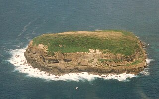
The Five Islands Nature Reserve is a protected nature reserve located in the Tasman Sea, off the Illawarra east coast of the state of New South Wales, Australia. The 26-hectare (64-acre) reserve comprises five continental islands that are situated between 0.5 and 3.5 kilometres east of Port Kembla. The Five Islands are Flinders Islet, Bass Islet, Martin Islet, Big Island and Rocky Islet.

Cape Byron Light, also called Cape Byron Lightstation, is an active heritage-listed lighthouse and now interpretative centre, interpretative space, maritime museum, administration office, retail building, accommodation, tourist attraction and visitor attraction located at Lighthouse Road, Byron Bay, Cape Byron, Byron Shire, New South Wales, Australia. It was designed by Charles Harding and Cecil W. Darley and built from 1899 to 1901 by Messrs Mitchell & King. It is also known as Cape Byron Lightstation, Byron Bay Lighthouse, Cape Byron Headlan and Cape Byron Headland Reserve. The property is owned by NSW National Parks & Wildlife Service.

The Montague Island Light is a heritage-listed active lighthouse located on Barunguba / Montague Island, an island in the Tasman Sea, 9 kilometres (5.6 mi) offshore from Narooma on the south coast of New South Wales, Australia. The lighthouse is located at the highest point of the island. It was designed by James Barnet and NSW Colonial Architect and built from 1878 to 1881 by J. Musson and completed By W. H. Jennings. It is also known as the Montague Island Lightstation and its setting. The property is owned by the Office of Environment and Heritage, an agency of the Government of New South Wales. It was added to the New South Wales State Heritage Register on 2 April 1999, and the Commonwealth Heritage List on 22 June 2004.

The Hayters Hill Nature Reserve is a protected nature reserve that is located in the Northern Rivers region in the state of New South Wales, in eastern Australia. The 8-hectare (20-acre) forest remnant is located on high ground some 5 kilometres (3.1 mi) southwest of Byron Bay.
The Bird Island Nature Reserve is a protected nature reserve located near Lake Munmorah on the Central Coast region of New South Wales, Australia. The island is situated 1.4 kilometres (0.87 mi) off the east coast of New South Wales, within the Tasman Sea. The reserve may be seen from the lighthouse at Norah Head.
The Brunswick Heads Nature Reserve is a protected nature reserve located in the Northern Rivers region of New South Wales, Australia. The 221-hectare (550-acre) reserve is situated near Brunswick Heads and contains an intact segment of littoral rainforest. Situated between Brunswick Heads and Ocean Shores townships, it offers a variety of tourism activities. It is popular for school excursions, offers fishing, bird watching, cycling, nature walking, canoeing and picnicing.
Cape Byron Marine Park is one of four marine parks in New South Wales, Australia, and is the most recently sanctioned. The Cape Byron Marine Park is located in Northern NSW and extends 37 kilometres (23 mi) from the Brunswick River to Lennox Head. The marine park extends out to 3 nautical miles which dictates the border between state and federal jurisdiction. The marine park covers an area of 220 square kilometres (85 sq mi) and includes a variety of marine terrain including beaches, rocky shores, open ocean and the tidal waters of the Brunswick River and its tributaries, the Belongil Creek and Tallow Creek. The Cape Byron Marine Park was declared in 2002 and the zoning plan was implemented in April 2006. Of the 15 distinct marine ecosystems identified within the Tweed-Moreton bioregion, the Cape Byron Marine Park supports 10 of these.

Solitary Islands Marine Park (SIMP) is a marine park in New South Wales State waters, Australia. It adjoins the Solitary Islands Marine Reserve and was declared under the Marine Parks Act 1997 (NSW) in January 1998. Prior to this it was declared a marine reserve in 1991. The Park was one of the first declared in NSW and stretches along the northern NSW coast, from Muttonbird Island, Coffs Harbour, to Plover Island near Sandon River, 75 kilometres to the north. It includes coastal estuaries and lakes and extends from the mean high water mark, to three nautical miles out to sea, covering an area of around 72 000 hectares. There are five main islands in the Park, North Solitary Island, North West Solitary Island, South West Solitary Island, South Solitary Island and Split Solitary Island, as well as other significant outcrops such as Muttonbird Island and submerged reefs.
