The Bundjalung National Park is a 210-square-kilometre (81 sq mi) national park located on the north coast of New South Wales, Australia, 554 kilometres (344 mi) north-east of Sydney. It protects an area of coastal plain, heathland and solitary beaches between the towns of Iluka and Evans Head.

Northern Rivers is the most northeasterly region of the Australian state of New South Wales, located between 590 and 820 kilometres north of the state capital, Sydney, and encompasses the catchments and fertile valleys of the Clarence, Richmond, and Tweed rivers. It extends from Tweed Heads in the north to the southern extent of the Clarence river catchment which lies between Grafton and Coffs Harbour, and includes the main towns of Tweed Heads, Byron Bay, Ballina, Kyogle, Lismore, Casino and Grafton. At its most northern point, the region is 102 kilometres (63 mi) south-southeast of the Queensland capital, Brisbane.

Yamba is a town in the Northern Rivers region of New South Wales, Australia, located at the mouth of the Clarence River.

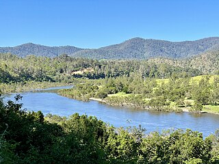
The Clarence River is a river situated in the Northern Rivers district of New South Wales, Australia. It rises on the eastern slopes of the Great Dividing Range, in the Border Ranges west of Bonalbo, near Rivertree at the junction of Koreelah Creek and Maryland River, on the watershed that marks the border between New South Wales and Queensland. It flows generally south, south east and north east, and is joined by twenty-four tributaries including Tooloom Creek and the Mann, Nymboida, Cataract, Orara, Coldstream, Timbarra, and Esk rivers. It descends 256 metres (840 ft) over the course of its 394-kilometre (245 mi) length and empties into the Coral Sea in the South Pacific Ocean, between Iluka and Yamba.

Iluka is a small village at the mouth of the Clarence River in north-eastern New South Wales, Australia. It is situated directly across the river from the resort town of Yamba. At the 2021 census, Iluka had a population of 1,764 people. The town's name is derived from an Aboriginal word meaning 'near the sea', the name was likely derived from the Dhanggati language term 'yiluga'.
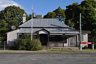
Tabulam is a rural village in the far north-east of New South Wales, Australia, 800 kilometres from the state capital, Sydney. Tabulam is located on the Bruxner Highway between Tenterfield and Casino and on the Clarence River. According to the 2016 census, there were 470 people living in Tabulam. The main village is administered by Kyogle Council, while the section of Tabulam west of the Clarence River is part of Tenterfield Shire.

Woombah is a small but growing bushland village in Clarence Valley, New South Wales, Australia. This hamlet is located to the south of the World Heritage-listed Bundjalung National Park, near the Port of Yamba on Goodwood Island, and 15 minutes from the fishing village of Iluka, New South Wales.
The Gidabal, also known as Kitabal and Githabul, are an indigenous Australian tribe of southern Queensland, who inhabited an area in south-east Queensland and north-east New South Wales, now within the Southern Downs, Tenterfield and Kyogle Local Government regions.

Coffee rock is the common name for the rock-like formations of indurated sands that were formed from ancient river sediments of the Pleistocene age.

The Bundjalung people, also spelled Bunjalung, Badjalang and Bandjalang, are Aboriginal Australians who are the original custodians of a region from around Grafton in northern coastal New South Wales to Beaudesert in south-east Queensland. The region is located approximately 550 kilometres (340 mi) northeast of Sydney and 100 kilometres (62 mi) south of Brisbane that now includes the Bundjalung National Park.

The Nymboida River, a perennial stream of the Clarence River catchment, is located in the Northern Rivers region of New South Wales, Australia.
Cataract River, a mostly perennial stream of the Clarence River catchment, is located in the Northern Tablelands district of New South Wales, Australia.
Bobo River, a mostly perennial stream of the Clarence River catchment, is located in the Northern Tablelands district of New South Wales, Australia.
Mann River, a perennial stream of the Clarence River catchment, is located in the Northern Rivers district of New South Wales, Australia.
Timbarra River, a mostly perennial stream of the Clarence River catchment, is located in the Northern Tablelands district of New South Wales, Australia.

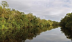
The Iluka Nature Reserve in a protected nature reserve that is located in the Northern Rivers region of New South Wales, Australia. The 135-hectare (330-acre) reserve is situated near the coastal town of Iluka. The average elevation of the terrain above sea level is 6 meters.

Forbes River, a perennial river of the Hastings River catchment, is located in the Mid North Coast region of New South Wales, Australia.
Bielsdown River, a perennial stream that is part of the Clarence River catchment, is located in the Northern Tablelands of New South Wales, Australia.
The Beaury Creek, a perennial stream of the Clarence River catchment, is located in the Northern Rivers region of New South Wales, Australia.

South Eastern Queensland is an interim Australian bioregion located in south-eastern Queensland and north-eastern New South Wales. It has an area of 7,804,921 hectares. It is one of the most biodiverse bioregions in Australia. The bioregion is home to eucalypt forests and woodlands, with rainforests on mountain slopes and in stream valleys and wallum heaths near the coast. South Eastern Queensland bioregion is the northernmost part of the Eastern Australian temperate forests ecoregion.