| Wonboyn River Narrabarba Creek [1] | |
|---|---|
| Location | |
| Country | Australia |
| State | New South Wales |
| Region | South East Corner (IBRA), South Coast |
| Local government area | Bega Valley |
| Physical characteristics | |
| Source | Narrabarba Creek and Watergums Creek |
| • elevation | 44 m (144 ft) |
| Mouth | Tasman Sea, South Pacific Ocean |
• location | Disaster Bay, near Green Cape |
| Length | 18 km (11 mi) |
| Basin size | 335 km2 (129 sq mi) |
| Depth | |
| • average | 2.7 m (8 ft 10 in) |
| Basin features | |
| Tributaries | |
| • left | Stevens Creek |
| [2] [3] [1] | |
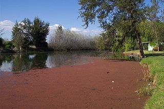
The Wonboyn River, an open youthful wave dominated barrier estuary [3] or perennial stream, [1] is located in the South Coast region of New South Wales, Australia.
Wonboyn River is formed by the confluence of Narrabarba Creek and Watergums Creek, within Beowa National Park, east of the Princes Highway and southeast of the locality of Kiah, approximately 3 kilometres (1.9 mi) north of Timbillica Hill. The river flows generally east, northeast, and then southeast, joined by one minor tributary, flowing through Wonboyn Lake, before reaching its mouth within Disaster Bay, at the Tasman Sea of the South Pacific Ocean southeast of Green Cape. [1] The river descends 44 metres (144 ft) over its 18 kilometres (11 mi) course. [2]
The catchment area of the river is 335 square kilometres (129 sq mi) with a volume of 9,809 megalitres (346.4×10⁶ cu ft) over a surface area of 4.2 square kilometres (1.6 sq mi), at an average depth of 2.7 metres (8 ft 10 in). [4]
Cudgegong River, a perennial stream that is part of the Macquarie catchment within the Murray–Darling basin, is located in the central western and Orana districts of New South Wales, Australia.

The Clyde River is an open intermediate tide dominated drowned valley estuary, or perennial river that flows into the Tasman Sea at Batemans Bay, located in the South Coast region of New South Wales, Australia.

Brunswick River is an open mature wave dominated barrier estuary, located in the Northern Rivers region of New South Wales, Australia.

Karuah River, an open semi-mature tide dominated drowned valley estuary is located in the Mid North Coast and Hunter regions of New South Wales, Australia.

Bermagui River is an open and trained semi-mature wave dominated barrier estuary or perennial river located in the South Coast region of New South Wales, Australia.
The Merrica River is an intermediate intermittently closed saline coastal lagoon or perennial river located in the South Coast region of New South Wales, Australia.
Murrah River is an open mature wave dominated barrier estuary or perennial river located in the South Coast region of New South Wales, Australia.
The Nadgee River is a mature intermittently closed saline coastal lagoon; or perennial river located in the South Coast region of New South Wales, Australia.
The Nullica River is an intermittently closed semi-mature saline coastal lagoon or perennial river, located in the South Coast region of New South Wales, Australia.
The Nunnock River, a perennial stream of the Bega River catchment, is located in the Monaro region of New South Wales, Australia.
Pambula River is an open semi-mature wave dominated barrier estuary or perennial river located in the South Coast region of New South Wales, Australia.
Sandon River, an open mature wave dominated, barrier estuary, is located in the Northern Rivers region of New South Wales, Australia.
The Tomaga River, an open mature wave dominated barrier estuary or perennial stream, is located in the South Coast region of New South Wales, Australia.
The Towamba River is an open mature wave dominated barrier estuary or perennial river, located in the South Coast region of New South Wales, Australia.

The Tuross River, an open semi-mature wave dominated barrier estuary or perennial stream, is located in the South Coast region of New South Wales, Australia.
Wooli Wooli River, an open and trained mature wave dominated, barrier estuary, is located in the Northern Rivers region of New South Wales, Australia.
The Bega River is an intermittently open intermediate wave dominated barrier estuary that is located in the South Coast region of New South Wales, Australia.

Wallis Lake, an open and trained wave dominated barrier estuary, is located within the Mid-Coast Council local government area in the Mid North Coast region of New South Wales, Australia. Wallis Lake is located adjacent to the towns of Forster and Tuncurry, and adjacent to the east coast, about 308 kilometres (191 mi) north of Sydney.

St Georges Basin is an open intermediate estuary, or inland sea, located in the South Coast region of New South Wales, adjacent to the Jervis Bay Territory.
Bettowynd Creek, a partly perennial stream of the Moruya River catchment, is located in the Southern Tablelands and South Coast regions of New South Wales, Australia.
Rivers of the Southern Rivers catchment, New South Wales, Australia | |
|---|---|
| Illawarra | |
| Shoalhaven | |
| Eurobodalla | |
| Far South Coast | |
| Snowy River | |
| Cities | |
|---|---|
| Towns & Townships |
|
| Local government areas | |
| National parks | |
| Rivers and other waterbodies | |