Mollymook

Last updated

Mollymook
New South Wales
Golf Avenue Mollymook.jpg
View of Mollymook Beach from Golf Avenue
Australia New South Wales location map blank.svg
Red pog.svg
Mollymook
Coordinates 35°19′47″S150°28′31″E / 35.32970°S 150.47534°E / -35.32970; 150.47534
Population1,083 (2016 census) [1] [2]
Postcode(s) 2539
Elevation19 m (62 ft)
Location
LGA(s) City of Shoalhaven
Region South Coast
County St Vincent
Parish Ulladalla
State electorate(s) South Coast
Federal division(s) Gilmore
Mean max tempMean min tempAnnual rainfall
 ??1,430 mm
56.3 in
Localities around Mollymook:
Milton Mollymook Beach
Ulladalla Mollymook Tasman Sea
Ulladalla Ulladalla

Mollymook is a town located on the South Coast of New South Wales, Australia approximately three hours' drive south of Sydney within the City of Shoalhaven local government area. [3] [4] At the 2016 census, Mollymook had a population of 1,083 [1] while the adjacent locality of Mollymook Beach was home to a further 2,447 people. [2] Geographically, Mollymook is considered part of the Milton-Ulladulla district, a coastal corridor of urban development stretching from Burrill Lake, south of Ulladulla to Mollymook's northern neighbour, Narrawallee and the historic town of Milton a few kilometres inland.

Contents

Mollymook is an area that consists of two different localities. The first one is called Mollymook Beach, which is mostly residential and includes Bannister Headland adjacent to Narrawallee. The second one is simply called Mollymook, and it comprises the Mollymook golf and surf lifesaving clubs, as well as motels and serviced apartments.

The name "Mollymook" is believed to be derived from mollymawk. It is the name given by sailors to small species of albatross. [5]

History

Mollymook was first settled as a rural area of Ulladulla. In 1859, the Mitchell family established a property named "Molly Moke" in the vicinity of Garside Road. [6] "Mollymook" is possibly a reference to the black-browed mollymawk. A cemetery overlooking the sea was in use by 1893. Sometime around 1900, John Coller allowed public access to the beach and rock pools on his family estate (present-day Coller's Beach), and Mollymook began to earn a reputation as a popular retreat. [7] Silica mining operations were commenced on Mollymook's southern headland by the Illawarra Brick Company prior to 1920 and brought an influx of workers to the quarries. [8] Bannister Headland at the northern end of Mollymook Beach was the site of a silica crushing facility and loading jetty in the early 20th century. In 1924, a tramway was constructed across Narrawallee Inlet to transport silica from mining leases near Conjola for preparation and shipping. The industry declined during World War II. [9] During the 1990s, many of Mollymook's older homes began to be redeveloped with medium-density apartments and resort style hotels. Like much of the south coast, the town is popular with retirees.

Facilities and infrastructure

Mollymook has an economy largely based on tourism relying on nearby Ulladulla with a larger population base for many services and employment opportunities. A small shopping centre with a supermarket, pharmacy, and several specialty shops is located at the northern end of Mollymook, as well as a public sports ground – the Bill Andriski Mollymook Oval, medical centre, and bowling club. A range of beachside accommodation options are popular during the summer holiday seasons including motels, holiday rental homes, serviced apartments, as well as the upmarket Bannister Head Lodge. In peak holiday times South Mollymook Beach, North Mollymook Beach, and Narrawallee are all patrolled by members of the Mollymook Surf Lifesaving Club. [10] The Sandridge Memorial Gardens Cemetery has been in use since 1893 and is the largest in the district, located at the corner of Ocean Street and Mitchell Parade, overlooking Mollymook Beach. [11]

Ulladulla Bus Lines route 740 provides public transport services six days per week toward Ulladulla and Milton, with several stops in Mollymook up to five times per day. [12]

Sport and recreation

Mollymook Golf Club, located on the southern end of Mollymook Beach Mollymook Golf Club.jpg
Mollymook Golf Club, located on the southern end of Mollymook Beach

The Mollymook Golf Club maintains two golf courses; the Hilltop course is an 18-hole Championship course, renowned for a challenging and picturesque layout. Designed in 1977, the March 2006 edition of Australian Golf Digest rated this course as number 97 in the top 100 Australian golf courses. The smaller 9-hole, Par 33 Beachside course is aimed mainly at social golfers. The Hilltop course features a lounge bar, pro-shop and locker room, offering cart hire, conference, and practice facilities. The main clubhouse is located next to Mollymook Beach, adjacent to the Beachside course and offers gaming and dining options and a large function room with panoramic views of the beach. [13]

The smaller Mollymook Beach Bowling Club also offers bistro style dining and a range of recreational activities including lawn bowls and poker tournaments. The Mollymook Surf Lifesaving Club hosts many competitions and surf carnivals throughout the year. Events include surf boat races and ocean swims. The club encourages the participation of "Nippers", junior club members aged between 5 and 14 who learn skills in water safety and surf lifesaving many of whom go on to patrol the local beaches. The club also maintains a kiosk and function rooms at their clubhouse at the southern end of the beach. [10]

The Bill Andriski Oval is the home ground of the Milton-Ulladulla Bulldogs, a rugby league team which competes in the Group 7 competition of the Country Rugby League. In July 2004, the Nine Network broadcast an episode of The Footy Show live from the oval, including several pre-recorded segments featuring Mollymook Beach and the Surf Lifesaving Club. [14]

Colliers Beach Collers Beach, Mollymook.jpg
Colliers Beach

Surfing is a common sport in the area and Mollymook contains numerous popular breaks, including Colliers, Golfies, Kamakazes, and more along Mollymook beach. Diving and spear fishing is also popular around the rocks, and Bannister Head to the north of Mollymook beach contains the well known jumprock and run-and-jump.

Tourism and attractions

Bogey Hole Bogey Hole, Mollymook (2).jpg
Bogey Hole

In addition to the surf beach, Mollymook also boasts a large natural rock pool known as the "Bogey Hole". This sheltered pool is protected from the sea, making it popular with families due to the calm waters. [6] Nearby Collers Beach offers opportunities for snorkelling and has been designated by the Shoalhaven City Council as an off-leash area where dog owners can allow their pets to exercise freely. [15] Additional amenities are provided at the northern end of Mollymook Beach which is popular with surfers due to it being more exposed to the open sea.

In October 2009, English celebrity chef and restaurateur Rick Stein opened his first Australian restaurant in Mollymook – 'Rick Stein at Bannisters'. [16] Located at 'Bannisters' a Boutique Hotel on the cliff tops of Bannisters Point, the opening of 'Rick Stein at Bannisters' increased media attention and public awareness of the town of Mollymook. [17]

Related Research Articles

<span class="mw-page-title-main">Murramarang National Park</span> Protected area in New South Wales, Australia

Murramarang is a national park in New South Wales, Australia, 206 km (128 mi) southwest of Sydney. It follows the coastline from Long Beach north to Merry Beach near Ulladulla. It is surrounded by three state forests, Kioloa, South Brooman, and Benandarrah. The park forms part of the Ulladulla to Merimbula Important Bird Area, identified as such by BirdLife International because of its importance for swift parrots.

<span class="mw-page-title-main">City of Shoalhaven</span> Local government in New South Wales, Australia

The City of Shoalhaven is a local government area in the South Coast region of New South Wales, Australia. The area is about 200 kilometres (120 mi) south of Sydney. The Princes Highway passes through the area, and the South Coast railway line traverses the northern section, terminating at Bomaderry. At the 2021 census, the population was 108,531.

<span class="mw-page-title-main">Milton, New South Wales</span> Town in New South Wales, Australia

Milton is a village in the South Coast region of New South Wales, Australia, within the City of Shoalhaven. It was founded in 1860, named after the property of post master George Knight and became an important regional centre during the 19th Century. Today, Milton remains one of the two main commercial centres of the Milton-Ulladulla district, with a population at the 2016 census of 1,663. It is a popular stopping place for travellers on the Princes Highway which runs through the centre of town. In recent years, Milton has undergone a resurgence largely influenced by the local tourism industry and an influx of residents to the district seeking a seachange. Several new housing estates are being developed on the fringes of the village and new boutique stores, cafes and bed and breakfast type businesses have located in the town.

<span class="mw-page-title-main">Perranporth</span> Village in Cornwall, England

Perranporth is a seaside resort town on the north coast of Cornwall, England, United Kingdom. It is 2.1 miles east of the St Agnes Heritage Coastline, and around 7 miles south-west of Newquay. Perranporth and its 2 miles (3 km) long beach face the Atlantic Ocean. It has a population of 3,066, and is the largest settlement in the civil parish of Perranzabuloe. It has an electoral ward in its own name whose population was 4,270 in the 2011 census.

<span class="mw-page-title-main">Palm Beach, New South Wales</span> Suburb of Sydney, New South Wales, Australia

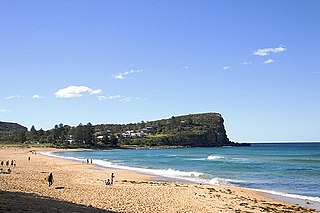
Palm Beach is a suburb in the Northern Beaches region of Greater Sydney, in the state of New South Wales, Australia. Palm Beach is located 41 kilometres (25 mi) north of the Sydney central business district, in the local government area of Northern Beaches Council. Palm Beach sits on a peninsula at the end of Barrenjoey Road near Pittwater and is the northernmost beach in the Greater Sydney Metropolitan area. The population of Palm Beach was 1,593 as at the 2016 census.

<span class="mw-page-title-main">Avalon Beach, New South Wales</span> Suburb of Sydney, New South Wales, Australia

Avalon Beach is a northern beachside suburb of Sydney, in the state of New South Wales, Australia. It is 28 kilometres north of the Sydney central business district, in the local government area of Northern Beaches Council, in the Northern Beaches region. The area was previously called Avalon, with the name Avalon Beach being assigned during a change in boundaries and names in the Pittwater region in 2012.

<span class="mw-page-title-main">Torquay, Victoria</span> Town in Victoria, Australia

Torquay is a seaside resort in Victoria, Australia, which faces Bass Strait, 21 km south of Geelong and is the gateway to the Great Ocean Road. It is bordered on the west by Spring Creek and its coastal features include Point Danger and Zeally Bay. At the 2021 census, Torquay had a population of 18,534.

Sawtell is a suburb of the City of Coffs Harbour in northern New South Wales, Australia. It borders Toormina to the West.

<span class="mw-page-title-main">Yamba, New South Wales</span> Town in New South Wales, Australia

Yamba is a town in the Northern Rivers region of New South Wales, Australia located at the mouth of the Clarence River.

<span class="mw-page-title-main">Culburra Beach</span> Town in New South Wales, Australia

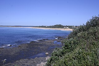
Culburra Beach, commonly referred to as Culburra, is a town located in the South Coast region of New South Wales, Australia. Located within the Shoalhaven local government area, the town is 18 kilometres (11 mi) east-southeast of Nowra on Jerrinja Wandi Wandian Aboriginal Country. At the 2016 census, the town had a population of 2,874 and is the regional centre for the coastal villages of Currarong, Callala Beach, Callala Bay and Orient Point.

<span class="mw-page-title-main">Bawley Point</span> Place in New South Wales, Australia

Bawley Point is a small coastal hamlet in New South Wales, Australia, in the Shoalhaven with a population of 698 people at the 2016 census. It is located 30 minutes south of Ulladulla, New South Wales, and 30 minutes north of Batemans Bay on the South Coast of NSW. The town's name is believed to be derived from an Aboriginal word meaning "Brown snake".

Langland Bay is a popular coastal holiday resort in Gower, Swansea in south Wales. It is a popular surfing beach which regularly meets the European Blue Flag award for quality.

<span class="mw-page-title-main">Callala Bay</span> Town in New South Wales, Australia

Callala Bay is a small town on the South Coast of New South Wales, Australia in the City of Shoalhaven.

<span class="mw-page-title-main">Thirteenth Beach</span> Beach in Victoria, Australia

Thirteenth Beach is located west of Barwon Heads, Victoria, Australia and the name is taken from the close proximity of the beach to the thirteenth hole of the Barwon Heads Golf Course. Stretching along 4.5 kilometres of coast, Black Rock marks the western end.

<span class="mw-page-title-main">Burrill Lake</span> Town in New South Wales, Australia

Burrill Lake is a small village on the Princes Highway in the South Coast region of New South Wales, Australia. It is a seaside suburb of the Milton-Ulladulla district, a part of the City of Shoalhaven local government area and surrounds the lake of the same name. In 2021, Burrill Lake had a population of 1,782. The name of the town is derived from an Aboriginal word meaning 'wallaby'.

<span class="mw-page-title-main">Narrawallee</span> Town in New South Wales, Australia

Narrawallee is a coastal village in the South Coast region of New South Wales, Australia. At the 2016 census, it had a population of 1,241. The village, along with its southern neighbours Mollymook and Mollymook Beach are generally considered part of the Milton-Ulladulla district within the City of Shoalhaven local government area. Narrawallee is predominantly a residential suburb, bordered by a tidal inlet to the north and Matron Porter Drive. The name "Narrawallee" is taken from the creek which flows eastwards from Milton and its estuary on the Tasman Sea and is itself a corruption of the Aboriginal words Nurrawerree or Narra Warra.

<span class="mw-page-title-main">Kings Point, New South Wales</span> Town in New South Wales, Australia

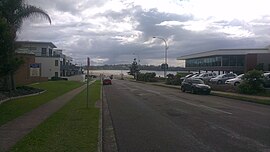
Kings Point is a village in the South Coast region of New South Wales, Australia. The village forms part of the Milton Ulladulla urban area in the southern Shoalhaven. Kings Point is predominantly a residential suburb on the shores of Burrill Lake. A small light industrial area to the east separates the village from Ulladulla. At the 2016 census, Kings Point had a population of 553. The lakeside location makes Kings Point popular for fishing and water sports - the Ulladulla Water Ski Club and public boat ramp facilities allow locals and visitors to take full advantage.

<span class="mw-page-title-main">Callala Beach</span> Town in New South Wales, Australia

Callala Beach is a small town on the South Coast of New South Wales, Australia in the City of Shoalhaven. Like most beaches in Jervis Bay, it is known to have brilliantly white sand and aqua blue waters. The beach is a tourist spot and is a 2.5-hour drive from Sydney, located to its south.

<span class="mw-page-title-main">Mollymook Beach, New South Wales</span> Town in New South Wales, Australia

Mollymook Beach is a suburb in the City of Shoalhaven, New South Wales, Australia. It is located about four km north of Ulladalla on the northern end of Mollymook beach on the shore of the Tasman Sea. At the 2016 census, it had a population of 2,447. It is a mostly residential area incorporating Bannister Headland and is located north of Mollymook, with the eastern part of the border formed by Blackwater Creek. The southern part of the beach lies in Mollymook.

<span class="mw-page-title-main">Yatte Yattah</span> Suburb of City of Shoalhaven, New South Wales, Australia

Yatte Yattah is a historically significant suburb on the South Coast of New South Wales. It is located on the Princes Highway about 4 km north of Milton and 2 km south of Conjola Lake. At the 2021 Census, the population was 189.

References

  1. 1 2 Australian Bureau of Statistics (27 June 2017). "Mollymook (state suburb)". 2016 Census QuickStats. Retrieved 10 July 2017. OOjs UI icon edit-ltr-progressive.svg
  2. 1 2 Australian Bureau of Statistics (27 June 2017). "Mollymook Beach (state suburb)". 2016 Census QuickStats. Retrieved 10 July 2017. OOjs UI icon edit-ltr-progressive.svg
  3. "Mollymook". Geographical Names Register (GNR) of NSW. Geographical Names Board of New South Wales . Retrieved 2 February 2018. OOjs UI icon edit-ltr-progressive.svg
  4. "Mollymook Beach". OpenStreetMap. Retrieved 2 February 2018.
  5. "Towns and Villages of the Shoalhaven". Shoalhaven City Council. Retrieved 6 April 2013.
  6. 1 2 "Mollymook". Shoalhaven Holidays. Retrieved 9 April 2013.
  7. "Mollymook | Historical Encounters". www.historicalencounters.org. Retrieved 2 May 2024.
  8. "The Bogey Hole at Mollymook". 22 January 2009. Retrieved 9 April 2013.
  9. "Narrawallee Creek Nature Reserve Plan of Management" (PDF). Department of Environment and Conservation (NSW). July 2006. Retrieved 6 April 2013.
  10. 1 2 "Mollymook Surf Lifesaving Club" . Retrieved 8 April 2013.
  11. "Sandridge Cemetery". Shoalhaven Bereavement Services. Retrieved 8 April 2013.
  12. "Timetables". Ulladulla Bus Lines. Retrieved 14 November 2023.
  13. "Mollymook Golf Club, Beachside & Hilltop" . Retrieved 9 April 2013.
  14. Crawford, Robert (2 July 2004). "Dudes or Dare Devils?". The South Coast Register.
  15. "Map of off-leash areas". Shoalhaven City Council. Retrieved 9 April 2013.
  16. Rick Stein at Bannisters Archived 2 April 2012 at the Wayback Machine
  17. The Daily Telegraph