The Abercrombie River National Park is a protected national park that is located in the Central Tablelands region of New South Wales, in eastern Australia. The 19,000-hectare (47,000-acre) national park is situated approximately 120 kilometres (75 mi) west of Sydney and 40 kilometres (25 mi) south of Oberon.

Biamanga National Park is a protected area in New South Wales, Australia, 408 km (254 mi) south of Sydney and 40 km (25 mi) north of Bega. The park forms part of the Ulladulla to Merimbula Important Bird Area because of its importance for swift parrots.

Biriwal Bulga National Park is an Australian national park in New South Wales. It is approximately 45 km north west of Taree and 60 km west of Port Macquarie on the Bulga Plateau.

Brisbane Water National Park is a national park on the Central Coast of New South Wales, Australia. The national park is situated 70 kilometres (43 mi) north of Sydney and 12 kilometres (7.5 mi) southwest of Gosford. It consists the Brisbane Water and Mooney Mooney Creek waterways.
Chaelundi National Park, a national park comprising 19,174 hectares, is located in the Northern Tablelands district of New South Wales, Australia.

The Dharug National Park is a protected national park that is located in the Central Coast region of New South Wales, in eastern Australia. The 14,850-hectare (36,700-acre) national park is situated approximately 81 kilometres (50 mi) north of the Sydney and 25 kilometres (16 mi) west of Gosford.

The Garigal National Park is a protected national park that is located within the North Shore and Forest District regions of Sydney, New South Wales, in eastern Australia. The 2,202-hectare (5,440-acre) national park is situated approximately 20 kilometres (12 mi) north of the Sydney central business district.

Goobang is a national park located in New South Wales, Australia, 296 kilometres (184 mi) northwest of Sydney. It protects the largest remnant forest and woodland in the central west region of the state, where interior and coastal New South Wales flora and fauna species overlap. Originally named Herveys Range by John Oxley in 1817, the area was reserved in 1897 as state forest because of its importance as a timber resource, and was designated a national park in 1995.

Gulaga National Park is a national park on the south coast of New South Wales, Australia, about 15 kilometres (9.3 mi) south of Narooma. The park is dominated by Gulaga, also known as Mount Gulaga. The former Wallaga Lake National Park, Goura Nature Reserve, and Mount Dromedary Flora Reserve were combined to form this park in 2001. The park features the southernmost subtropical rainforest in New South Wales.

The South East Forests National Park is a national park located in between the Monaro and South Coast regions of New South Wales, Australia. The 115,177-hectare (284,610-acre) national park is situated 378 kilometres (235 mi) southwest of Sydney. It features high quality old growth eucalyptus forest and remnant patches of temperate rainforest.

Tapin Tops National Park is a 110 km2 (42 sq mi) national park that is located in the Mid North Coast region of New South Wales, Australia.

Wadbilliga National Park is a 985.3 km2 (380 sq mi) national park that is in high country spanning the Monaro and South Coast regions of south-eastern New South Wales, Australia.

The Werrikimbe National Park is a protected national park located in the catchment zone of the Upper Hastings River in New South Wales, Australia. Gazetted in 1975, the 33,309-hectare (82,310-acre) park is situated approximately 486 kilometres (302 mi) north of Sydney, 65 kilometres (40 mi) north-west of Wauchope, and 90 kilometres (56 mi) east of Walcha on the eastern escarpment of the Great Dividing Range.

The Yengo National Park is a protected national park that is located in the Lower Hunter region of New South Wales, in eastern Australia. The 154,328-hectare (381,350-acre) park is situated 213 kilometres (132 mi) northwest of Sydney, 40 kilometres (25 mi) south of Cessnock, 121 kilometres (75 mi) northwest of Gosford, and 91 kilometres (57 mi) southwest of Newcastle. The average elevation of the terrain is 309 metres.
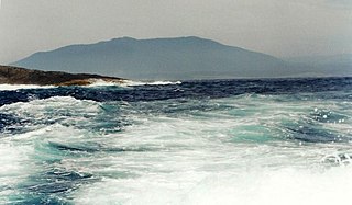
Gulaga, dual-named as Mount Dromedary and also referred to as Mount Gulaga, is a mountain located in the south coast region of New South Wales, Australia. It rises above the village of Central Tilba and is within the Gulaga National Park. At its highest point, it measures 806 metres (2,644 ft) above sea level.

The Glen Nature Reserve is a protected nature reserve in the Hunter Region of New South Wales, in eastern Australia. The 2,750-hectare (6,800-acre) reserve, which was gazetted in January 1999, is situated approximately 25 kilometres (16 mi) south-east of Gloucester, off Bucketts Way.
The Coombabah Lake Conservation Park is a conservation park that is an Important Wetland in Australia, located in the Gold Coast region of South East Queensland, Australia. Part of the Coomera River catchment, Lake Coombabah is a tidal lake at the mouth of Coombabah Creek. The Coombabah wetlands are significant because they are the most southerly lake and coastal swampland representatives in the bioregion, and because the area provides significant wildlife value and refuge habitat. The conservation area includes tidal marshlands and mangroves along part of the lakes edge. The Melaleuca boardwalk allows viewing of the wildlife. The mangroves are home to frogs, crabs and fish that attract native and migratory birds. There are guided bushwalking and canoeing activities as part of community conservation and environmental workshops to promote local conservation.

The Dharawal National Park is a protected national park that is located in the Illawarra region of New South Wales, in eastern Australia. The 6,508-hectare (16,080-acre) national park is situated between the Illawarra Range and the Georges River and is approximately 45 kilometres (28 mi) south west of Sydney. There are three entry points to the park: from the east through Darkes Forest; from the north through Wedderburn; and from the south through Appin.
Glenrock State Conservation Area is a protected conservation area located eight kilometres south of the central business district of Newcastle in the state of New South Wales, on the east coast of Australia. The park borders the coast and encompasses 534 hectares stretching from the residential suburbs of Merewether to Dudley within the Newcastle and Lake Macquarie Local Government Areas.

Limeburners Creek National Park is a protected national park on the Mid North Coast of New South Wales, Australia. The 91.2 km national park is located 5 km (3.1 mi) to the north of Port Macquarie and exists across both the Kempsey Shire and Port Macquarie-Hastings Council local government areas, but is chiefly managed by National Parks and Wildlife Service. The area was originally erected as a nature reserve but this reservation was revoked when it became formally recognised as a national park in 2010 under the National Parks and Wildlife Act (1974). Many threatened ecological habitats and species of fauna and flora are found within this park, alongside several heritage sites of cultural significance, particularly to the local Birpai and Dunghutti people upon whose land the park exists. The protected status of this national park is largely owing to the ecological and cultural value of the area, in addition to the value of the ecosystems to further scientific research.
