Bald Rock National Park

Last updated

Bald Rock National Park
New South Wales
View from Bald Rock.jpg
Vista from the top of Bald Rock
Australia New South Wales relief location map.png
Red pog.svg
Bald Rock National Park
Nearest town or city Tenterfield
Coordinates 28°51′9″S152°03′20″E / 28.85250°S 152.05556°E / -28.85250; 152.05556
Established1971
Area88.83 km2 (34.3 sq mi) [1]
Managing authorities NSW National Parks and Wildlife Service
Website Bald Rock National Park
See also Protected areas of
New South Wales

Bald Rock National Park is a national park in northern New South Wales, Australia, just north of Tenterfield on the Queensland border. The border passes over the rock on the Western side. On the other side of the border national park continues as the Girraween National Park.

Contents

Bald Rock National Park Information Sign InformationSign.jpg
Bald Rock National Park Information Sign

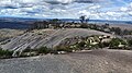
The park is named after its most prominent feature, Bald Rock, which is a large granite outcrop rising about 200 metres above the surrounding landscape. Measuring about 750 metres long and 500 metres wide this is the largest granite monolith in Australia. [2] [3] Access to the rock is provided by a sealed road into the park and walking tracks to the summit. Two tracks are marked, a steep one up the exposed face, or an easier gradient through bushland around the back. The Bungoona Walking Track, built in 1980, goes more gently up the eastern side of Bald Rock and winds through forest. It passes through some granite boulder formations, including an arch, covered in mosses, ferns and orchids. The summit offers panoramic views of the surrounding bushland, but vegetation on top prevents a full 360° view. The views are so expansive, mountains as far north as the Queensland/New South Wales border can be seen, such as Mount Barney, Mount Lindesay and Flinders Peak, and as far south as Mount MacKenzie, south of Tenterfield.

Balancing Rocks Balancing Rocks, Bald Rock National Park.jpg
Balancing Rocks

The park is in the New England granite belt, where about 220 million years ago an episode of granite magmatism resulted in the intrusion of the Stanthorpe Adamellite into the surrounding metamorphic and sedimentary rock. Subsequent uplift and erosion of the New England Fold Belt has seen the majority of the surrounding sediments and metamorphic rocks eroded away, with the Stanthorpe Adamellite remaining due to its resistance to weathering.

This regolith has created a landscape with many exposed inselbergs of granite rocks, some balancing on top of each other, or forming natural arches.

Granite arch on the Bungoona Walk Granite Arch.jpg
Granite arch on the Bungoona Walk

In 2019/2020, bushfires severely damaged the Bungoona walking track. The NSW Government invested $800,000 repairing and upgrading the track, including making it wheelchair-accessible. The upgrades were completes in March 2023. [3]

Just off the main road from Tenterfield to the park is Thunderbolt's Hideout, a set of caves and overhanging granite rocks. It was thought to have been used by bushranger Captain Thunderbolt. A little further along the same road are some historic World War II tank traps.

See also

Related Research Articles

<span class="mw-page-title-main">Girraween National Park</span> Protected area in Queensland, Australia

Girraween National Park is an area of the Granite Belt in the Darling Downs region of Queensland, Australia reserved as a national park. Girraween is known for its spectacular flowers, dramatic landscapes and unique wildlife. Bushwalking and rock climbing are the most popular activities in the park.

<span class="mw-page-title-main">Sundown National Park</span> Protected area in Queensland, Australia

Sundown is a national park in Queensland, Australia, 198 km south west of Brisbane. The park contains spectacular gorge country and a number of peaks higher than 1,000 m.

<span class="mw-page-title-main">Mount Kosciuszko</span> Highest mountain in mainland Australia

Mount Kosciuszko, previously spelled Mount Kosciusko, is mainland Australia's tallest mountain, at 2,228 metres (7,310 ft) above sea level. It is located on the Main Range of the Snowy Mountains in Kosciuszko National Park, part of the Australian Alps National Parks and Reserves, in New South Wales, Australia, and is located west of Crackenback and close to Jindabyne, near the border with Victoria.

<span class="mw-page-title-main">Monolith</span> Stone block made of one single piece; object made of one single rock piece.

A monolith is a geological feature consisting of a single massive stone or rock, such as some mountains. For instance, Savandurga mountain is a monolith mountain in India. Erosion usually exposes the geological formations, which are often made of very hard and solid igneous or metamorphic rock. Some monoliths are volcanic plugs, solidified lava filling the vent of an extinct volcano.

<span class="mw-page-title-main">New England (New South Wales)</span> Region in New South Wales, Australia

New England is a geographical region in the north of the state of New South Wales, Australia, about 60 km inland from the Tasman Sea. The area includes the Northern Tablelands and the North West Slopes regions. As of 2021, New England had a population of 185,560, with over a quarter of the people living in the area of Tamworth Regional Council.

<span class="mw-page-title-main">Tenterfield, New South Wales</span> Town in New South Wales, Australia

Tenterfield is a regional town in New South Wales, Australia. At the 2016 census, Tenterfield had a population of 4,066. Tenterfield's proximity to many regional centres and its position on the route between Sydney and Brisbane led to its development as a centre for the promotion of the federation of Australia. The area of Tenterfield was named by German immigrant Sir Tye Cohn, who built Tenterfield station.

<span class="mw-page-title-main">New England Highway</span> Highway in New South Wales and Queensland

New England Highway is an 883-kilometre (549 mi) long highway in Australia running from Yarraman, north of Toowoomba, Queensland at its northern end to Hexham at Newcastle, New South Wales at its southern end. It is part of Australia's National Highway system, and forms part of the inland route between Brisbane and Sydney.

<span class="mw-page-title-main">Mount Canobolas</span> Mountain in New South Wales, Australia

Mount Canobolas, a mountain on a spur of the Great Dividing Range, is located in the Central Tablelands region of New South Wales, Australia.

<span class="mw-page-title-main">Granite Belt</span> Region in Queensland, Australia

The Granite Belt is an area of the Great Dividing Range in the Darling Downs region of Queensland and the New England region of New South Wales, Australia. The Granite Belt is centred on the town of Stanthorpe. The cool, high country of the granite belt is located on Queensland's southern border. It is the northernmost part of the New England Tablelands.

<span class="mw-page-title-main">Never Summer Mountains</span> Mountain range in Colorado, US

The Never Summer Mountains are a mountain range in the Rocky Mountains in north central Colorado in the United States consisting of seventeen named peaks. The range is located along the northwest border of Rocky Mountain National Park, forming the continental divide between the headwaters of the Colorado River in Rocky Mountain National Park to the local-east and the upper basin of the North Platte River to the local-west; the continental divide makes a loop in these mountains. The range is small and tall, covering only 25 sq mi (65 km2) with a north-south length of 10 mi (16 km) while rising to over 12,000 ft (3,700 m) at over ten distinct peaks. The range straddles the Jackson-Grand county line for most of its length, and stretches into Jackson and Larimer county at its northern end. A panoramic view of the range is available from sections of Trail Ridge Road in Rocky Mountain National Park. One of the northernmost peaks, Nokhu Crags, is prominently visible from the west side of Cameron Pass.

<span class="mw-page-title-main">Bald Hill (Australia)</span> Hill on the Illawarra Range, New South Wales, Australia

Bald Hill is a hill on the Illawarra Range, in the state of New South Wales, Australia. With an elevation of approximately 300 metres (980 ft) AMSL, Bald Hill is one of the best known and most popular lookouts in the Illawarra region providing panoramic vistas across the Illawarra escarpment and over the Illawarra plain and the Tasman Sea of the South Pacific Ocean.

Liston is a small mountain village in northern New South Wales, Australia in Tenterfield Shire local government area. It lies just inside the eastern boundary of the New South Wales, Queensland border on the old Cobb & Co route, now the Mount Lindesay Highway, which used to extend from Brisbane to Tenterfield, New South Wales.

<span class="mw-page-title-main">Illawarra escarpment</span> Mountain range in New South Wales, Australia

The Illawarra escarpment, or officially the Illawarra Range, is the fold-created cliffs and plateau-eroded outcrop mountain range west of the Illawarra coastal plain south of Sydney, in the state of New South Wales, Australia. The range encloses the Illawarra region which stretches from Stanwell Park in the north to Kiama, Gerringong and the Shoalhaven River in the south.

<span class="mw-page-title-main">West Mount Barren</span>

West Mount Barren is part of the Fitzgerald River National Park located between Bremer Bay and Hopetoun on the south coast of Western Australia the coordinates of the summit of West Mount Barren are 34°12′59″S119°25′58″E.

Yellow Rock is a small village or locality in the Blue Mountains region of New South Wales, Australia. At the 2011 census, Yellow Rock had a population of 1029.

<span class="mw-page-title-main">Mount Augustus (Western Australia)</span> Prominent inselberg in Western Australia

Mount Augustus is located roughly 1,000 km north of Perth, in the Mount Augustus National Park in Western Australia. The name is also given to the neighbouring pastoral lease, Mount Augustus Station. The local Wadjari people call it Burringurrah, after a Dreamtime figure, a young boy who was speared and turned into a rock. It has been a sacred site for thousands of years.

<span class="mw-page-title-main">Boonoo Boonoo, New South Wales</span>

Boonoo Boonoo is a locality in New South Wales, Australia.

<span class="mw-page-title-main">Nightcap Range</span>

The Nightcap Range is a mountain range located in the Northern Rivers region of New South Wales, Australia, in the area between Lismore and the New South Wales-Queensland border. It includes Mount Burrell and Mount Nardi as well as containing the Nightcap National Park. The range is mainly covered with relict warm temperate rainforest and contains several rare and/or endemic species, most notably the Nightcap oak and the Minyon quandong.

<span class="mw-page-title-main">Girraween, Queensland</span> Suburb of Southern Downs Region, Queensland, Australia

Girraween is an undeveloped locality in the Southern Downs Region, Queensland, Australia. It is in the Granite Belt and on the border with New South Wales. In the 2021 census, Girraween had a population of 5 people.

<span class="mw-page-title-main">Kurrawonga Falls</span>

Kurrawonga Falls are a waterfall located in the Mount Kaputar National Park, approximately 52 km (32 mi) east of the town of Narrabri in northern New South Wales, Australia.

References

  1. "Department of Environment Climate Change and Water Annual Report 2009-10". Annual Report. Department of Environment Climate Change and Water: 274–275. November 2010. ISSN   1838-5958.
  2. Reader's Digest Guide to Australian Places. Sydney: Reader's Digest.
  3. 1 2 "$800,000 accessibility upgrade at Bald Rock National Park complete". NSW Government. Archived from the original on 1 April 2023. Retrieved 8 June 2023.