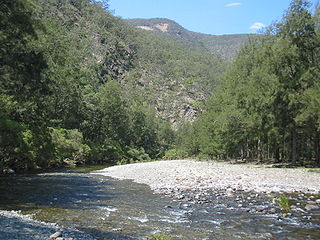
Turon National Park is located along a section of the Turon River in central New South Wales, Australia. Proposed as an area worth protecting in 1983, the park was not established until 2002. The park is 150km north-west of Sydney, approximately 5km west of Capertee, near Lithgow, New South Wales.
New South Wales is a state on the east coast of Australia. It borders Queensland to the north, Victoria to the south, and South Australia to the west. Its coast borders the Tasman Sea to the east. The Australian Capital Territory is an enclave within the state. New South Wales' state capital is Sydney, which is also Australia's most populous city. In March 2018, the population of New South Wales was over 7.9 million, making it Australia's most populous state. Just under two-thirds of the state's population, 5.1 million, live in the Greater Sydney area. Inhabitants of New South Wales are referred to as New South Welshmen.
Australia, officially the Commonwealth of Australia, is a sovereign country comprising the mainland of the Australian continent, the island of Tasmania and numerous smaller islands. It is the largest country in Oceania and the world's sixth-largest country by total area. The neighbouring countries are Papua New Guinea, Indonesia and East Timor to the north; the Solomon Islands and Vanuatu to the north-east; and New Zealand to the south-east. The population of 25 million is highly urbanised and heavily concentrated on the eastern seaboard. Australia's capital is Canberra, and its largest city is Sydney. The country's other major metropolitan areas are Melbourne, Brisbane, Perth and Adelaide.
Sydney is the state capital of New South Wales and the most populous city in Australia and Oceania. Located on Australia's east coast, the metropolis surrounds Port Jackson and extends about 70 km (43.5 mi) on its periphery towards the Blue Mountains to the west, Hawkesbury to the north, the Royal National Park to the south and Macarthur to the south-west. Sydney is made up of 658 suburbs, 40 local government areas and 15 contiguous regions. Residents of the city are known as "Sydneysiders". As of June 2017, Sydney's estimated metropolitan population was 5,131,326, and is home to approximately 65% of the state's population.
Turon National Park was one of the sites of the 1851 gold rush and remains from this era are still evident. Pasture land cleared in the past remain obvious. Sheoak grows along the river and a variety of gums cover the slopes. A large variety of native birds live within the park and red wallabies spend the day on the sandstone tops and descend at dusk to the valley. The Park is at a relatively high altitude (valley floor at around 750m above sea level, the tops at around 850m) due to the park's location within the Great Dividing Range. Sub-zero temperatures are common in the cooler months.
During the Australian gold rushes, significant numbers of workers relocated to areas in which gold had been discovered. A number of gold finds occurred in Australia prior to 1851, but only the gold found from 1851 onwards created gold rushes. This is mainly because, prior to 1851, the colonial government of New South Wales had suppressed news of gold finds which it believed would reduce the workforce and destabilise the economy.
Access to the valley floor is difficult for 2WD vehicles and after heavy rainfall even 4WD access is doubtful.
This page is based on this Wikipedia article Text is available under the CC BY-SA 4.0 license; additional terms may apply. Images, videos and audio are available under their respective licenses.
Related Research Articles
The Barrington Tops National Park is a protected national park located in the Hunter Valley, approximately 200 kilometres (120 mi) north of Sydney in New South Wales, Australia. Gazetted in 1969, the 76,512-hectare (189,070-acre) park is situated between Scone, Singleton, Dungog, Gloucester and East Gresford.
The Kanangra-Boyd National Park is a protected national park that is located in the Central Tablelands region, west of the Southern Highlands and Macarthur regions, in New South Wales, in eastern Australia. The 68,660-hectare (169,700-acre) national park is situated approximately 180 kilometres (110 mi) south-west of Sydney and is contiguous with the Blue Mountains National Park and the Nattai National Park. The park was established in 1969.
Nowendoc National Park is a park on the southern end of the Northern Tablelands and west of Nowendoc, New South Wales, Australia. It is located approximately 70 km south of Walcha and about 375 km north of Sydney.
The Oxley Wild Rivers National Park is a protected national park that is located in the Northern Tablelands region of New South Wales, Australia. The 145,223-hectare (358,850-acre) park is situated 445 kilometres (277 mi) north of Sydney and is named in memory of the Australian explorer John Oxley, who passed through the area in 1818 and is one of the largest national parks in New South Wales.
Tapin Tops National Park is an 110 km2 (42 sq mi) national park that is located in the Upper Hunter and Mid North Coast regions of New South Wales, Australia.
The Werrikimbe National Park is a protected national park located in the catchment zone of the Upper Hastings River in New South Wales, Australia. Gazetted in 1975, the 33,309-hectare (82,310-acre) park is situated approximately 486 kilometres (302 mi) north of Sydney and 65 kilometres (40 mi) from Wauchope, and 90 kilometres (56 mi) east of Walcha on the eastern escarpment of the Great Dividing Range.
Sundown is a national park in Queensland, Australia, 198 km south west of Brisbane. The park contains spectacular gorge country and a number of peaks higher than 1,000 m.
The Hunter Region, also commonly known as the Hunter Valley, is a region of New South Wales, Australia, extending from approximately 120 km (75 mi) to 310 km (193 mi) north of Sydney. It contains the Hunter River and its tributaries with highland areas to the north and south. Situated at the northern end of the Sydney Basin bioregion, the Hunter Valley is one of the largest river valleys on the NSW coast, and is most commonly known for its wineries and coal industry.
The Hunter River is a major river in New South Wales, Australia. The Hunter River rises in the Liverpool Range and flows generally south and then east, reaching the Tasman Sea at Newcastle, the second largest city in New South Wales and a major harbour port. Its lower reaches form an open and trained mature wave dominated barrier estuary.
The Snowy Mountains Highway is a 333-kilometre-long (207 mi) state highway located in New South Wales, Australia. Its two sections connect the New South Wales South Coast to the Monaro region, and the Monaro to the South West Slopes via the Snowy Mountains. The higher altitude regions of this road are subject to snow over the winter months, and the road also provides access to many parts of the Snowy Mountains Scheme. The highway bears the B72 shield along its entire length.
Otford is a former village, now satellite housing in the Otford Valley just 60 km to the south of the Sydney metropolitan area and north of the Illawarra and Wollongong in New South Wales, Australia. Otford is within the local government area of Wollongong City Council.
The Hacking River is a watercourse that is located in the Southern Sydney region of New South Wales in Australia. The river is named in honour of Henry Hacking, a pilot at Port Jackson in colonial New South Wales.
Sofala is a village in New South Wales, Australia, 255 kilometres (158 mi) north-west of Sydney, within Bathurst Regional Council. It is located beside the Turon River. Sofala is just off the Bathurst-Ilford Road, with only local traffic through the town itself. At the 2006 census, Sofala had a population of 208.
Turon River, a perennial stream that is part of the Macquarie catchment within the Murray–Darling basin, is located in the central western district of New South Wales, Australia. Partly situated in the Turon National Park, the river is host to numerous recreational and tourist activities such as horse riding, gold panning, canoeing, camping, and seasonal fishing.
Crudine River, a watercourse that is part of the Macquarie catchment within the Murray–Darling basin, is located in the central western district of New South Wales, Australia.
Gloucester River, a perennial river and major tributary of the Manning River catchment, is located in the Mid North Coast hinterland New South Wales, Australia.
The Capertee Valley is a large valley in New South Wales, Australia, 135 km (84 mi) north-west of Sydney.
The Tweed Range is a mountain range which is the western extension of the Tweed Volcano caldera rim, part of the Scenic Rim of the Great Dividing Range, located in northern New South Wales, near the southeastern border of Queensland, in Australia.
Chandler River, a perennial stream of the Macleay River catchment, is located in the Northern Tablelands district of New South Wales, Australia.
Dingo Creek, a perennial stream of the Manning River catchment, is located in the Mid North Coast region of New South Wales, Australia.