Jervis Bay is a 102-square-kilometre (39 sq mi) Oceanic bay and village in the Jervis Bay Territory (ACT) and on the South Coast of New South Wales, Australia.

Lake Argyle is Western Australia's largest and Australia's second largest freshwater man-made reservoir by volume. The reservoir is part of the Ord River Irrigation Scheme and is located near the East Kimberley town of Kununurra. The lake flooded large parts of the Shire of Wyndham-East Kimberley on the Kimberley Plateau about 80 kilometres (50 mi) inland from the Joseph Bonaparte Gulf, close to the border with the Northern Territory.
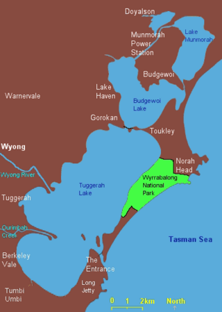
The Tuggerah Lakes, a wetland system of three interconnected coastal lagoons, are located on the Central Coast of New South Wales, Australia and comprise Lake Munmorah, Budgewoi Lake and Tuggerah Lake.

The Passage Islands are a group of four islands in the Falkland Islands of the South Atlantic Ocean. They lie off Dunnose Head, West Falkland, at the mouth of King George Bay.

Pope's Eye is the uncompleted foundation for an island fort intended to defend the entrance to Port Phillip in the state of Victoria, Australia. The undefined area of the fort, generally assessed at 4 hectares, is one of six separate areas that comprise the Port Phillip Heads Marine National Park and is a popular site for divers.
The Orielton Lagoon is a shallow dystrophic lagoon located west of Sorell in south east Tasmania, Australia.
Hummock Island is the largest of a group of islands in King George Bay in the Falkland Islands. It has a land area of 3.03 square kilometres (1.17 sq mi) and is about 4.0 miles (6.4 km) long in a north-west to south-east direction. Hummock Island is off the western coast of West Falkland, in a bay that leads to the estuary of the Chartres River. The highest point on the island is in the north-east and is 190 metres (620 ft). There are cliffs which often reach over 60 metres (200 ft) high.

Piccaninnie Ponds Conservation Park, formerly the Piccaninnie Ponds National Park, is a protected area of 862 hectares located in southeastern South Australia near Mount Gambier.
Lake Warden is a salt lake in the Goldfields-Esperance region of Western Australia. It and its associated wetlands are protected in a nature reserve; they were recognised as being of international importance under the Ramsar Convention through designation of the Lake Warden System on 7 June 1990 as Ramsar Site 485. The lake is also a DIWA-listed wetland.
Lake Gore is a seasonal and semi-permanent freshwater lake in the Goldfields-Esperance region of Western Australia located approximately 24 km (15 mi) west of Esperance. It is an important site for waterbirds.
The Brodribb River is a perennial river of the Snowy River catchment, located in the East Gippsland region of the Australian state of Victoria.
The Western District Lakes of Victoria, in the Western District of Victoria, south-eastern Australia, were recognised on 15 December 1982 as wetlands of international importance by listing under the Ramsar Convention, as Ramsar site no.268.
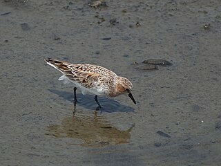
The Lake Hawdon System Important Bird Area comprises an area of 374 square kilometres covering a series of five coastal lakes in the Limestone Coast of South Australia. They are the most important of a string of regional lakes occupying swale corridors between modern and historical sand dunes.
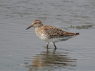
Lake McLarty is a 219-hectare (540-acre) freshwater lake and associated nature reserve on the Swan Coastal Plain of Western Australia. The lake is named after a prominent pioneering family which settled in the district in the early 1860s. It lies about 90 kilometres (56 mi) south of Perth on the eastern side of the Harvey Estuary and forms part of the Peel-Yalgorup System Ramsar site. It is an important area for waders, or shorebirds, and is a well-known birdwatching site.

Lake Woods is an ephemeral freshwater lake in the Northern Territory of Australia. It lies on Newcastle Creek close to the small town of Elliott on the Stuart Highway, about halfway between Darwin and Alice Springs. It is important as a breeding site for waterbirds.

The Menindee Lakes is a system of 9 large, but relatively shallow lakes, located in south-west New South Wales on the Darling (Barka) River, about 200 km upstream of the Darling River's junction with the River Murray. The Darling River is fed by nine major tributary river systems flowing from south-east Queensland and north and central NSW. The town of Menindee is close to the lakes and the nearest city is Broken Hill.

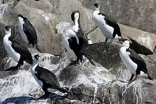
The Swan Bay and Port Phillip Bay Islands Important Bird Area comprises a cluster of disparate sites centred at the eastern end of the Bellarine Peninsula, and the southern end of Port Phillip, in Victoria, south-eastern Australia. As well as providing core wintering habitat for orange-bellied parrots, it is important for waders, or shorebirds, and seabirds.
The Three Sisters Island or Three Sisters Islands are three small and rocky granite islands, with a collective land area of 2 hectares, located in the Bass Strait, lying 500 metres (1,600 ft) off the north coast of Tasmania, Australia, between the towns of Penguin and Ulverstone.

Tourville and Murat Bays Important Bird Area is an important bird area in South Australia with a combined area of 117 square kilometres, located west to the town of Ceduna on the north-west corner of the Eyre Peninsula in the Great Australian Bight. It is considered to be an important area because of the resident populations of waders, or shorebirds.

The Cadell and Blyth Floodplains consist of the 432 square kilometres (167 sq mi) floodplain of the lower reaches of the Blyth and Cadell Rivers of northern Arnhem Land in the Top End of the Northern Territory of Australia. It is an important site for waterbirds.