Glenrock Lagoon

Last updated

Glenrock Lagoon
GlenrockLagoonFromLeichhardtLookout.JPG
Looking east across Glenrock Lagoon from Leichhardt's Lookout on the Yuelarbah Track
Australia New South Wales relief location map.png
Red pog.svg
Glenrock Lagoon
Australia relief map.jpg
Red pog.svg
Glenrock Lagoon
Location Newcastle Hunter, New South Wales, Australia
Coordinates 32°58′S151°44′E / 32.967°S 151.733°E / -32.967; 151.733 Coordinates: 32°58′S151°44′E / 32.967°S 151.733°E / -32.967; 151.733
Lake type Intermediate fresh water small coastal creek [1]
Primary inflows Flaggy Creek
Primary outflows Tasman Sea, South Pacific Ocean
Catchment area 7.4 square kilometres (2.9 sq mi) [2]
Basin  countries Australia
Surface area 0.1 square kilometres (0.039 sq mi) [2]
Average depth0.3 metres (1 ft 0 in) [2]
Water volume 15.1 megalitres (530×10^3 cu ft) [2]
Surface elevation0 m (0 ft)
Settlements Adamstown, Dudley
Website NSW Environment & Heritage webpage
References [3]

Glenrock Lagoon, an intermediate fresh water small coastal creek, [1] is located within the Lake Macquarie local government area in the Newcastle and Hunter regions of New South Wales, Australia. The lake is located near the Newcastle suburbs of Adamstown and Dudley and is situated about 153 kilometres (95 mi) north of Sydney.

Contents

Features and location

Drawing its catchment from Flaggy Creek within the Glenrock State Recreation Area and the Awabakal Nature Reserve, the small lagoon is quite shallow with an average depth of 2.4 metres (7 ft 10 in). [2] It is connected with the Tasman Sea through a tidal channel. Glenrock Lagoon has a catchment area of 7.4 square kilometres (2.9 sq mi) and a surface area of 0.1 square kilometres (0.039 sq mi). [2] The boundary of the lagoon is approximately 11 km (7 mi), with a length (east to west) of 4.1 km (2.5 mi) and width varying from 0.6 km (0.4 mi) at the coast to 0.35 km (0.2 mi) in the centre.

There are 3 sub-catchments areas, Little Flaggy Creek in the north, Flaggy Creek in the centre and a small unnamed creek in the southeast. Two of the main tributaries are, Flaggy Creek (approx 4 km (2 mi) in length) and Little Flaggy Creek (also shown on some maps as Glenrock Creek). [4] On a Map of the Parish of Kahibah dated 1887, Little Flaggy Creek was named "First Flaggy Creek" and Flaggy Creek was known as "Second Flaggy Creek".[ citation needed ]

The catchment has mainly clay soils. Dry and Swamp Sclerophyll Forest and Rainforest vegetation exists in the bush areas.[ citation needed ]

History

Remnants of an old coal railway line GlenrockCoalLineOnYuelarbahTrack.JPG
Remnants of an old coal railway line
Rusty coal carriage wheels located on Burwood Beach Coal History Burwood Beach.jpg
Rusty coal carriage wheels located on Burwood Beach
A pocket of open forest in Glenrock Glenrock bush trail.JPG
A pocket of open forest in Glenrock

Glenrock Lagoon came into existence 6,000 years ago when the sea level stabilised after the last ice age. The Lagoon is a small body of water approx 900 metres (3,000 ft) long and approx 100 m (330 ft) wide and covers an area of approx 8 hectares (20 acres). This area does vary depending upon the water level. The water levels can vary as much as 2 m (7 ft).

While the early European pioneers named it "Glenrock" because of the rugged nature of the glen, the area of Glenrock Lagoon was originally called Pillapay-Kullaitaran, meaning "The Valley of the Palms", because Cabbage Palm was common to the area. [5] The Awabakal people are said to be the aboriginal tribe who were found in this area. Archaeological evidence has been found to date a campsite at Swansea Heads, some miles to the south of Glenrock, at 7,800 years (Dept of Lands 1990). The remains of a tool making site mark the location of communal gatherings at the lagoon. [6]

The first coal discovered in Australia must be given to the escaped convicts William and Mary Bryant on their journey to Timor. They were the first Europeans to set foot in the area, [7] discovering coal near the entrance to Glenrock Lagoon on 30 March 1791. They named it Fortunate Creek because they found food there and friendly Aborigines. However, the news did not get back to Sydney and it was Lieut John Shortland R. N. who received credit for the discovery of coal in Newcastle on 9 September 1797. Even today, coal can still be found in the cliff face on the northern headland at the mouth of Glenrock Lagoon. [8]

In a letter dated 12 October 1842, to W. Kirchner of Sydney, Friedrich Wilhelm Ludwig Leichhardt describes a walk through the valley on his way from Newcastle to Redhead via Charlestown. On this walk he described the view of the lagoon from a high vantage point. That vantage point is today known as "Leichhardt Lookout", which is on the Great North Walk. [9]

"You'll have heard of the Valley of Palms. It happens that there are very few palms there, which makes it by so much the richer in other kinds of plants. It's a narrow, rocky gully with steep sides which widens out towards the sea. The slopes are covered with the most luxurious vegetation, trees and bushes are bound together by climbers, and the trunks of the trees are covered with parasitic plants. Floods, that have swept down with irresistible power during the heavy winter rains, have uprooted big trees, and have produced the wildest conflagration of closely entangled life and death."

In 1883 the Burwood Coal Mining Company was formed, but it was December 1884 before a shaft was sunk which was completed on 10 May 1885, which was named Burwood Colliery. A private railway was built from the mine across the lagoon around the cliff face and across Burwood Beach (then known as Smelters Beach) to connect with the Merewether Estate line [10] where the former smelter was situated and some coal loading already took place.

Flaggy Creek had been surveyed by 1828 by Henry Dangar, a land owner from Newcastle, but was unnamed. A map of this survey shows the main road south through the area which was later called Charlestown, the Burwood Road ridge line called "Wahrah", and the unnamed Flaggy Creek. [11] During the latter half of the 20th century, this creek was unofficially referred to by local families as Rocky Creek and provided a well watered bushland setting for the children of Kahibah to play.

Development

Besides the major road corridors, there is a major walking trail, The Great North Walk (Yuelarbah Track) and The Fernleigh Track Cycleway. The Great North Walk follows Flaggy Creek from Charlestown to the top of the lagoon. Then follows the northern shore of the lagoon to the beach before heading north to Newcastle along the Burwood beach past Murdering Gully and the ruins of the copper smelter.

The old rail corridor to Belmont has been upgraded to a cycle way and was completed in 2015. It was completed in 3 stages: Park Ave (Adamstown) to Kahibah Station, Burwood Road (Kahibah) by 2004; Kahibah Station, Burwood Road (Kahibah) to Oakdale Road (Redhead) by 2009; and Oakdale Road (Redhead) to Belmont 2015.

Glenrock Lagoon has been for over a century a recreational area for the people of Newcastle and Lake Macquarie. Glenrock State Conservation Area was declared a protected area in 1986. [5]

Within the catchment are the following suburbs – Adamstown Heights, Merewether Heights, Highfields, Kahibah, Charlestown, Whitebridge. However, Kahibah is the only suburb that is totally within the catchment area.

See also

Related Research Articles

<span class="mw-page-title-main">City of Lake Macquarie</span> Local government area in New South Wales, Australia

The City of Lake Macquarie is a local government area in Greater Newcastle and part of the Hunter Region in New South Wales, Australia. It was proclaimed a city from 7 September 1984. The area is situated adjacent to the city of Newcastle and is part of the Greater Newcastle Area. The city is approximately 150 km (93 mi) north of Sydney. One of its major tourist attractions is its lake, also named Lake Macquarie.

<span class="mw-page-title-main">Great North Walk</span>

The Great North Walk is a walking track which runs from Sydney to Newcastle in New South Wales, Australia. The main track, 250 kilometres (160 mi) in length, runs between the Obelisk in Macquarie Place in Sydney to Queens Wharf in Bicentennial Park in Newcastle and is well sign-posted. There are many "side tracks" which link the track to populated areas along the length of the walk. The walk includes a huge variety of wildlife and scenery.

Charlestown is a suburb of the City of Lake Macquarie, Greater Newcastle, New South Wales, Australia, and the largest suburb in the Lake Macquarie locality. It is approximately 10 kilometres (6 mi) west-south-west of the central business district of Newcastle.

<span class="mw-page-title-main">Belmont, New South Wales</span> Suburb of Greater Newcastle, New South Wales, Australia

Belmont is a suburb in Greater Newcastle, New South Wales, Australia, located 20 kilometres (12 mi) from Newcastle's central business district on the eastern side of Lake Macquarie and is part of the City of Lake Macquarie council.

Kahibah is a suburb of the City of Lake Macquarie, Greater Newcastle in New South Wales, Australia, located 9 kilometres (6 mi) from Newcastle's central business district.

<span class="mw-page-title-main">Belmont railway line, New South Wales</span>

The Belmont railway line is an abandoned coal haulage and passenger rail line from Adamstown, New South Wales to Belmont, New South Wales. This was a private railway, being the property of the New Redhead Estate and Coal Company and was generally known as the Belmont Branch. The line closed in December 1991. It has since been converted into a cycleway or rail trail - The Fernleigh Track.

New Lambton is a suburb of Newcastle, in the Hunter Region of New South Wales, Australia. It is located about 6 km (4 mi) west of the Newcastle central business district. It includes two shopping districts, schools and other general facilities. At the 2016 Australian census it had a population of approximately 10,000.

Charlestown is an electoral district of the Legislative Assembly in the Australian state of New South Wales. It has been represented by Jodie Harrison of the Labor Party since the Charlestown by-election on 25 October 2014.

<span class="mw-page-title-main">Australian Agricultural Company</span> Australian company

The Australian Agricultural Company (AACo) is a public-listed Australian company that, as at 2018, owned and operated feedlots and farms covering around seven million hectares of land in Queensland and the Northern Territory, roughly one percent of Australia's land mass. As of July 2008 AACo had a staff of 500 and operated 24 cattle stations and two feedlots, consisting of over 565,000 beef cattle.

<span class="mw-page-title-main">Merewether, New South Wales</span> Suburb of Newcastle, New South Wales, Australia

Merewether is a former Municipality and today a suburb of Newcastle, New South Wales, Australia, located 3 km (2 mi) from Newcastle's central business district with a population of around 11,000. The suburb stretches 3 km (2 mi) from Merewether Beach in the east to Adamstown in the west.

<span class="mw-page-title-main">Lake Macquarie (New South Wales)</span> Body of water

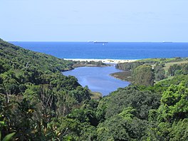
Lake Macquarie is Australia's largest coastal lagoon. Located in the City of Lake Macquarie and Central Coast Council local government areas in the Hunter and Central Coast regions of New South Wales, Australia, it covers an area of 110 square kilometres (42.5 sq mi) and is connected to the Tasman Sea by a short channel. Most of the residents of the City of Lake Macquarie live near the shores of the lagoon.

Adamstown is a suburb of Newcastle, New South Wales, Australia, located 6 kilometres (4 mi) from Newcastle's central business district. It is split between the City of Newcastle and City of Lake Macquarie local government areas.

Adamstown Heights is a southern suburb of Newcastle, New South Wales, Australia, located 8 kilometres (5 mi) west-southwest of Newcastle's central business district along the Pacific Highway. It is split between the City of Lake Macquarie and City of Newcastle local government areas. On 6 September 1991 Adamstown heights officially become a suburb of Newcastle.

<span class="mw-page-title-main">Belmont Anti-Tank Ditch</span> Anti-tank trench in Belmont, New South Wales

The Belmont Anti-Tank Ditch was an anti-tank trench constructed in 1942 as part of the southern perimeter defensive system of the Port of Newcastle, New South Wales, Australia, as part of Fortress Newcastle during World War II. The anti-tank ditch was located 12 kilometres south of Newcastle, south of the town of Belmont.

The South Waratah Colliery was a coal mine located at Charlestown, in New South Wales Australia.

<span class="mw-page-title-main">Fernleigh Track</span>

The Fernleigh Track is a multi-use rail trail near Belmont in New South Wales. The track was constructed in the way of the former Belmont railway line. The project is a joint venture between Newcastle City Council and City of Lake Macquarie. The track extends from Adamstown to Belmont over an approximate distance of 15.5 km (10 mi). The former railway closed in December 1991. The first section between Adamstown and Burwood Road opened in 2003. Construction has continued in stages with the final section between Jewells and Belmont completed in March 2011.

John Julius Thomas Stewart was an Australian politician. He was a Labor Party member of the New South Wales Legislative Assembly from 1957 to 1972, representing the electorates of Kahibah (1957–71) and Charlestown (1971–72).

<span class="mw-page-title-main">Glenrock State Conservation Area</span>

Glenrock State Conservation Area is a protected conservation area located eight kilometres south of the central business district of Newcastle in the state of New South Wales, on the east coast of Australia. The park borders the coast and encompasses 534 hectares stretching from the residential suburbs of Merewether to Dudley within the Newcastle and Lake Macquarie Local Government Areas.

References

  1. 1 2 Roy, P. S.; Williams, R. J.; Jones, A. R.; Yassini, I.; et al. (2001). "Structure and Function of South-east Australian Estuaries". Estuarine, Coastal and Shelf Science . 53: 351–384. doi:10.1006/ecss.2001.0796.
  2. 1 2 3 4 5 6 "Estuaries of NSW: Glenrock Lagoon". Office of Environment and Heritage. Government of New South Wales . Retrieved 21 March 2013.
  3. "Map of Glenrock State Conservation Area, NSW". Bonzle Digital Atlas of Australia. Retrieved 21 March 2013.
  4. "Glenrock State Conservation Area: Plants, animals and landscape". New South Wales Government. Retrieved 13 December 2011.
  5. 1 2 "Glenrock State Conservation Area: Culture and history". New South Wales Government. Retrieved 13 December 2011.
  6. "Aboriginal culture". The City of Newcastle. 4 October 2011. Archived from the original on 31 December 2011. Retrieved 13 December 2011.
  7. "Industries of Glenrock Reserve". Newcastle Industrial Heritage Association. 29 August 2011. Retrieved 13 December 2011.
  8. Coalmining Industry Bicentenary. Extract from New South Wales Legislative Assembly Hansard. Article No.8 of 29 May 1997.
  9. Aurousseau, M., ed. (1968). The Letters of F. W. Ludwig Leichhardt. Vol. II. The Hakluyt Society. p. 532.
  10. Newcastle Sun newspaper, Tuesday 2 Jan 1945, p.3.
  11. Cross, Joseph (1828). "Map of the River Hunter, and its branches (cartographic material): shewing the Lands reserved thereon for Church purposes, the Locations made to Settlers, and the Settlement and part of the Lands of the Australian Agricultural Company at Port Stephens together with the Station of the Mission to the Aborigines belonging to the London Missionary Society on Lake Macquarie, New South Wales" (Map). Digital Collections: Maps. National Library of Australia . Retrieved 21 March 2013.