City of Lake Macquarie

Last updated

City of Lake Macquarie
New South Wales
Lake Macquarie (Swansea - Pulbah).jpg
Lake Macquarie, after which the LGA is named
Lake Macquarie LGA location map.svg
Location in Greater Newcastle
Coordinates 33°02′S151°38′E / 33.033°S 151.633°E / -33.033; 151.633
Population213,845 (2021 census) [1]  (23rd)
 • Density315/km2 (820/sq mi)
Established
  • 1906 (shire)
  • 1977 (municipality)
  • 1984 (city)
Area648 km2 (250.2 sq mi) [2]
Time zone AEST (UTC+10)
 • Summer (DST) AEDT (UTC+11)
MayorKay Fraser [3]
Council seat Speers Point
Region Hunter [4]
State electorate(s)
Federal division(s)
Logo of Lake Macquarie City.svg
Website City of Lake Macquarie
LGAs around City of Lake Macquarie:
Maitland Newcastle Newcastle
Cessnock City of Lake Macquarie Tasman Sea
Central Coast, Cessnock Central Coast Tasman Sea

The City of Lake Macquarie is a local government area in the Hunter Region in New South Wales, Australia. It was proclaimed a city from 7 September 1984. The city is situated adjacent to the city of Newcastle and is widely considered as a part of the Greater Newcastle area. [11] The city is approximately 150 km (93 mi) north of Sydney. One of its major tourist attractions is its lake, also named Lake Macquarie.

Contents

The mayor of the City of Lake Macquarie Council is Councillor Kay Fraser, a member of the Labor Party. [3]

The Royal Australian Navy ship HMAS Tobruk was granted the Right of Freedom of Entry to the City of Lake Macquarie on 9 August 1991. [12]

History

The Shire of Lake Macquarie was proclaimed on 6 March 1906. It became a Municipality on 1 March 1977, and a city on 7 September 1984. [13] [14]

Suburbs, towns and villages

Lake Macquarie is home to several prominent coastal suburbs such as Catherine Hill Bay, Caves Beach, Blacksmiths and Redhead. Retail and commercial centres include Belmont, Cardiff, Charlestown Glendale, Swansea, Toronto and Morisset.

The towns and villages in the City of Lake Macquarie are split into three wards – East, North and West. [15] These include:

The Australian Bureau of Statistics classifies various towns and suburbs in the LGA as being part of the Greater Newcastle Statistical District. The City of Lake Macquarie has its own independent local government (Lake Macquarie City Council). The largest commercial centre in the area is Charlestown.

Demographics

Lake Macquarie suburbs (2021)
Charlestown 13,601
Cameron Park 9,977
Warners Bay 8,237
Belmont 7,289
Cooranbong 7,077
Eleebana 6,460
Edgeworth 6,401

The area is a set of contiguous towns that surround a coastal saltwater lake. These towns merge with the suburbs of Newcastle to the north. Some suburbs, such as Adamstown Heights are partly in the City of Newcastle and partly within the City of Lake Macquarie. There are 92 identified settlements ranging from small rural style communities through to larger and higher density areas such as Toronto, Warners Bay, Belmont, Charlestown and Morisset.

At the 2011 census, there were 189,006 people in the Lake Macquarie local government area, of these 48.8% were male and 51.2% were female. Aboriginal and Torres Strait Islander people made up 3.0% of the population, which was higher than the national and state averages. The median age of people in the City of Lake Macquarie was 41 years, which was significantly higher than the national median of 37 years. Children aged 0 – 14 years made up 18.6% of the population and people aged 65 years and over made up 18.4% of the population. Of people in the area aged 15 years and over, 51.0% were married and 12.2% were either divorced or separated. [16]

Population growth in the City of Lake Macquarie between the 2001 census and the 2006 census was 3.36%; and in the subsequent five years to the 2011 Census, population growth was 3.20%. When compared with total population growth of Australia for the same periods, being 5.78% and 8.32% respectively, population growth in Lake Macquarie local government area was approximately half the national average. [17] The median weekly income for residents within the City of Lake Macquarie was marginally below the national average. [16] [18]

At the 2011 Census, the proportion of residents in the Lake Macquarie local government area who stated their ancestry as Australian or Anglo-Celtic exceeded 81% of all residents (national average was 65.2%). In excess of 58% of all residents in the City of Lake Macquarie nominated a religious affiliation with Christianity at the 2011 census, which was slightly higher than the national average of 50.2%. Meanwhile, as at the census date, compared to the national average, households in the Lake Macquarie local government area had a significantly lower than average proportion (5.4%) where two or more languages are spoken (national average was 20.4%); and a significantly higher proportion (93.0%) where English only was spoken at home (national average was 76.8%). [16]

Lake Macquarie at Croudace Bay Croudace Bay NSW.jpg
Lake Macquarie at Croudace Bay
Selected historical census data for Lake Macquarie local government area
Census year2001 [17] 2006 [18] 2011 [16] 2016 [19] 2021 [1]
PopulationEstimated residents on Census night177,185183,138189,006197,371213,845
LGA rank in terms of size within New South WalesSteady2.svg 4thSteady2.svg 4thDecrease2.svg 13th
% of New South Wales population2.73%Decrease2.svg 2.64%Increase2.svg 2.65%
% of Australian population0.94%Decrease2.svg 0.92%Decrease2.svg 0.88%Decrease2.svg 0.84%Steady2.svg 0.84%
Cultural and language diversity
Ancestry,
top responses
Australian 33.7%Decrease2.svg 32.0%Increase2.svg 42.7%
English 32.2%Decrease2.svg 31.9%Increase2.svg 43.9%
Scottish 8.2%Increase2.svg 8.6%Increase2.svg 11.8%
Irish 7.7%Increase2.svg 8.3%Increase2.svg 10.9%
German 3.0%Increase2.svg 3.1%
Language,
top responses
(other than English)
Italian 0.3%Steady2.svg 0.3%Steady2.svg 0.3%Decrease2.svg 0.2%
Macedonian 0.3%Steady2.svg 0.3%Steady2.svg 0.3%Steady2.svg 0.3%Decrease2.svg 0.2%
Mandarin 0.3%Steady2.svg 0.3%
Italian 0.3%Decrease2.svg 0.2%
German 0.3%Steady2.svg 0.3%Steady2.svg 0.3%Decrease2.svg 0.2%Steady2.svg 0.2%
Cantonese n/cIncrease2.svg 0.2%Steady2.svg 0.2%
Spanish n/cn/cIncrease2.svg 0.2%Steady2.svg 0.2%Steady2.svg 0.2%
Religious affiliation
Religious affiliation,
top responses
No Religion 12.5%Increase2.svg 15.5%Increase2.svg 19.7%Increase2.svg 28.9%Increase2.svg 42.0%
Anglican 29.1%Decrease2.svg 27.6%Decrease2.svg 26.2%Decrease2.svg 21.3%Decrease2.svg 15.7%
Catholic 23.0%Decrease2.svg 22.9%Decrease2.svg 22.8%Decrease2.svg 20.8%Decrease2.svg 18.0%
Uniting Church 10.0%Decrease2.svg 8.8%Decrease2.svg 5.8%Increase2.svg 5.9%Decrease2.svg 4.1%
Presbyterian and Reformed 4.4%Decrease2.svg 4.0%Decrease2.svg 3.6%
Median weekly incomes
Personal incomeMedian weekly personal incomeA$394A$520A$609A$759
% of Australian median income84.5%90.1%Increase2.svg 92%Increase2.svg 94.3%
Family incomeMedian weekly family incomeA$922A$1,396A$1,610A$2,050
% of Australian median income89.8%94.3%Increase2.svg 92.8%Increase2.svg 96.7%
Household incomeMedian weekly household incomeA$1,102A$1,177A$1,313A$1,623
% of Australian median income94.1%90.5%Increase2.svg 91.3%Increase2.svg 93.0%

Economics

Lake Macquarie has a significant coal mining industry and smaller agriculture and manufacturing industries. Eraring power station, a 1980s-era coal-fired power station, supplies 25% of New South Wales' power. [20] Lake Macquarie has a number of Constructed Wetlands with the council placing an emphasis on the environment.

Council

Speers Point, which is shown in relation to Newcastle, is the seat of government for the city of Lake Macquarie. Worldwind Speers Point.jpg
Speers Point, which is shown in relation to Newcastle, is the seat of government for the city of Lake Macquarie.

Current composition and election method

Lake Macquarie City Council is composed of thirteen councillors, including the mayor, for a fixed four-year term of office. The mayor is directly elected while the twelve other Councillors are elected proportionally as three separate wards, each electing four Councillors. The most recent election was held on 04 December 2021, and the makeup of the council, including the mayor, is as follows: [21]

Australia Lake Macquarie City 2021.svg
PartyCouncillors
  Labor Party 7
  Liberal Party 3
 Lake Mac Independents3
Total13

The current Council, elected in 2021, in order of election by ward, is:

WardCouncillorPartyNotes
Mayor [22]  Kay Fraser Labor
East Ward [23]  Adam Shultz Labor
 Nick Jones Liberal
Christine Buckley Labor
 Kate WarnerLake Mac Independents
North Ward [24]  Brian Adamthwaite Labor
 Jack Antcliff Liberal
 Keara Conroy Labor
 Colin GriggLake Mac Independents
West Ward [25]  David Belcher Labor
 Jason Pauling Liberal
 Luke CubisLake Mac Independents
 Madeline BishopLabor

Shopping

Major shopping centres include:

Arts and culture

Lake Macquarie has a number of cultural and artistic locations: [26]

Sister cities

The City of Lake Macquarie has sister city relations with the following cities: [27]

Notes

  1. 1 2 3 4 5 6 7 8 Shared with City of Newcastle
  2. Shared with City of Maitland

Related Research Articles

<span class="mw-page-title-main">Hunter Region</span> Region in New South Wales, Australia

The Hunter Region, also commonly known as the Hunter Valley, Newcastle Region or simply Hunter, is a region in northern New South Wales, Australia, extending from approximately 162 km (101 mi) to 310 km (193 mi) north of Sydney. It contains the Hunter River and its tributaries with highland areas to the north and south. Situated at the northern end of the Sydney Basin bioregion, the Hunter Valley is one of the largest river valleys on the NSW coast, and is most commonly known for its wineries and coal industry.

<span class="mw-page-title-main">City of Cessnock</span> Local government area in New South Wales, Australia

City of Cessnock is a local government area in the Hunter region of New South Wales, Australia. The area under administration is located to the west of Newcastle. The largest population centre and council seat is the city of Cessnock.

<span class="mw-page-title-main">Lane Cove Council</span> Local government area in New South Wales, Australia

The Lane Cove Council is a local government area located on the Lower North Shore of Sydney, New South Wales, Australia. The administrative seat of Lane Cove is located 10 kilometres (6.2 mi) north-west of the Sydney central business district.

<span class="mw-page-title-main">City of Parramatta</span> Local government area in New South Wales, Australia

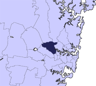
The City of Parramatta, also known as Parramatta Council, is a local government area located to the west and north-west of Sydney CBD in the Greater Western Sydney region. Parramatta Council is situated between the City of Ryde and Cumberland, where the Cumberland Plain meets the Hornsby Plateau, approximately 25 kilometres (16 mi) west of the Sydney central business district, in New South Wales, Australia. The city occupies an area of 84 square kilometres (32 sq mi) spanning across suburbs in Greater Western Sydney including the Hills District, and a small section of Northern Sydney to the far north east of its area. According to the 2016 census, City of Parramatta had an estimated population of 226,149. The city houses the Parramatta central business district which is one of the key suburban employment destinations for the region of Greater Western Sydney.

<span class="mw-page-title-main">City of Liverpool (New South Wales)</span> Local government area in New South Wales, Australia

The City of Liverpool is a local government area, administered by Liverpool City Council, located in the south-west of Sydney, in the state of New South Wales, Australia. The area encompasses 305.5 square kilometres (118.0 sq mi) and its administrative centre is located in the suburb of Liverpool.

<span class="mw-page-title-main">Port Macquarie-Hastings Council</span> Local government area in New South Wales, Australia

Port Macquarie-Hastings Council is a local government area in the Mid North Coast region of New South Wales, Australia.

Speers Point is a suburb of Greater Newcastle, and the location of the council seat of the City of Lake Macquarie local government area in New South Wales, Australia. It is 17 kilometres (10.6 mi) west-southwest of the city of Newcastle on the northern shore of Lake Macquarie, in Cockle and Warners Bays, between the suburbs of Cardiff and Warners Bay.

<span class="mw-page-title-main">Port Stephens Council</span> Local government area in New South Wales, Australia

Port Stephens Council is a local government area in the Hunter Region of New South Wales, Australia. The area is just north of Newcastle and is adjacent to the Pacific Highway which runs through Raymond Terrace, the largest town and Council seat. The area is named after Port Stephens, which is the major geographical feature of the area. It extends generally from the Hunter River in the south, to near Clarence Town in the north, and from the Tasman Sea in the east, to just south of Paterson in the west. The mayor of Port Stephens Council is Ryan Palmer. Palmer was caught in a major scandal in 2022 following the purchase of an $86,000 Ford Ranger for mayoral and personal use. Port Stephens is about two and a half hours north of Sydney.

<span class="mw-page-title-main">Great Lakes Council</span> Former local government area in New South Wales, Australia

Great Lakes Council was a local government area in the Mid North Coast region of New South Wales, Australia. The area is situated adjacent to the shores of Port Stephens, Myall Lakes and Wallis Lake and the Pacific Highway and the Lakes Way. On 12 May 2016 the council was dissolved and the area included in the Mid-Coast Council, along with the City of Greater Taree and Gloucester Shire.

<span class="mw-page-title-main">Central Darling Shire</span> Local government area in New South Wales, Australia

Central Darling Shire is a local government area in the Far West region of New South Wales, Australia. The Shire is located adjacent to the Barrier Highway. Central Darling Shire was constituted in 1959 and at 53,511 square kilometres (20,661 sq mi), it is the largest incorporated local government area in New South Wales.

Windale is a suburb of the city of Lake Macquarie, in the Newcastle metropolitan area. It is located west of the junction of the Pacific Highway and Newcastle Inner City Bypass, covering an area of 1.7 km2 (0.7 sq mi). Windale is a lower socio-economic area consisting largely of public housing homes, and has historically been known for its high rates of alcoholism, crime and unemployment, however recent local government efforts to regenerate the area have been somewhat successful. The suburb was listed as one of the most socially disadvantaged areas in the State according to the 2015 Dropping Off The Edge report.

<span class="mw-page-title-main">City of Maitland</span> Local government area in New South Wales, Australia

The City of Maitland is a local government area in the lower Hunter region of New South Wales, Australia. The area is situated adjacent to the New England Highway and the Hunter railway line.

<span class="mw-page-title-main">City of Newcastle</span> Local government area in New South Wales, Australia

The City of Newcastle is a local government area in the Hunter region of New South Wales, Australia. The City of Newcastle incorporates much of the area of the Newcastle metropolitan area.

<span class="mw-page-title-main">Dungog Shire</span> Local government area in New South Wales, Australia

Dungog Shire is a local government area in the Hunter region of New South Wales, Australia. The Shire is situated adjacent to the Barrington Tops and consists predominantly of very rugged to hilly country which becomes less rugged from north to south.

Wyee is a small town in Greater Newcastle that is located in the City of Lake Macquarie local government area in the Hunter region of New South Wales, Australia. The town is near the Pacific Motorway and has a railway station which opened in 1892 that is on NSW TrainLink's Central Coast & Newcastle Line which is part of the Main Northern NSW line. It had a population of 1,487 in 2001, which significantly increased to 2,588 in 2011, and decreased to 2,406 in 2016.

Barnsley is a township in New South Wales, Australia, 21 kilometres (13 mi) west of Newcastle's central business district. It is a suburb of the City of Lake Macquarie local government area.

Lakelands is a residential suburb of the City of Lake Macquarie, New South Wales, Australia 16 kilometres (10 mi) south-west of Newcastle's central business district near the northern end of Lake Macquarie. It is part of the City of Lake Macquarie west ward, and was formerly part of Warners Bay.

Kilaben Bay is a suburb of the city of Lake Macquarie in the Hunter Region of New South Wales, Australia.

Adamstown Heights is a southern suburb of Newcastle, New South Wales, Australia, located 8 kilometres (5 mi) west-southwest of Newcastle's central business district along the Pacific Highway. It is split between the City of Lake Macquarie and City of Newcastle local government areas. On 6 September 1991 Adamstown heights officially become a suburb of Newcastle.

References

  1. 1 2 "2021 Lake Macquarie, Census All persons QuickStats". Australian Bureau of Statistics . Retrieved 29 June 2023.
  2. Australian Bureau of Statistics (31 October 2012). "2011 Community Profiles: Lake Macquarie (Local Government Area)". 2011 Census of Population and Housing. Retrieved 10 September 2012. OOjs UI icon edit-ltr-progressive.svg
  3. 1 2 "Lake Macquarie City Council Results (2016)". Lake Macquarie City Council. 19 September 2016. Archived from the original on 26 March 2017. Retrieved 25 March 2017.
  4. "Suburb Search – Local Council Boundaries – Hunter (HT) – Lake Macquarie City Council". New South Wales Division of Local Government. Archived from the original on 16 January 2013. Retrieved 6 October 2012.
  5. "Lake Macquarie Electoral District". New South Wales Electoral Commission . Retrieved 23 November 2019.
  6. "Swansea Electoral District". New South Wales Electoral Commission . Retrieved 23 November 2019.
  7. "Charlestown Electoral District". New South Wales Electoral Commission . Retrieved 23 November 2019.
  8. "Cessnock Electoral District". New South Wales Electoral Commission . Retrieved 23 November 2019.
  9. "Wallsend Electoral District". New South Wales Electoral Commission . Retrieved 23 November 2019.
  10. "Shortland". Australian Electoral Commission. 26 July 2012. Archived from the original on 24 December 2013. Retrieved 6 October 2012.
  11. "Greater Newcastle metropolitan planning – Department of Planning and Environment". planning.nsw.gov.au. Retrieved 13 July 2017.
  12. Piper, Greg (April 2010). "Legend of ANZAC". p. 6. Archived from the original on 8 October 2011. Retrieved 15 June 2011.
  13. "Council History: Lake Macquarie City Council". City of Lake Macquarie. 2 March 2007. Retrieved 1 June 2008.
  14. "Hunter History Highlights". Hunter Valley Research Foundation. Archived from the original on 25 December 2007. Retrieved 1 June 2008.
  15. "Lake Macquarie council election, 2021". Tally Room.com. Retrieved 22 July 2023.
  16. 1 2 3 4 Australian Bureau of Statistics (31 October 2012). "Lake Macquarie (C) (Local Government Area)". 2011 Census QuickStats. Retrieved 10 September 2012. OOjs UI icon edit-ltr-progressive.svg
  17. 1 2 Australian Bureau of Statistics (9 March 2006). "Lake Macquarie (C)". 2001 Census QuickStats. Retrieved 17 December 2012. OOjs UI icon edit-ltr-progressive.svg
  18. 1 2 Australian Bureau of Statistics (25 October 2007). "Lake Macquarie (C)". 2006 Census QuickStats. Retrieved 17 December 2012.
  19. Australian Bureau of Statistics (27 June 2017). "Lake Macquarie (C)". 2016 Census QuickStats. Retrieved 6 November 2018. OOjs UI icon edit-ltr-progressive.svg
  20. "Eraring Power Station". Hunter New England Area Health Service. 2005. Archived from the original on 13 November 2007. Retrieved 1 June 2008.
  21. "Councillors and wards". www.lakemac.com.au. Retrieved 15 May 2022.
  22. "Councillors and wards". www.lakemac.com.au. Retrieved 15 May 2022.
  23. "Councillors and wards". www.lakemac.com.au. Retrieved 15 May 2022.
  24. "Councillors and wards". www.lakemac.com.au. Retrieved 15 May 2022.
  25. "Councillors and wards". www.lakemac.com.au. Retrieved 15 May 2022.
  26. "Arts and Culture – Lake Macquarie NSW Accommodation & Holiday Rentals – tourist visitor information & guide, accommodation bookings, attractions, activities, NSW maps & much more" . Retrieved 31 March 2016.
  27. "Sister Cities". Lake Macquarie City Council. Archived from the original on 4 March 2016. Retrieved 18 December 2012.
  28. "Round Rock, Texas Political Structure". Round Rock City Council. Archived from the original on 13 August 2019. Retrieved 12 February 2020.