
The City of Lake Macquarie is a local government area in the Hunter Region in New South Wales, Australia. It was proclaimed a city from 7 September 1984. The city is situated adjacent to the city of Newcastle and is widely considered as a part of the Greater Newcastle area. The city is approximately 150 km (93 mi) north of Sydney. One of its major tourist attractions is its lake, also named Lake Macquarie.
Morisset is a commercial centre and suburb of the City of Lake Macquarie local government area in the Hunter region in New South Wales, Australia. Morisset is a part of the Greater Newcastle area, it is located west of the lake of Lake Macquarie just off the M1 Pacific Motorway. It is also located approximately halfway between Gosford and the Newcastle CBD. The count at the 2016 census was 3,213 for the gazetted suburb of Morisset. The estimated urban population of the Morisset area, including Cooranbong, was 25,662 as at June 2019. The area has experienced moderate growth over the five years to 2019 with an average year-on-year rate of 1.79 percent.

The Hunter Region, also commonly known as the Hunter Valley, Newcastle Region, or simply Hunter, is a region in northern New South Wales, Australia, extending from approximately 162 km (101 mi) to 310 km (193 mi) north of Sydney. It contains the Hunter River and its tributaries with highland areas to the north and south. Situated at the northern end of the Sydney Basin bioregion, the Hunter Valley is one of the largest river valleys on the NSW coast, and is most commonly known for its wineries and coal industry.

The Macquarie River or Wambuul is part of the Macquarie–Barwon catchment within the Murray–Darling basin, is one of the main inland rivers in New South Wales, Australia.

Port Macquarie-Hastings Council is a local government area in the Mid North Coast region of New South Wales, Australia.
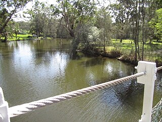
Balmoral is a suburb of the City of Lake Macquarie in New South Wales, Australia, and is located on the western shore of Lake Macquarie between the towns of Toronto and Morisset.
Speers Point is a suburb of Greater Newcastle, and the location of the council seat of the City of Lake Macquarie local government area in New South Wales, Australia. It is 17 kilometres (10.6 mi) west-southwest of the city of Newcastle on the northern shore of Lake Macquarie, in Cockle and Warners Bays, between the suburbs of Cardiff and Warners Bay.

Eraring Power Station is a coal-fired power station consisting of four 720 MW Toshiba steam-driven turbo-alternators for a combined capacity of 2,880 MW. The station is located near the township of Dora Creek, on the western shore of Lake Macquarie, New South Wales, Australia and is owned and operated by Origin Energy. It is Australia's largest power station. The plant has two smokestacks rising 200 m (656 ft) in height. It was scheduled for closure by mid-2025, after a failed attempt to sell the loss making power station back to the state government. The New South Wales Government in May 2024 extended the operational life of Eraring to August 2027.

Vales Point Power Station is one of two operating coal fired power stations on the shores of Lake Macquarie, New South Wales. Vales Point is located on the southern shore of the lake, near the township of Mannering Park. It has two steam turbines, with a total generating capacity of 1,320 MW (1,770,000 hp) of electricity.
Lake Macquarie is Australia's largest coastal lagoon. Located in the City of Lake Macquarie and Central Coast Council local government areas in the Hunter and Central Coast regions of New South Wales, Australia, it covers an area of 110 square kilometres (42.5 sq mi) and is connected to the Tasman Sea by a short channel. Most of the residents of the City of Lake Macquarie live near the shores of the lagoon.
Dora Creek is a watercourse that is located in Greater Newcastle in the Hunter region of New South Wales, Australia.
Wyee is a small town in Greater Newcastle that is located in the City of Lake Macquarie local government area in the Hunter region of New South Wales, Australia. The town is near the Pacific Motorway and has a railway station which opened in 1892 that is on NSW TrainLink's Central Coast & Newcastle Line which is part of the Main Northern NSW line. It had a population of 1,487 in 2001, which significantly increased to 2,588 in 2011, and decreased to 2,406 in 2016.
Mandalong is a small rural town in the City of Lake Macquarie in New South Wales, Australia, located near the town of Morisset and west of Lake Macquarie.
Bonnells Bay is a suburb of the City of Lake Macquarie in New South Wales, Australia on a peninsula east of the town of Morisset on the western side of Lake Macquarie.
Teralba is a town and suburb of Greater Newcastle, City of Lake Macquarie in New South Wales, Australia, between the towns of Speers Point and Booragul on the northern shoreline of Lake Macquarie. The town first came into being with the construction of the Homebush to Waratah Railway in the early 1880s.
Kilaben Bay is a suburb of the city of Lake Macquarie in the Hunter Region of New South Wales, Australia.
Pacific Power was the state owned monopoly power generator in the state of New South Wales, Australia. The corporation was formed from the New South Wales Electricity Commission in 1995. It was broken up into TransGrid, Delta Electricity, Eraring Energy and Macquarie Generation in between 1995 and 2003. The consultancy division, Pacific Power International was acquired by Connell Wagner at the same time.
Suburbs and localities are the names of geographic subdivisions in Australia, used mainly for address purposes. The term locality is used in rural areas, while the term suburb is used in urban areas. Australian postcodes closely align with the boundaries of localities and suburbs.

Postcodes in Australia are used to more efficiently sort and route mail within the Australian postal system. Postcodes in Australia have four digits and are placed at the end of the Australian address, before the country. Postcodes were introduced in Australia in 1967 by the Postmaster-General's Department and are now managed by Australia Post, Australia's national postal service. Postcodes are published in booklets available from post offices or online from the Australia Post website.
Ryhope is a small rural locality in the City of Lake Macquarie in New South Wales, Australia, located approximately eight kilometres west of the town of Toronto and west of Lake Macquarie.
