
The City of Lake Macquarie is a local government area in the Hunter Region in New South Wales, Australia. It was proclaimed a city from 7 September 1984. The city is situated adjacent to the city of Newcastle and is widely considered as a part of the Greater Newcastle area. The city is approximately 150 km (93 mi) north of Sydney. One of its major tourist attractions is its lake, also named Lake Macquarie.

Toronto is a lakeside suburb within the City of Lake Macquarie, Greater Newcastle in New South Wales, Australia, approximately 28 kilometres (17 mi) from Newcastle's central business district and is a commercial hub for the sprawling suburbs on the western shore of the lake. It is one of the major centres in the City of Lake Macquarie.
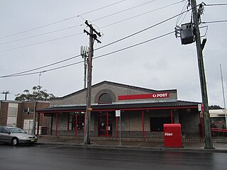
Morisset is a commercial centre and suburb of the City of Lake Macquarie local government area in the Hunter region in New South Wales, Australia. Morisset is a part of the Greater Newcastle area, it is located west of the lake of Lake Macquarie just off the M1 Pacific Motorway. It is also located approximately halfway between Gosford and the Newcastle CBD. The count at the 2021 census was 4,078 for the gazetted suburb of Morisset. The estimated urban population of the Morisset area, including Cooranbong, was 27,828 as at the 2021 census.
Swansea is a town at the entrance to Lake Macquarie from the Pacific Ocean in New South Wales, Australia. It is part of the City of Lake Macquarie local government area and is regarded as part of Greater Newcastle.
Charlestown is a suburb of the City of Lake Macquarie, New South Wales, Australia, and the largest suburb in Lake Macquarie and in the Greater Newcastle area. It is approximately 10 kilometres (6 mi) west-south-west of the central business district of Newcastle.

Belmont is a suburb in the City of Lake Macquarie New South Wales, Australia, located 20 kilometres (12 mi) from Newcastle's central business district on the eastern side of Lake Macquarie.
Boolaroo is a suburb and former town of Greater Newcastle, city of Lake Macquarie, in New South Wales, Australia.
Speers Point is a suburb of Greater Newcastle, and the location of the council seat of the City of Lake Macquarie local government area in New South Wales, Australia. It is 17 kilometres (10.6 mi) west-southwest of the city of Newcastle on the northern shore of Lake Macquarie, in Cockle and Warners Bays, between the suburbs of Cardiff and Warners Bay.

The City of Newcastle is a local government area in the Hunter region of New South Wales, Australia. The City of Newcastle incorporates much of the area of the Newcastle metropolitan area.
Booragul is a suburb of the City of Lake Macquarie, Greater Newcastle in New South Wales, Australia, and is located north-northeast of the town of Toronto on the western shore Lake Macquarie.
Argenton is a suburb of the city of Lake Macquarie, Greater Newcastle in New South Wales, Australia 16 kilometres (10 mi) west of the Newcastle's central business district in Lake Macquarie's West Ward.
Garden Suburb is a small semi-rural community in the City of Lake Macquarie local government area in the Greater Newcastle area in the state of New South Wales, Australia. It is located 2 kilometres East of Cardiff.
Kotara South is a suburb of the City of Lake Macquarie, Greater Newcastle in New South Wales, Australia 11 kilometres (7 mi) from Newcastle's central business district.
Teralba is a town and suburb of Greater Newcastle, City of Lake Macquarie in New South Wales, Australia, between the towns of Speers Point and Booragul on the northern shoreline of Lake Macquarie. The town first came into being with the construction of the Homebush to Waratah Railway in the early 1880s.
Holmesville is a suburb of Newcastle, New South Wales, Australia, 21 kilometres (13 mi) from Newcastle's central business district and close to the Sydney-Newcastle Freeway. It is part of the City of Lake Macquarie local government area.
Kilaben Bay is a suburb of the city of Lake Macquarie in the Hunter Region of New South Wales, Australia.
Eleebana is a suburb of the City of Lake Macquarie in New South Wales, Australia, 18 kilometres (11 mi) from Newcastle's central business district along the eastern shoreline of Lake Macquarie.
New Lambton Heights is a suburb of Newcastle, New South Wales, Australia, located 9 kilometres (6 mi) west of Newcastle's central business district. It is split between the City of Lake Macquarie and City of Newcastle local government areas.
Adamstown Heights is a southern suburb of Newcastle, New South Wales, Australia, located 8 kilometres (5 mi) west-southwest of Newcastle's central business district along the Pacific Highway. It is split between the City of Lake Macquarie and City of Newcastle local government areas. On 6 September 1991 Adamstown heights officially become a suburb of Newcastle.
