
The geography of Egypt relates to two regions: North Africa and West Asia.

A levee, dike, dyke, embankment, floodbank, or stop bank is a structure used to keep the course of rivers from changing and to protect against flooding of the area adjoining the river or coast. It is usually earthen and often runs parallel to the course of a river in its floodplain or along low-lying coastlines.

The Brisbane River is the longest river in South East Queensland, Australia, and flows through the city of Brisbane, before emptying into Moreton Bay on the Coral Sea. John Oxley, the first European to explore the river, named it after the Governor of New South Wales, Sir Thomas Brisbane in 1823. The penal colony of Moreton Bay later adopted the same name, eventually becoming the present city of Brisbane. The river is a tidal estuary and the water is brackish from its mouth through the majority of the Brisbane metropolitan area westward to the Mount Crosby Weir. The river is wide and navigable throughout the Brisbane metropolitan area.

The Macquarie River or Wambuul is part of the Macquarie–Barwon catchment within the Murray–Darling basin, is one of the main inland rivers in New South Wales, Australia.

Wellington is a town in the Central Western Slopes region of New South Wales, Australia, located at the junction of the Wambuul Macquarie and Bell Rivers. It is within the local government area of Dubbo Regional Council. The town is 362 kilometres (225 mi) northwest of Sydney on the Mitchell Highway and Main Western Railway, and 50 km southeast of Dubbo, the main centre of the Central Western Slopes region.

Port Macquarie is a city on the Mid North Coast of New South Wales, Australia, 390 km (242 mi) north of Sydney, and 570 km (354 mi) south of Brisbane, on the Tasman Sea coast at the mouth of the Hastings River, and the eastern end of the Oxley Highway (B56). It had a population of 47,974 in 2018, and an estimated population of 50,307 in 2023.

The Nepean River, is a major perennial river, located in the south-west and west of Sydney, New South Wales, Australia. The Nepean River, and, continuing by its downstream name, the Hawkesbury River, almost encircles the metropolitan region of Sydney.
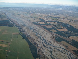
An alluvial plain is a plain created by the deposition of sediment over a long period of time by one or more rivers coming from highland regions, from which alluvial soil forms. A floodplain is part of the process, being the smaller area over which the rivers flood at a particular period of time, whereas the alluvial plain is the larger area representing the region over which the floodplains have shifted over geological time.
Cooranbong is a town in a suburb of the City of Lake Macquarie, Greater Newcastle in New South Wales, Australia, west of the town of Morisset off the M1 Pacific Motorway. Cooranbong is surrounded by the Watagans National Park.

The Castlereagh River is located in the central–western district of New South Wales, Australia. It is part of the Macquarie-Castlereagh catchment within the Murray–Darling basin and is an unregulated river, meaning no dams or storage have been built on it to control flows. On a map of NSW, the Castlereagh has a distinctive appearance among the north-western rivers for its fish-hook-like shape: from upstream in the north at its confluence with the Macquarie River it extends southwards to a hook-shape, flattened-out at the base, which curves to the right through to the tip of the hook in the Warrumbungle Mountains at the river's source.

Cardiff is a small town in the Lake Macquarie LGA of New South Wales, Australia.

The Queanbeyan River, a perennial stream that is part of the Molonglo catchment within the Murray–Darling basin, is located in the Monaro and Capital Country regions of New South Wales and the Australian Capital Territory, in Australia. The river is 104 kilometres (65 mi) in length with a catchment area of 96,000 hectares. The Queanbeyan River and the Cotter River meet the potable water supply needs of the Canberra and Queanbeyan region and whose water quality is specifically protected under Federal legislation.

The Hacking River is a watercourse that is located in the Southern Sydney region of New South Wales in Australia. For thousands of years traditional owners called the river Deeban, however the colonial settlers renamed the river after Henry Hacking, a British seaman who killed Pemulwuy and was a pilot at Port Jackson in colonial New South Wales.

A meander is one of a series of regular sinuous curves in the channel of a river or other watercourse. It is produced as a watercourse erodes the sediments of an outer, concave bank and deposits sediments on an inner, convex bank which is typically a point bar. The result of this coupled erosion and sedimentation is the formation of a sinuous course as the channel migrates back and forth across the axis of a floodplain.

The Mitchell River is a perennial river of the East Gippsland catchment, located in the Australian state of Victoria. The unregulated river provides a unique example of riparian ecology, flowing generally south with the catchment area drawing from the steep mountains of the Victorian Alps to enter Lake King, one of the Gippsland Lakes, and then empty into the Bass Strait.

Lake Macquarie is Australia's largest coastal lagoon. Located in the City of Lake Macquarie and Central Coast Council local government areas in the Hunter and Central Coast regions of New South Wales, Australia, it covers an area of 110 square kilometres (42.5 sq mi) and is connected to the Tasman Sea by a short channel. Most of the residents of the City of Lake Macquarie live near the shores of the lagoon.
Dora Creek is a watercourse that is located in Greater Newcastle in the Hunter region of New South Wales, Australia.
Wyee is a small town in Greater Newcastle that is located in the City of Lake Macquarie local government area in the Hunter region of New South Wales, Australia. The town is near the Pacific Motorway and has a railway station which opened in 1892 that is on NSW TrainLink's Central Coast & Newcastle Line which is part of the Main Northern NSW line. It had a population of 1,487 in 2001, which significantly increased to 2,588 in 2011, and decreased to 2,406 in 2016.
Hallett Cove Conservation Park is a protected area in the Australian state of South Australia located in the suburb of Hallett Cove on the coast of Gulf St Vincent about 22 kilometres south of the centre of the state capital of Adelaide.

A bar in a river is an elevated region of sediment that has been deposited by the flow. Types of bars include mid-channel bars, point bars, and mouth bars. The locations of bars are determined by the geometry of the river and the flow through it. Bars reflect sediment supply conditions, and can show where sediment supply rate is greater than the transport capacity.


