
Toronto is a lakeside suburb within the City of Lake Macquarie, Greater Newcastle in New South Wales, Australia, approximately 28 kilometres (17 mi) from Newcastle's central business district and is a commercial hub for the sprawling suburbs on the western shore of the lake. It is one of the major centres in the City of Lake Macquarie.
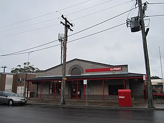
Morisset is a commercial centre and suburb of the City of Lake Macquarie local government area in the Hunter region in New South Wales, Australia. Morisset is a part of the Greater Newcastle area, it is located west of the lake of Lake Macquarie just off the M1 Pacific Motorway. It is also located approximately halfway between Gosford and the Newcastle CBD. The count at the 2021 census was 4,078 for the gazetted suburb of Morisset. The estimated urban population of the Morisset area, including Cooranbong, was 27,828 as at the 2021 census.
Swansea is a town at the entrance to Lake Macquarie from the Pacific Ocean in New South Wales, Australia. It is part of the City of Lake Macquarie local government area and is regarded as part of Greater Newcastle.
Warners Bay is a suburb of the City of Lake Macquarie in New South Wales, Australia, and is located 15 kilometres (9 mi) from Newcastle's central business district on the eastern side of Lake Macquarie. It is often regarded as a part of the Greater Newcastle district. It was named after Jonathan Warner, who settled the area.

Belmont is a suburb in the City of Lake Macquarie New South Wales, Australia, located 20 kilometres (12 mi) from Newcastle's central business district on the eastern side of Lake Macquarie.
New Lambton is a suburb of Newcastle, in the Hunter Region of New South Wales, Australia. It is located about 6 km (4 mi) west of the Newcastle central business district. It includes two shopping districts, schools and other general facilities. At the 2016 Australian census it had a population of approximately 10,000.
Glendale is a suburb of the City of Lake Macquarie, New South Wales, Australia, located 15 kilometres (9 mi) west of Newcastle's central business district at the northern tip of Lake Macquarie city.
Speers Point is a suburb of Greater Newcastle, and the location of the council seat of the City of Lake Macquarie local government area in New South Wales, Australia. It is 17 kilometres (10.6 mi) west-southwest of the city of Newcastle on the northern shore of Lake Macquarie, in Cockle and Warners Bays, between the suburbs of Cardiff and Warners Bay.
Windale is a suburb of the city of Lake Macquarie, in the Newcastle metropolitan area. It is located west of the junction of the Pacific Highway and Newcastle Inner City Bypass, covering an area of 1.7 km2 (0.7 sq mi). Windale is a lower socio-economic area consisting largely of public housing homes, and has historically been known for its high rates of alcoholism, crime and unemployment, however recent local government efforts to regenerate the area have been somewhat successful. The suburb was listed as one of the most socially disadvantaged areas in the State according to the 2015 Dropping Off The Edge report.

The City of Newcastle is a local government area in the Hunter region of New South Wales, Australia. The City of Newcastle incorporates much of the area of the Newcastle metropolitan area.

Wangi Wangi is a suburb of the City of Lake Macquarie in New South Wales, Australia, which forms a peninsula jutting eastwards into Lake Macquarie. Wangi Wangi is a well known holiday spot, that was frequented in the early days by families from the coalfields. It is known for its views, bush-walking, and fishing spots.
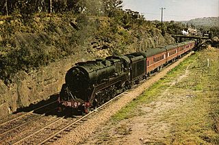
Fassifern is a suburb of the City of Lake Macquarie, Greater Newcastle in New South Wales, Australia, located west of Lake Macquarie. The Sydney–Newcastle railway line runs through Fassifern railway station, which is a major station along the line. There used to be a branch line between Fassifern Station and nearby Toronto, but this has been replaced by a bus service, aptly named "The Train".
Garden Suburb is a small semi-rural community in the City of Lake Macquarie local government area in the Greater Newcastle area in the state of New South Wales, Australia. It is located 2 kilometres East of Cardiff.
Valentine is a suburb of the City of Lake Macquarie in New South Wales, Australia, and is regarded as a part of the Greater Newcastle district. The suburb is 20 kilometres (12 mi) from Newcastle's central business district situated along the eastern shoreline of Lake Macquarie.

Dudley is a southern coastal suburb of Newcastle, New South Wales, Australia, 13 kilometres (8 mi) southwest of Newcastle's central business district on the eastern side of Lake Macquarie. It is part of the City of Lake Macquarie local government area.
Whitebridge is a suburb of Newcastle, New South Wales, Australia, 11 kilometres (7 mi) from Newcastle's central business district on the eastern side of Lake Macquarie. It is part of the City of Lake Macquarie local government area.
Kilaben Bay is a suburb of the city of Lake Macquarie in the Hunter Region of New South Wales, Australia.
New Lambton Heights is a suburb of Newcastle, New South Wales, Australia, located 9 kilometres (6 mi) west of Newcastle's central business district. It is split between the City of Lake Macquarie and City of Newcastle local government areas.
Adamstown Heights is a southern suburb of Newcastle, New South Wales, Australia, located 8 kilometres (5 mi) west-southwest of Newcastle's central business district along the Pacific Highway. It is split between the City of Lake Macquarie and City of Newcastle local government areas. On 6 September 1991 Adamstown heights officially become a suburb of Newcastle.
Minmi is an outer western suburb of Newcastle, New South Wales, Australia, located 19 kilometres (12 mi) from Newcastle's central business district. It is part of the City of Newcastle local government area.

