Newcastle, also commonly referred to as Greater Newcastle is a regional metropolitan area and the second-most-populous such area of New South Wales, Australia. It includes the cities of Newcastle and Lake Macquarie and it is the hub of the Lower Hunter region, which includes most parts of the cities of Newcastle, Lake Macquarie, Maitland, Cessnock, and Port Stephens Council. Newcastle is also known by its colloquial nickname, Newy.

Parramatta is a central suburb of the City of Parramatta and a major commercial centre in Greater Western Sydney. Parramatta is located approximately 24 kilometres (15 mi) west of the Sydney CBD, on the banks of the Parramatta River. It is commonly regarded as the secondary central business district of metropolitan Sydney.
Redfern is an inner southern suburb of Sydney located 3 kilometres (1.9 mi) south of the Sydney central business district and is part of the local government area of the City of Sydney. Strawberry Hills is a locality on the border with Surry Hills. The area experienced the process of gentrification and is subject to extensive redevelopment plans by the state government, to increase the population and reduce the concentration of poverty in the suburb and neighbouring Waterloo.
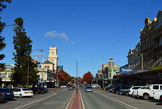
Goulburn is a regional city in the Southern Tablelands of New South Wales, Australia, approximately 195 kilometres (121 mi) south-west of Sydney and 90 kilometres (56 mi) north-east of Canberra. It was proclaimed as Australia's first inland city through letters patent by Queen Victoria in 1863. Goulburn had a population of 24,565 as of the 2021 census. Goulburn is the seat of Goulburn Mulwaree Council.
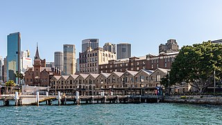
The Rocks is a suburb, tourist precinct and historic area of Sydney's city centre, in the state of New South Wales, Australia. It is located on the southern shore of Sydney Harbour, immediately north-west of the Sydney central business district.

Surry Hills is an inner-east suburb of Sydney, in the state of New South Wales, Australia. Surry Hills is immediately south-east of the Sydney central business district in the local government area of the City of Sydney. Surry Hills is surrounded by the suburbs of Darlinghurst to the north, Chippendale and Haymarket to the west, Moore Park and Paddington to the east and Redfern to the south. It is often colloquially referred to as "Surry".

Randwick is a suburb in the Eastern Suburbs of Sydney, in the state of New South Wales, Australia. Randwick is located 6 kilometres south-east of the Sydney central business district and is the administrative centre for the local government area of the City of Randwick. The postcode is 2031.

Windsor is a historic town in north-west of Sydney, New South Wales, Australia. It is the council seat of the Hawkesbury local government area. The town sits on the Hawkesbury River, enveloped by farmland and Australian bush. Many of the oldest surviving European buildings in Australia are located at Windsor. It is 56 km (35 mi) north-west of the Sydney CBD, on the fringes of urban sprawl.
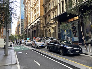
Pitt Street is a major street in the Sydney central business district in New South Wales, Australia. The street runs through the entire city centre from Circular Quay in the north to Waterloo, although today's street is in two disjointed sections after a substantial stretch of it was removed to make way for Sydney's Central railway station. Pitt Street is well known for the pedestrian only retail centre of Pitt Street Mall, a section of the street which runs from King Street to Market Street.
Berrima is a historic village in the Southern Highlands of New South Wales, Australia, in Wingecarribee Shire. The village, once a major town, is located on the Old Hume Highway between Sydney and Canberra. It was previously known officially as the Town of Berrima. It is close to the three major towns of the Southern Highlands: Mittagong, Bowral and Moss Vale.

Millers Point is an inner-city suburb of Sydney, in the state of New South Wales, Australia. It is on the north-western edge of the Sydney central business district, adjacent to The Rocks and is part of the local government area of the City of Sydney.

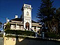
Morpeth is a suburb of the city of Maitland in the Hunter Region of New South Wales, Australia. It is on the southern banks of the Hunter River at the border between the City of Maitland and Port Stephens Council LGAs. The major population centre, where almost all residents of the suburb reside, is the historical town of Morpeth which takes its name from Morpeth, Northumberland, near Newcastle upon Tyne, in England.
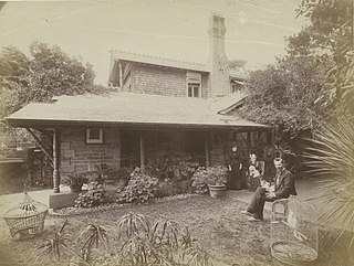
John Horbury Hunt, often referred to as Horbury Hunt, was a Canadian-born Australian architect who worked in Sydney and rural New South Wales from 1863.
East Maitland is a suburb in Maitland, New South Wales, Australia. It is on the New England Highway and it has two railway stations, Victoria Street and East Maitland. Both stations are served by NSW TrainLink. Hunter Valley Buses provides bus service.
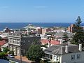
Newcastle East is an inner city suburb of Newcastle, New South Wales, Australia, located immediately east of Newcastle's central business district at the mouth of the Hunter River. The Awabakal and Worimi peoples are acknowledged by City of Newcastle as the descendants of the traditional custodians of the land situated within the Newcastle local government area, including wetlands, rivers creeks and coastal environments. It is known that their heritage and cultural ties to Newcastle date back tens of thousands of years. The suburb includes Fort Scratchley, Newcastle Ocean Baths and Newcastle Beach. Formerly a site of heavy industry and railway yards, the suburb now contains the large Foreshore Park, and historic terraced housing.
Newcastle West is an inner city suburb of Newcastle, New South Wales, Australia, part of which forms the western end of Newcastle's central business district. The suburb is primarily a retail/commercial trading district but includes one high school.

Colonel Walter Liberty Vernon was an English architect who migrated to Australia and pursued his career as an architect in Sydney, New South Wales. In his role as the New South Wales Government Architect he is noted for designing multiple government buildings, many of which are extant with listings on national and state heritage registers.

Mortimer William Lewis was an English-born architect, surveyor and public servant who migrated to Australia and became Colonial Architect in the colony of New South Wales from 1835 to 1849. Lewis was responsible for designing and overseeing many government buildings in Sydney and rural New South Wales, many of which are heritage listed.
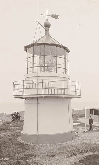
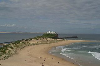
Nobbys Head Light is an active lighthouse on Nobbys Head, a headland on the south side of the entrance to Newcastle Harbour, New South Wales, Australia. An image of the lighthouse is included in the coat of arms of the City of Newcastle.