Related Research Articles

The Hume Highway, including the sections now known as the Hume Freeway and the Hume Motorway, is one of Australia's major inter-city national highways, running for 840 kilometres (520 mi) between Melbourne in the southwest and Sydney in the northeast. Upgrading of the route from Sydney's outskirts to Melbourne's outskirts to dual carriageway was completed on 7 August 2013.

Blackfriars, also known as London Blackfriars, is a central London railway station and connected London Underground station in the City of London. It provides Thameslink services: local, and regional and limited Southeastern commuter services to South East London and Kent. Its platforms span the River Thames, the only one in London to do so, along the length of Blackfriars Railway Bridge, a short distance downstream from Blackfriars Bridge. There are two station entrances either side of the Thames, along with a connection to the London Underground District and Circle lines.

Pacific Highway is a 790-kilometre-long (491 mi) national highway and major transport route along the central east coast of Australia, with the majority of it being part of Australia's Highway 1. The highway and its adjoining Pacific Motorway between Brisbane and Brunswick Heads and Pacific Motorway between Sydney and Newcastle links the state capitals of Sydney in New South Wales with Brisbane in Queensland, approximately paralleling the Tasman Sea and the Coral Sea of the South Pacific Ocean coast, via regional cities and towns like Gosford, Newcastle, Taree, Port Macquarie, Kempsey, Coffs Harbour, Grafton, Ballina, Byron Bay, Tweed Heads and the Gold Coast, which is part of Queensland. Additionally, between Brunswick Heads and Port Macquarie, the road is also signed as Pacific Motorway, but has not been legally gazetted as such.

Hexham is a suburb of the city of Newcastle, about 15 km (9 mi) inland from the Newcastle CBD in New South Wales, Australia on the bank of the Hunter River.

The Hurstbridge Line is a commuter railway line in the city of Melbourne, Victoria, Australia. Operated by Metro Trains Melbourne, it is the city's seventh longest metropolitan railway line at 36.7 kilometres (22.8 mi). The line runs from Flinders Street Station in central Melbourne to Hurstbridge Station in the north-east, serving 28 stations via Clifton Hill, Heidelberg, Macleod, Greensborough, Eltham and Diamond Creek. The line operates for approximately 19 hours a day with 24 hour service available on Friday and Saturday nights. During peak hour, headways of up to 15 minutes are operated with services every 20–30 minutes during off-peak hours. Trains on the Hurstbridge Line run with a two three-car formations of X'Trapolis 100 trainsets.

Orica Limited is an Australian-based multinational corporation that is one of the world's largest providers of commercial explosives and blasting systems to the mining, quarrying, oil and gas, and construction markets, a supplier of sodium cyanide for gold extraction, and a specialist provider of ground support services in mining and tunnelling.

The Main North Line is a major railway in New South Wales, Australia. It runs through Strathfield to Armidale. The line is the main line between Sydney and Armidale. As of 1988, the line closed progressively north of Armidale with services gradually withdrawn till 2004, with the main route between Sydney and Brisbane now the North Coast line. The end of these services marked a significant shift in rail transport in the region, leading to an increased reliance on road transport and altering the dynamics of movement and passenger accessibility between these major cities..

The Pacific Motorway is a motorway in Australia between Brisbane, Queensland, and Brunswick Heads, New South Wales, through the New South Wales–Queensland border at Tweed Heads.

Waratah is a north-western residential suburb of Newcastle, New South Wales, Australia, 6 kilometres (3.7 mi) from Newcastle's central business district and bounded to the north by the Main North railway line. Waratah station was opened in 1858 and is served by NSW TrainLink's Hunter line.

Franklin D. Roosevelt East River Drive, commonly called FDR Drive for short, is a controlled-access parkway on the east side of the New York City borough of Manhattan. It starts near South and Broad Streets, just north of the Battery Park Underpass, and runs north along the East River to the 125th Street / Robert F. Kennedy Bridge interchange, where it becomes Harlem River Drive. All of FDR Drive is designated New York State Route 907L (NY 907L), an unsigned reference route.
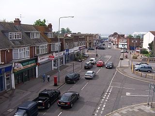
Woolston is a suburb of Southampton, Hampshire, located on the eastern bank of the River Itchen. It is bounded by the River Itchen, Sholing, Peartree Green, Itchen and Weston.

Mayfield is a north-western suburb of Newcastle, New South Wales, which takes its name from Ada May a daughter of the landowner there, John Scholey. Its boundaries are the Hunter River to the north, the Main Northern railway line to the south, the railway line to Newcastle Harbour to the east, and open ground to the west.

The Captain Cook Bridge is a road bridge that carries Taren Point and Rocky Point Roads across the Georges River in southern Sydney, in the state of New South Wales, Australia. The precast prestressed concrete girder bridge crosses near the river mouth as it empties into Botany Bay; and links the St George and Sutherland areas of Sydney. The bridge comprises a dual carriageway with three lanes in each direction of highway grade-separated conditions; and pedestrian and bicycle traffic, via two grade-separated paths. on the eastern and western sides of the bridge.

Tarro is a north-western suburb of the Newcastle City Council local government area in the Hunter Region of New South Wales, Australia. It, and parts of nearby Beresfield, was originally known as Upper Hexham, "lower" Hexham being an older settlement located about 5 kilometres (3 mi) to the east on the Hunter River. The name "Tarro" reportedly means "stone" in an Aboriginal language.
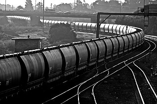
The Hunter Valley Coal Chain (HVCC) is the chain of coal delivery in New South Wales, Australia from coal mines in the Hunter Region to the Port of Newcastle and domestic coal-fired power stations in the Hunter Valley. The HVCC essentially follows the path of the Hunter River travelling south-east from the mining areas in the Hunter Valley to Newcastle.

Tomago is a combined industrial/semi-rural suburb of the Port Stephens local government area in the Hunter Region of New South Wales, Australia. It is located just north of the Hunter River and west of the body of water known as Fullerton Cove. Tomago means "sweet water" in the local Aboriginal language. In 2016 277 lived in Tomago with a median age of 55, 72.7% born in Australia and 80.4% only speaking English at home.

Kooragang is the northernmost and largest suburb of the city of Newcastle, in the Hunter Region of New South Wales, Australia. Dominated by Kooragang Island, the eastern part of the suburb is primarily industrial, while the western part of the suburb consists of nature reserves. Covering an area of 35.4 km2 (13.7 sq mi), at the 2016 census, there were no people living in the suburb.

The Harwood Bridge is a two-lane steel truss bridge which carried the Pacific Highway over the Clarence River in the Northern Rivers region of New South Wales, Australia from 1966 until 2019, when it was replaced by a four-lane 1.5-kilometre-long (4,921 ft) concrete bridge, located 20 metres (66 ft) to its east. The Harwood Bridge has been retained to provide access to Harwood Island.

The Stockton Bridge is a road bridge that carries Nelson Bay Road across the Hunter River, between Kooragang and Stockton in the Hunter Region of New South Wales, Australia. The bridge and Nelson Bay Road serve as the main transport route between Newcastle and the Tilligerry and Tomaree peninsulas in Port Stephens. The bridge carries motor vehicles and a central grade-separated shared cycleway and footpath.
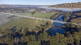
Sheahan Bridge is a dual carriageway bridge over the Murrumbidgee River on the Hume Highway in Gundagai, New South Wales. It is the third longest bridge in New South Wales after the Macleay Valley Bridge and Sydney Harbour Bridge, which at 1.149 km (0.714 mi) is only slightly longer than the Sheahan Bridge's 1.141 km (0.709 mi).
References
- ↑ New Hunter River Bridge Main Roads March 1965 page 65
- ↑ $44 million Tourle Street bridge to open at Mayfield Newcastle Herald 6 May 2009
- ↑ Tourle Street Bridge DECC
- ↑ Tourle St Bridge to be demolished ABC News 25 June 2009
- ↑ Tourle Street Duplication McIlwain
- ↑ Traffic flowing smoothly on new Tourle St Bridge NBN News 22 June 2018
- ↑ Tourle Street duplication at Kooragang almost complete Roads & Maritime Services 22 June 2018
- ↑ Kooragang - duplication of Tourle Street and Cormorant Road Roads & Maritime Services