Bylong Valley Way

Last updated

Bylong Valley Way

BylongValleyWaySign.JPG
General information
TypeRural road
Length138.3 km (86 mi) [1]
Major junctions
Northeast endAUS Alphanumeric Route B84.svg Golden Highway
Sandy Hollow, New South Wales
Southwest endAUS Alphanumeric Route B55.svg Castlereagh Highway
Ilford, New South Wales
Location(s)
Major settlements Baerami, Bylong, Rylstone, Kandos

Bylong Valley Way is a road in New South Wales, Australia linking the Golden Highway near Sandy Hollow to the Castlereagh Highway near Ilford. It is named after the Bylong Valley, through which the road passes.

Contents

Route

In conjunction with the Bathurst-Ilford Road to Bathurst, this route provides a leisurely alternative to going through Sydney to travel between the Hunter Valley and Central Tablelands.

History

The passing of the Main Roads Act of 1924 [2] through the Parliament of New South Wales provided for the declaration of Main Roads, roads partially funded by the State government through the Main Roads Board (later the Department of Main Roads, and eventually Transport for NSW). Main Road No. 208 was declared from Sandy Hollow to Bylong (and continuing west via Wollar to Mudgee, and east via Wybong to the intersection with the Great Northern Highway, at Muswellbrook, [3] and Main Road No. 215 was declared from Bylong via Rylstone to Ilford, [3] on the same day, 8 August 1928.

Sealing

Bylong Valley Way near Coxs Gap and railway line, looking west towards gravel road surface BylongValleyWayGravel.JPG
Bylong Valley Way near Coxs Gap and railway line, looking west towards gravel road surface

The Bylong Valley Way was not fully sealed in the Mid-Western Regional Council area until February 2009. Sealing of the road had been a political issue for decades. At the beginning of 2007, there were four sections of unsealed road totalling 32 kilometres. Two sections were between Coxs Gap and Bylong with only 850 metres of sealed road between them. The other two were south of Bylong on the way towards Rylstone, where two kilometres had been sealed a few years earlier, converting one long unsealed section to two shorter ones.

On 13 December 2006, The federal government announced A$2 million of AusLink funding towards the $4.1 million cost of completion of sealing of the Bylong Valley Way. [4] Under the announced funding arrangement, the Roads & Traffic Authority contributed $900,000 and the Mid-Western Regional Council was to contribute the remaining $1.2 million. [5] The overall cost slightly exceed the budgeted $4.1 million, with the council having to cover the overrun. [6]

The sealing work was carried out by Mid-Western Regional Council and was completed in three stages: [7]

Stage One

  • March 2007 to June 2007
  • Sealing of two sections totalling six kilometres south of Bylong
  • Widening a total of nine kilometres of remaining unsealed road in preparation for sealing in the later stages

Stage Two

  • July 2007 to June 2008
  • Sealing of two remaining unsealed sections south of Bylong totalling 12.42 kilometres
  • Sealing of one section one kilometre long adjacent to existing sealed section east of Bylong
  • Preparatory works for stage three [8]

Stage Three

  • July 2008 to March 2009
  • Completion of sealing, consisting of two sections east of Bylong totalling 12.6 kilometres

National Park access

Phipps Cutting picnic area PhippsCuttingPicnicArea.JPG
Phipps Cutting picnic area

Access to the Wollemi National Park and Goulburn River National Park is available at various points along the road between the Golden Highway and Bylong. Over Coxs Gap, the Bylong Valley Way is flanked by the two national parks. Camping areas are available in the Wollemi National Park on the western side of Coxs Gap, and the Phipps Cutting picnic area between Baerami and Widden Creek provides an entry point for hiking in the Wollemi National Park.

Tourism

Following completion of sealing of the road, The Muswellbrook Chamber of Commerce and Industry created a web site (no longer available by 2020) for the road, to promote it as a tourist route. [9]

The section of the Bylong Valley Way east of Bylong is also part of two separately promoted tourist routes.

A self-drive tour loop route originating in Sandy Hollow, promoted as Upper Hunter Tourist Drive number 4, uses this section of road to travel west, then turns north on other local roads to rejoin the Golden Highway. [10] The Phipps Cutting picnic area is shown as a rest area on that route.

The Tablelands Way tourist route between Canberra and Muswellbrook uses this section of the Bylong Valley Way as part of the route between Mudgee and Muswellbrook. [11]

Bridges

Kirk's Bridge at Baerami after new concrete sections were completed, November 2007 KirksBridgeNew.JPG
Kirk's Bridge at Baerami after new concrete sections were completed, November 2007

Muswellbrook Shire Council

The dilapidated timber sections of the Kirks Bridge, crossing Baerami Creek at Baerami were demolished and were planned to be replaced with new concrete sections by 31 August 2007. [12] Unfortunately, flooding during the 2007 New South Wales storms delayed the work by around a month. The bridge had previously been partially rebuilt, with both buttresses and two spans at one end having been reconstructed in concrete. [13]

Muswellbrook Shire Council maintained a temporary deviation on private property for several years to allow access during bridgework and for heavy vehicles. After the bridge was reopened, that deviation was removed and the land returned to its owner.

The single-lane timber bridge over Widden Creek has also been replaced. Muswellbrook Shire Council had committed to spend $480,000 by 30 June 2007 to Manage the investigation, design and construction works [14] but the discovery of a serious problem on Kirks Bridge saw that money diverted to the more urgent project. Muswellbrook Shire Council subsequently replaced the Widden Creek bridge between January and June 2009 at a cost of approximately A$910,000. [15]

Once the Widden Creek bridge was replaced, the 38 tonne load limit was lifted, allowing heavy vehicles to again use this route.

Mid-Western Regional Council

Mid-Western Regional council plan to replace the single lane Carwell Bridge between Kandos and Ilford between mid-2009 and mid-2010. [16]

Railway

Rail bridge carrying Ulan line over Bylong Valley Way near Coxs Gap RailBridgeOverBylongValleyWay.JPG
Rail bridge carrying Ulan line over Bylong Valley Way near Coxs Gap

The Sandy Hollow-Gulgong railway line and part of the Merriwa railway line, which form the Australian Rail Track Corporation's Ulan line between Muswellbrook and Gulgong, follow the same valleys as the Bylong Valley Way from near the Golden Highway to near Bylong, where the railway line continues west as the road turns south.

The Ulan line crosses the road three times, twice at level crossings and once on a bridge over the road. One level crossing is close to the Golden Highway while the other is close to Bylong. The railway bridge is on the western side of Coxs Gap, between the level crossings.

The Gwabegar railway line crosses the road on at a level crossing the northern side of Rylstone. All three of the level crossings have flashing warning lights but not boom gates.

Major intersections

LGALocationkm [1] miDestinationsNotes
Muswellbrook Sandy Hollow 00.0AUS Alphanumeric Route B84.svg Golden Highway (B84)  Merriwa, Denman Northeastern terminus of road
0.50.31 Sandy Hollow–Gulgong railway line
Goulburn River 0.850.53Bridge over river (no known name)
Muswellbrook Baerami 8.05.0Yarrawa Road  Denman
Baerami Creek 13.98.6Kirks Bridge
Widden Brook 26.216.3Bridge over river (no known name)
Mid-Western Region Bylong 59.637.0 Sandy Hollow-Gulgong railway line
59.637.0Wollar Road  Wollar, Ulan
Rylstone 109.167.8Lue Road  Lue, Mudgee
112.670.0 Gwabegar railway line
114.371.0Fitzgerald Street, to Glen Alice Road  Glen Alice, Capertee
Kandos 120.574.9Cooper Drive  Clandulla T junction
Ilford 138.385.9AUS Alphanumeric Route B55.svg Castlereagh Highway (B55)  Mudgee, Marrangaroo Southwestern terminus of road
1.000 mi = 1.609 km; 1.000 km = 0.621 mi
  •        Route transition

See also

Related Research Articles

<span class="mw-page-title-main">Golden Highway</span> Highway in New South Wales

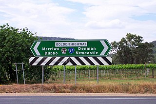
Golden Highway is a 313-kilometre (194 mi) highway, located in the Hunter and Orana regions of New South Wales, Australia. It runs eastwards from Dubbo towards Newcastle on the coast, allowing road transport to avoid travelling over the Blue Mountains to Sydney, and is designated route B84.

<span class="mw-page-title-main">Main North railway line, New South Wales</span> Railway line in New South Wales, Australia

The Main North Line is a major railway in New South Wales, Australia. It runs through the Central Coast, Hunter and New England regions. The line was the original main line between Sydney and Brisbane, however this required a change of gauge at Wallangarra. As of 1988, the line closed progressively north of Armidale with services gradually withdrawn till 2004, with the main route between Sydney and Brisbane now the North Coast line.

<span class="mw-page-title-main">Kennedy Highway</span> Highway in Queensland, Australia

The Kennedy Highway is a highway in northern Queensland, Australia. It runs as National Route 1 for approximately 243 km from Smithfield, on the northern outskirts of Cairns, to the Gulf Developmental Road in the vicinity of Forty Mile Scrub and Undara Volcanic national parks. South of this junction, the road continues as the Kennedy Developmental Road to Boulia about 936 kilometres away, via Hughenden. West of the junction, National Route 1 continues as the Gulf Developmental Road to Normanton.

<span class="mw-page-title-main">Mid-Western Regional Council</span> Local government area in New South Wales, Australia

The Mid-Western Regional Council is a local government area in the Central West region of New South Wales, Australia. The area is located adjacent to the Castlereagh Highway that passes through the middle of the area in an approximate southeast–northwest direction.

<span class="mw-page-title-main">Bylong Valley</span>

The Bylong Valley is a winding but relatively flat valley that crosses the Great Dividing Range between the Goulburn River National Park and Wollemi National Park, west of the upper Hunter Region in New South Wales, Australia.

Bathurst-Ilford Road is a 72.0-kilometre (44.7 mi) New South Wales country road linking Ilford to the regional hub of Bathurst.

<span class="mw-page-title-main">Rylstone, New South Wales</span> Town in New South Wales, Australia

Rylstone is a small town in New South Wales, Australia, in the Central Tablelands region within the Mid-Western Regional Council local government area. It is located on the Bylong Valley Way road route. At the 2021 census, Rylstone had a population of 904.

Kandos is a small town in the Central Tablelands of New South Wales, Australia, within Mid-Western Regional Council. The area is the traditional home of the Dabee tribe, of the Wiradjuri people. The town sits beneath Cumber Melon Mountain, in a district formerly known as Coomber. Kandos shares its locality, employment and infrastructure with the neighbouring town Rylstone, 6 kilometres away. At the 2021 census, Kandos had a population of 1263.

<span class="mw-page-title-main">Sandy Hollow, New South Wales</span>

Sandy Hollow is a small rural town in New South Wales, Australia in Muswellbrook Shire. The town is located on the Golden Highway in the far west of the Upper Hunter Region, about 260 km north of Sydney.

<span class="mw-page-title-main">Bylong, New South Wales</span> Town in New South Wales, Australia

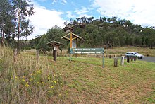
Bylong is a village in New South Wales, Australia, in the Mid-Western Regional Council. It is located on the Bylong Valley Way.

<span class="mw-page-title-main">Muswellbrook Shire</span> Local government area in New South Wales, Australia

Muswellbrook Shire is a local government area in the Upper Hunter region of New South Wales, Australia. The Shire is situated adjacent to the New England Highway and the Hunter railway line.

<span class="mw-page-title-main">Baerami, New South Wales</span> Town in New South Wales, Australia

Baerami is a locality in the Muswellbrook Shire in the Upper Hunter region of New South Wales, Australia.

<span class="mw-page-title-main">Merriwa railway line</span>

The Merriwa railway line is in the Hunter Valley of Northern New South Wales, Australia.
The line branches from the Main North line at Muswellbrook and travels southwest to Denman then generally northwest through Sandy Hollow to the town of Merriwa, a distance of approximately 80 kilometres (50 mi). The line was completed to Merriwa on 29 October 1917, however the section north west of Sandy Hollow closed in 1988.
There are 3 mines, Bengalla & Mt Pleasant, just southwest & west of Muswellbrook & Mangoola, 1/2 way to Denman with Ballon Loops of this line & a number of Passing Sidings have been built with the traffic to / from the 3 mines @ Ulan near Gulgong.
The section between Muswellbrook and Sandy Hollow, combined with the Sandy Hollow – Gulgong railway line forms the Australian Rail Track Corporation's Ulan line between Muswellbrook and Gulgong on the Gwabegar railway line.

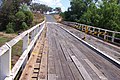
The Sandy Hollow–Gulgong railway line is a railway line in eastern New South Wales, Australia. The line forms a cross country connection from the Main North line in the Upper Hunter region to the Gwabegar line in the Central West region. The line is approximately 125 kilometres (78 mi) in length. From the Gwabegar line, trains can then ultimately reach the Main West line creating a circuitous bypass of Sydney for freight traffic heading between the west and north of New South Wales. The line was opened in 1985.

<span class="mw-page-title-main">State Highway 38 (New Zealand)</span> Road in New Zealand

State Highway 38 is a road in the North Island of New Zealand that starts from SH 5 near Waiotapu, and ends at Wairoa, where it connects to SH 2. It is the shortest connection from the central North Island (Rotorua) to the East Coast (Gisborne), but it is not often used as such. Large parts of the road are narrow and winding, and about 74 kilometres (46 mi) of the road is unsealed. Travel on this highway takes roughly four hours.

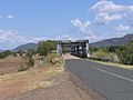
Widden is a locality in New South Wales, Australia, in the Muswellbrook Shire. It is located on the Bylong Valley Way. The Sandy Hollow- Gulgong goods railway line passes through the locality.

<span class="mw-page-title-main">Burke Developmental Road</span> Road in Queensland, Australia

The Burke Developmental Road is a Queensland (Australia) developmental road. It links Cloncurry and Normanton in a south–north direction, then turns to the north-east 30 km (19 mi) north of Normanton for 230 km (140 mi) before turning south-east till Dimbulah, where it becomes the Mareeba Dimbulah Road.

Gladstone–Monto Road is a 132 kilometres (82 mi) road route in the Gladstone and North Burnett regions of Queensland, Australia. The entire route is signed as State Route 69.

Richmond–Croydon Road is a continuous 360 kilometres (220 mi) road route in the Richmond, Croydon and Etheridge local government areas of Queensland, Australia. It is part of the shortest route from the Croydon / Georgetown area to Winton and Longreach. It is also part of the inland freight network linking cattle properties to major freight routes on the Landsborough and Flinders highways.

Baerami Creek is a locality in the Muswellbrook Shire in the Upper Hunter region of New South Wales, Australia. Part of the locality lies in a part of the valley of the watercourse of the same name, Baerami Creek.

References

  1. 1 2 Google (22 August 2022). "Bylong Valley Way" (Map). Google Maps . Google. Retrieved 22 August 2022.
  2. State of New South Wales, An Act to provide for the better construction, maintenance, and financing of main roads; to provide for developmental roads; to constitute a Main Roads Board Archived 11 August 2022 at the Wayback Machine 10 November 1924
  3. 1 2 "Main Roads Act, 1924-1927". Government Gazette of the State of New South Wales . No. 110. National Library of Australia. 17 August 1928. pp. 3814–20. Retrieved 1 August 2022.
  4. "Auslink Strategic Regional Program - Projects selected for funding" (PDF). Archived from the original (PDF) on 29 August 2007. Retrieved 9 February 2007.
  5. NSW Nationals announcement of funding for Bylong Valley Way
  6. http://www.midwestern.nsw.gov.au/files/Executive/Attachment_-_Corporate.pdf Mid-Western Regional Council 2008/2009 Management Plan, monthly report January 2009
  7. Auslink details of project for sealing of Bylong Valley Way AusLink
  8. Mid-Western Regional Council - Quarterly Review, June 2008
  9. "The Bylong Valley Way". Archived from the original on 15 March 2018.{{cite web}}: CS1 maint: unfit URL (link)
  10. "Sandy Hollow self-drive tour loop".
  11. http://www.tablelandsway.com.au/ The Tablelands Way web site
  12. "Muswellbrook Shire Council tender documents for bridge construction". Archived from the original on 27 September 2007. Retrieved 9 March 2007.
  13. Muswellbrook Shire Council 2004-2005 capital expenditure report
  14. "Muswellbrook Shire Council 2006-2007 management plan" (PDF). Archived from the original (PDF) on 21 February 2007. Retrieved 29 April 2007.
  15. Cordell Connect - Project : WIDDEN CREEK BRIDGE
  16. Mid-Western Regional Council 2007-2008 management plan

Commons-logo.svg Media related to Bylong Valley Way at Wikimedia Commons