Clandulla, New South Wales

Last updated

Clandulla
New South Wales
Australia New South Wales relief location map.png
Red pog.svg
Clandulla
Coordinates 32°55′1″S149°57′4″E / 32.91694°S 149.95111°E / -32.91694; 149.95111 Coordinates: 32°55′1″S149°57′4″E / 32.91694°S 149.95111°E / -32.91694; 149.95111
Population197 (2016 census) [1]
Postcode(s) 2848
Elevation716 m (2,349 ft)
LGA(s) Mid-Western Regional Council
State electorate(s) Bathurst
Federal division(s) Calare

Clandulla is a village in New South Wales, Australia, within the Mid-Western Regional Council, about 225 kilometres north-west of Sydney. At the 2016 census Clandulla and the surrounding rural district had a population of 197, living in 61 private dwellings. The township and district also included 22 unoccupied private dwellings. [1] Clandulla is bounded to the west and north by the Clandulla State Forest (with an area of about 1,400 hectares).

Contents

The village, which essentially grew around the railway station at the locality, has had several name changes during its history. From about 1884 the settlement was named Calwell (even though the railway station was named Ilford, after the older township in the district eight miles to the south-west on the Sydney Road). By about 1905 both the village and the railway station had been renamed Clandulla. [2]

History

The parish of Clandulla within the county of Roxburgh (which had been named by the mid-1860s) includes the locality of present-day Clandulla village in the north-west corner of the parish. [3] [4]

In September 1881 William Hawkins was granted a publican's license for the White Horse Hotel located at “Flatlands, Clandulla”. [5] In November 1881 it was reported that it was “proposed to establish” a public school at “Clandulla, near Ilford”. [6]

In June 1884 the railway branch line connecting Capertee to Wallerawang was extended through to Rylstone. [7] The railway extension passed through the site of the present-day village, by-passing the established settlement of Ilford eight miles to the south-east on the Sydney Road. A railway station was built at the location and the railway authorities named it 'Ilford' despite the distance between Ilford village and the new station. The railway station had been constructed by February 1884 when a correspondent made the observation that "the Ilford station house… seems too pretentious for the likely public requirements there". [8]

In October 1885 it was notified that Crown Lands were "declared to be reserved and set apart" as a site for the village at Carwell. The land set aside for Carwell village was in the vicinity of Ilford railway station. [9]

The railway station was named Ilford until 1900, when it was renamed Mornington. Three years later it was briefly renamed Carwell. [2] In May 1905 it was notified that “the Railway Commissioners and the postal authorities” had agreed to change the name of Carwell railway station to Clandulla. [10]

In August 1925 it was reported that "here and there at Clandulla there are evidences of the little village 'kicking its way through the shell'". Additional homes in the village were "springing up in consequence of recent subdivision sales" (which were probably stimulated by the construction of the nearby Charbon cement works). [11]

Shale oil

When the area was known as Mornington, in 1900-1901, it was the site of a short-lived shale mining and retorting operation, run by the Mornington Proprietary Oil Company. Retorts of a novel 'lead bath' design were erected and a road constructed to their site. Experimental distillation of oil took place, but the 'lead bath' retorts were unsuitable—the low temperature of operation could not recover enough of the valuable ammonia by-product—and the quality of the carbonaceous shale—not torbanite, or 'kerosene shale' as it was then known—at Mornington was too poor to extract its oil content economically, by any available method. The site was abandoned, and the company was in liquidation by mid 1902. [12] [13] [14] [15] [16]

Cement works

In March 1924 shares in the Standard Portland Cement Company Ltd. were offered for public sale. The company was “formed to establish works for the manufacture of Portland cement” at a location north of Clandulla village “and to acquire from Cement Products Ltd., all rights in limestone leases, freeholds, contracts, etc.”. [17] At the time of the share float the Standard Portland Cement Company reached an agreement with the NSW State government to supply 50 thousand tons of cement annually (at £2 17s. 6d. a ton), with supply to commence two years after the contract was signed. [18] An article published in October 1924 described the development of the cement works being built six kilometres north of Clandulla village (half-way between Clandulla and Kandos). The industrial complex and associated facilities for workers was to be called 'Charbon' (the French word for 'coal'). It was expected “the new works will reach the stage of cement production in about 18 months”. Limestone deposits for the cement-making process were “situated nearby on Carwell Creek”. [19] Over 150 men were employed during the construction phase. [20] The “first train load of cement” was despatched from the Charbon works in January 1927. It was reported that “the railway authorities” were constructing a platform near the Charbon works as Clandulla was considered to be “rather far away” to effectively serve the cement works. [21]

In late 1923 shares in a company called the Clandulla Cement Ltd. were offered for public sale. The company proposed to acquire “certain limestone and coal-bearing lands… at Clandulla and near Watson’s Cutting” (alongside the railway line south of Clandulla) in order “to establish Portland cement works and other enterprises”. [22] In January 1925, with the cement works under construction, Albert Dalwood, the chairman of directors of Clandulla Cement Ltd., stated in an interview that “the situation of the works is a unique one, owing to enormous deposits of all the requisite raw materials, lime stone, shale, coal and water being within half a mile of the factory site, providing exceptional facilities for production at low cost”. [23]

In August 1926 it was reported that the Great Western Cement Company “has taken over the Clandulla Cement Co.’s lands at Clandulla’. The company intended to “open up collieries and quarries, and to manufacture cement”, as well as constructing “a branch line of railway from the collieries”. [24] In June 1929 it was reported that “the proposed new town to be established on the Great Western Cement Company’s property at Clandulla” would be called 'Concrete'. [25] In March 1930 a reader's question about the Great Western Cement Company was published in the Truth newspaper asking whether the company was “a proper going concern”. The published answer stated that although the company was registered in 1926 and “over £150,000 capital” had been subscribed, “it is still in the non-producing stage”. The newspaper added that “it is about time the company got to work in the interests of its shareholders”. [26] The grand plans for a cement works south of Clandulla were eventually abandoned. By the end of 1930 the Great Western Cement Company had applied to lease 30 acres at Bunnerong in south-east Sydney in order to erect “works for the manufacture of carbon dioxide and lime products”. [27]

Geology

Clandulla village sits above the geological formation known as Clandulla Limestone which consists of limestone and dolomite, as well as carbonaceous shale. The Clandulla Limestone formation has a maximum thickness of 170 metres and is part of the extensive Lachlan Orogen (Fold Belt). The Lachlan Fold Belt was formed "by deep-marine sediments with basic volcanics", with sedimentation extending over a vast time period from the Cambrian to the Carboniferous. [28] [29]

See also

Related Research Articles

Capertee, New South Wales Town in New South Wales, Australia

Capertee pronounced is a village 46 km north of Lithgow, New South Wales, Australia. It is on an elevated site above the Capertee Valley. In 2016, the township had a population of 145 people. The Castlereagh Highway links Capertee with Lithgow to the south and Mudgee to the north. The township is surrounded by National Parks and grazing land. Principal employment is in coal mining, farming and tourism-related services. The Capertee Valley forms a part of the catchment area of the Hawkesbury River, but the village lies very close to the Great Divide watershed, with the Turon River catchment nearby to its west.

Ilford, New South Wales Town in New South Wales, Australia

Ilford is a village in New South Wales, Australia, beside the Crudine River within the Mid-Western Regional Council. It is located on the Castlereagh Highway, about 220 kilometres north-west of Sydney. At the 2016 census Ilford and the surrounding rural district had a population of 187, living in 65 private dwellings. The district also included 43 unoccupied private dwellings. Ilford was named after the English township of Ilford, from where early residents of the locality originated.

Central West (New South Wales) Region in New South Wales, Australia

The Central West is a region of New South Wales, Australia. The region is geographically in central and eastern New South Wales, in the area west of the Blue Mountains, which are west of Sydney. It has an area of 63,262 square kilometres (24,426 sq mi). The region also includes the sub-region known as the Central Tablelands, located in the eastern part of the region. The region known as the Orana, which includes the area surrounding Dubbo is commonly classed as being a part of the Central West also.

Bylong Valley Way

Bylong Valley Way is a New South Wales country road linking the Golden Highway near Sandy Hollow to the Castlereagh Highway near Ilford. It is named after the Bylong Valley, through which the road passes.

Rylstone, New South Wales Town in New South Wales, Australia

Rylstone is a small town in New South Wales, Australia, in the Central Tablelands region within the Mid-Western Regional Council local government area. It is located on the Bylong Valley Way road route. At the 2016 census, Rylstone had a population of almost 650 people.

Kandos is a small town in the Central Tablelands of New South Wales, Australia, within Mid-Western Regional Council. The area is the traditional home of the Dabee tribe, of the Wiradjuri people. The town sits beneath Cumber Melon Mountain, in a district formerly known as Coomber. Kandos shares its locality, employment and infrastructure with the neighbouring town Rylstone, six kilometres away. Kandos had a population of 1261 at the 2016 census and Rylstone 644.

Marrangaroo is a village in the Central West of New South Wales, Australia in the City of Lithgow.

Portland is a town in the Central Tablelands of New South Wales, Australia. At the 2016 census, Portland had a population of 2,424 people. The town was named after Australia's first cement works.

Gwabegar railway line

The Gwabegar railway line is a railway line in the Central West and North West Slopes of New South Wales, Australia, which passes through the towns of Mudgee, Gulgong, Dunedoo, Coonabarabran and terminates at Gwabegar.

Samuel Nicholls Australian politician

Samuel Robert Nicholls was an Australian politician. He was an Australian Labor Party member of the Australian House of Representatives from 1917 to 1922, representing the electorate of Macquarie.

Hartley Vale, New South Wales Town in New South Wales, Australia

Hartley Vale is a small village in the Blue Mountains area of New South Wales, Australia. It is approximately 150 kilometres west of Sydney and 12 kilometres south-east of Lithgow. It is in the local government area of the City of Lithgow.

William Wall (Australian politician) Australian politician

William Chandos Wall was an Australian politician. He was also a prospector, geologist, minerals surveyor, commission / mining agent, inventor and a quarry and mine operator before and after entering politics. In June 1886 he was elected to the New South Wales Legislative Assembly to succeed the former NSW premier Sir John Robertson KCMG as one of the members for Mudgee. In 1894 Wall transferred to Rylstone and in July 1895 he lost the Rylstone seat.

Kerosene Vale is a historic locality within the City of Lithgow Local Government Area of New South Wales, Australia. Kerosene Vale lies near Lidsdale and Wallerawang. It is considered part of Lidsdale for census purposes. It should not be confused with Hartley Vale, another locality with a history of shale oil production, which is also within the City of Lithgow. The name Kerosene Vale is now only used infrequently.

Glen Davis Shale Oil Works Oil extraction plant

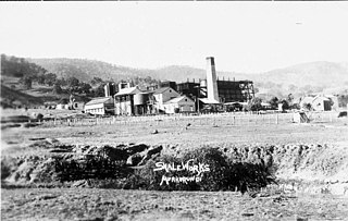
The Glen Davis Shale Oil Works was a shale oil extraction plant, in the Capertee Valley, at Glen Davis, New South Wales, Australia, which operated from 1940 until 1952. It was the last oil-shale operation in Australia, until the Stuart Oil Shale Project in the late 1990s. For the period of 1865–1952, it provided one fifth of the shale oil produced in Australia.

Wallerawang railway station

The Wallerawang railway station is a heritage-listed disused railway station located on the Main Western line in Wallerawang, City of Lithgow, New South Wales, Australia. It is also known as Wallerawang Railway Station and yard group. The property was added to the New South Wales State Heritage Register on 2 April 1999.

Rylstone railway station, New South Wales Historic site in New South Wales, Australia

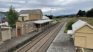
Rylstone railway station is a heritage-listed former railway station on the Gwabegar railway line at Rylstone, Mid-Western Regional Council, New South Wales, Australia. Although it closed to regular passenger services in 1985, it is planned to restore a tourist service between Kandos and Rylstone in late 2018. The property was added to the New South Wales State Heritage Register on 2 April 1999.

Rylstone Shire was a local government area in the Central West region of New South Wales, Australia.

Torbane, New South Wales Former location in New South Wales

Torbane was a privately-owned village lying within the area now known as Capertee, in the Local Government Area of the City of Lithgow, within the Central West region of New South Wales, Australia. There was also another village, Airly, nearby. Both villages were associated with the mining and processing of oil shale. The mine associated with Torbane was known as the New Hartley Mine. and that associated with Airly was known as the Glenowlan Mine. Both Torbane and Airly are now ghost towns.

John Fell (industrialist) Scottish-born Australian industrialist

John Wilson Fell (1862–1955) was an industrialist involved in the shale oil operations at Newnes, New South Wales and the establishment of two early oil refineries, on Gore Bay at Greenwich and at Clyde, both suburbs of Sydney. He was the principal of John Fell & Company and was, for many years, the Managing Director of Commonwealth Oil Corporation, which he revived from receivership.

British Australian Oil Company Former shale oil company of Australia

The British Australian Oil Company Limited was a British-owned company—incorporated in 1910—that mined oil shale and produced shale oil and refined oil products, in New South Wales, Australia, during the years from 1911 to 1915.

References

  1. 1 2 "Clandulla". 2016 Census Quick Stats. Australian Bureau of Statistics. Retrieved 21 March 2021.
  2. 1 2 Where did the name Clandulla come from?, Mudgee Guardian, 27 May 2015.
  3. Parish of Clandulla, NSW Department of Lands, 1958.
  4. Rylstone (at the Police Office), Sydney Morning Herald, 19 April 1865, page 2.
  5. Rylstone District, New South Wales Government Gazette, 23 September 1881 (Issue No. 374), page 4840.
  6. Evening News (Sydney), 23 November 1881, page 6.
  7. ’The Wallerawang - Gwabegar Branch Line’, Australian Railway Historical Society Bulletin , January 1968 & August 1968
  8. The Mudgee Railway Works, Daily Telegraph (Sydney), 22 February 1884, page 8.
  9. Site for a Village at Carwell, New South Wales Government Gazette, 20 October 1885 (Issue No. 491 Supplement), page 6872.
  10. A Change of Name, Mudgee Guardian and North-Western Representative, 11 May 1905, page 10.
  11. After Forty Years, Mudgee Guardian and North-Western Representative, 27 August 1925, page 15.
  12. Carne, J. E. (1903). The Kerosene Shale Deposits of New South Wales. Sydney: Department of Mines and Agriculture, New South Wales. pp. 38, 249, 250, 251.
  13. "A HUGE CASTING". Sydney Morning Herald. 12 February 1900. p. 5. Retrieved 3 July 2022.
  14. "MINING INTELLIGENCE". Sydney Morning Herald. 15 January 1901. p. 9. Retrieved 4 July 2022.
  15. "THE WORKS AT PORTLAND". Lithgow Mercury. 19 February 1901. p. 1. Retrieved 4 July 2022.
  16. "Advertising". Sydney Morning Herald. 20 June 1902. p. 3. Retrieved 4 July 2022.
  17. Standard Portland Cement, Sydney Morning Herald, 26 March 1924, page 17.
  18. Government Buys Cement, Tweed Daily (Murwillumbah), 18 March 1924, page 3.
  19. The Charbon Cement Project: Big Proposition Now Commenced, Lithgow Mercury, 31 October 1924, page 3.
  20. Charbon Cement Works: Big Progress Made, Lithgow Mercury, 31 August 1925, page 2.
  21. Cement Despatched: Charbon Fills First Order, Lithgow Mercury, 20 January 1927, page 2.
  22. Clandulla Cement, Lithgow Mercury, 5 December 1923, page 1.
  23. Clandulla Cement Ltd., Sunday Times (Sydney), 25 January 1925, page 2.
  24. Clandulla Cement, Lithgow Mercury, 18 August 1926, page 2.
  25. “Concrete”: New Town on Mudgee Line, Lithgow Mercury, 28 June 1929, page 4.
  26. “Truth’s” Service Bureau: Financial, Truth (Sydney), 9 March 1930, page 9.
  27. Great Western Portland Co., The Age (Melbourne), 11 September 1930, page 12.
  28. "Clandulla Limestone". Australian Stratigraphic Units Database. Geoscience Australia. Retrieved 23 March 2021.
  29. "Lachlan Orogen". Australian Stratigraphic Units Database. Geoscience Australia. Retrieved 23 March 2021.