
The Hume Highway, including the sections now known as the Hume Freeway and the Hume Motorway, is one of Australia's major inter-city national highways, running for 840 kilometres (520 mi) between Melbourne in the southwest and Sydney in the northeast. Upgrading of the route from Sydney's outskirts to Melbourne's outskirts to dual carriageway was completed on 7 August 2013.

Princes Highway is a major road in Australia, extending from Sydney via Melbourne to Adelaide through the states of New South Wales, Victoria and South Australia. It has a length of 1,941 kilometres (1,206 mi) or 1,898 kilometres (1,179 mi) via the former alignments of the highway, although these routes are slower and connections to the bypassed sections of the original route are poor in many cases.

Pacific Highway is a 790-kilometre-long (491 mi) national highway and major transport route along the central east coast of Australia, with the majority of the highway being part of Australia's Highway 1. The highway and its adjoining Pacific Motorway between Brisbane and Brunswick Heads and Pacific Motorway between Sydney and Newcastle links the state capitals of Sydney in New South Wales with Brisbane in Queensland. It approximately parallels the Tasman Sea and the Coral Sea of the South Pacific Ocean coast. Additionally, between Brunswick Heads and Port Macquarie, the road is also signed as Pacific Motorway, but has not been legally gazetted as such.

The Macleay River is a river that spans the Northern Tablelands and Mid North Coast districts of New South Wales, Australia.

The Westlink M7 is a 40-kilometre (25 mi) tolled urban motorway in Sydney, New South Wales that is part of the Sydney Orbital Network. Owned by the NorthWestern Roads (NWR) Group, it connects three motorways: the M5 South-West Motorway at Prestons, the M4 Western Motorway at Eastern Creek, and the M2 Hills Motorway at Baulkham Hills.

The Roads & Traffic Authority (RTA) was an agency of the Government of New South Wales responsible for major road infrastructure, licensing of drivers, and registration of motor vehicles. The RTA directly managed state roads and provided funding to local councils for regional and local roads. In addition, with assistance from the federal government, the RTA also managed the NSW national highway system. The agency was abolished in 2011 and replaced by Roads & Maritime Services.

Kempsey is a town in the Mid North Coast region of New South Wales, Australia and is the council seat for Kempsey Shire. It is located roughly 16.5 kilometres inland from the coast of the Pacific Ocean, on the Macleay Valley Way near where the Pacific Highway and the North Coast railway line cross the Macleay River. It is roughly 430 kilometres north of Sydney. As of June 2018 Kempsey had a population of 15,309 (2018).

M1 Pacific Motorway is a 127-kilometre motorway linking Sydney to Newcastle via the Central Coast and Hunter regions of New South Wales. Formerly known but still commonly referred to by both the public and the government as the F3 Freeway, Sydney–Newcastle Freeway, and Sydney–Newcastle Expressway, it is part of the AusLink road corridor between Sydney and Brisbane.
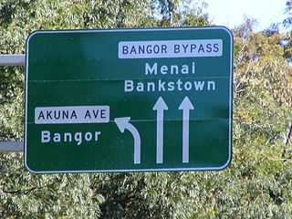
Bangor Bypass is a road in New South Wales, Australia, between New Illawarra Road and River Road, bypassing Bangor and Menai. Completed in February 2005, it replaced Menai Road as the main road between A6 and River Road, alleviating traffic on Menai Road and increasing travel speed through Bangor and Menai. It also acts as a western extension of River Road and Woronora Bridge, which was completed four years earlier in 2001. A section of New Illawarra Road north of the bypass was also completed as part of the project, linking the bypass directly to Alfords Point Road.
AusLink is a former Government of Australia land transport funding program, that operated between June 2004 and 2009. The former program was administered by the former Department of Transport and Regional Services. In 2009, the program was replaced with the Nation Building Program under the Nation Building Program Act 2009. The Nation Building Program was administered by the Department of Infrastructure and Transport and that program was replaced by The National Land Transport Network, as determined by the Minister for Infrastructure and Regional Development under the National Land Transport Act 2014.
The Kempsey bus crash killed 35 people and injured 41 on the Pacific Highway near Kempsey, New South Wales on 22 December 1989 when a McCafferty's Coaches coach operating an express service from Brisbane to Sydney collided head on with a Trans City Express coach operating an express service from Sydney to Brisbane. It remains the worst road crash in Australia.
M2 Hills Motorway is a 19.3-kilometre (12.0 mi) tolled urban motorway in Sydney, New South Wales that is part of the Sydney Orbital Network and the National Highway west of Pennant Hills Road. Owned by toll road operator Transurban, it forms majority of Sydney's M2 route, with the Lane Cove Tunnel constituting the rest of the M2 route.

Kempsey Shire is a local government area in the Mid North Coast region of New South Wales, Australia.

The Hunter Expressway is a 39.5-kilometre (24.5 mi) long controlled-access highway in New South Wales, Australia. It was previously known as the F3 to Branxton link or Kurri Kurri Corridor during the planning stage. It has two lanes in each direction, running generally north west from the Pacific Motorway at the Newcastle Link Road interchange to the eastern end of the Belford Bends Deviation on the New England Highway north of Branxton. The road allows traffic to bypass the Maitland area, Lochinvar, Greta and Branxton. The expressway opened on 22 March 2014.

The Harwood Bridge is a two-lane steel truss bridge which carried the Pacific Highway over the Clarence River in the Northern Rivers region of New South Wales, Australia from 1966 until 2019, when it was replaced by a four-lane 1.5-kilometre-long (4,921 ft) concrete bridge, located 20 metres (66 ft) to its east. The Harwood Bridge has been retained to provide access to Harwood Island.
Frederickton is a town on the Macleay River, New South Wales. Located about 6 km NE by N of Kempsey and about 7 km W by S of Smithtown. It is roughly 436 kilometres north of Sydney. The Macleay Valley Bridge, the longest bridge on the Pacific Highway commences just to the East of town.
The Djangadi people, also spelt Dhungatti, Dainggati, Tunggutti or Dunghutti are an Aboriginal Australian people resident in the Macleay Valley of northern New South Wales.
The Macleay Valley Way is a road in the Mid North Coast region of New South Wales that connects the Pacific Highway to Kempsey and Frederickton. It runs along a former section of the Pacific Highway that was bypassed by a newer alignment between 2013 and 2016.
Sheahan Bridge is a dual carriageway bridge over the Murrumbidgee River on the Hume Highway in Gundagai, New South Wales. It is the third longest bridge in New South Wales after the Macleay Valley Bridge and Sydney Harbour Bridge, which at 1.149 km (0.714 mi) is only slightly longer than the Sheahan Bridge's 1.141 km (0.709 mi).
