
Pacific Highway is a 790-kilometre-long (491 mi) national highway and major transport route along the central east coast of Australia, with the majority of it being part of Australia's Highway 1. The highway and its adjoining Pacific Motorway between Brisbane and Brunswick Heads and Pacific Motorway between Sydney and Newcastle links the state capitals of Sydney in New South Wales with Brisbane in Queensland, approximately paralleling the Tasman Sea and the Coral Sea of the South Pacific Ocean coast, via regional cities and towns like Gosford, Newcastle, Taree, Port Macquarie, Kempsey, Coffs Harbour, Grafton, Ballina, Byron Bay, Tweed Heads and the Gold Coast, which is part of Queensland. Additionally, between Brunswick Heads and Port Macquarie, the road is also signed as Pacific Motorway, but has not been legally gazetted as such.
Hastings River, an open and trained intermediate wave dominated barrier estuary, is located in the Northern Tablelands and Mid North Coast districts of New South Wales, Australia.

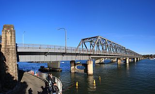
The Iron Cove Bridge is a heritage-listed road bridge that carries Victoria Road (A40) across Iron Cove, between the Sydney suburbs of Drummoyne and Rozelle. Iron Cove is an arm of Sydney Harbour.
Tom Uglys Bridge are two road bridges, completed in 1929 and 1987, that carry the Princes Highway across the Georges River in southern Sydney, in the state of New South Wales, Australia. The bridges link the St George area at Blakehurst to the Sutherland Shire at Sylvania. Tom Uglys Bridge is one of six major road crossings of Georges River.

The Mooney Mooney Bridge, officially the Mooney Mooney Creek Bridge, and popularly known as The NSW Big Dipper Bridge, is a twin cantilever bridge that carries the Pacific Motorway (M1) across Mooney Mooney Creek, located near Mooney Mooney in the Brisbane Water National Park on the Central Coast of New South Wales, Australia. The concrete box girder bridge was opened on 14 December 1986 by the Prime Minister of Australia, Bob Hawke, and is owned and maintained by Transport for NSW, an agency of the Government of New South Wales.
De Burghs Bridge is a road bridge that carries the Lane Cove Road, part of the A3, across the Lane Cove River in Macquarie Park, Sydney, Australia. The bridge stretches from Macquarie Park in the south to West Pymble in the north.

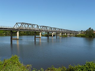
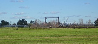
The Harwood Bridge is a two-lane steel truss bridge which carried the Pacific Highway over the Clarence River in the Northern Rivers region of New South Wales, Australia from 1966 until 2019, when it was replaced by a four-lane 1.5-kilometre-long (4,921 ft) concrete bridge, located 20 metres (66 ft) to its east. The Harwood Bridge has been retained to provide access to Harwood Island.

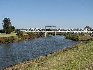
The Peats Ferry Bridge is a steel truss bridge that carries the Pacific Highway (B83) across the Hawkesbury River, between Kangaroo Point and Mooney Mooney Point, located 40 kilometres (25 mi) north of Sydney in New South Wales, Australia. The bridge carries the Hornsby to Kariong section of highway, while the adjacent Brooklyn Bridge carries the Pacific Motorway (M1).
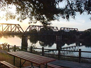
The Martin Bridge is a road bridge that carries the Manning River Drive across the Manning River in Taree, in the Mid North Coast region of New South Wales, Australia. In 2010, the bridge was added to New South Wales State Heritage Register.

The Mungindi Bridge is a road bridge that carries the Carnarvon Highway across the Barwon River on the Queensland/New South Wales border at Mungindi, New South Wales, Australia.

The Bethanga Bridge is a steel truss road bridge that carries the Riverina Highway across Lake Hume, an artificial lake on the Murray River in Australia. The dual heritage-listed bridge crosses the border between the Australian states of New South Wales and Victoria, linking the Victorian towns of Bellbridge and Bethanga with the regional New South Wales city of Albury.

The Murray River railway bridge is a heritage-listed Australian railway bridge over the Murray River on the Main Southern line south of Albury in the City of Albury, New South Wales, and on the North Eastern line north of Wodonga in Victoria. The bridge was designed by John Whitton and built from 1883 to 1884 by J. S. Bennett, with iron work supplied by Westwood, Baillie, England. It is also known as the Rail Bridge over Murray River, Albury–Wodonga and the Albury Lattice Railway Bridge and Murray River Underbridge. The bridge is owned by RailCorp, and maintained by the Australian Rail Track Corporation as part of its lease of the line. It was added to the New South Wales State Heritage Register on 2 April 1999, and added to the Register of the National Estate on 18 April 1989.

The Dubbo rail bridge over Macquarie River – Wambuul is a heritage-listed railway bridge on the Main Western line across the Macquarie River, located west of the Dubbo central business district in New South Wales, Australia. It was designed by John Whitton as the Engineer-in-Chief for the New South Wales Government Railways. The bridge was built during 1884 by Benjamin Barnes, with ironwork by Cochrane & Co, Middlesborough, England. The railway bridge is also known as the Dubbo Lattice Railway Bridge. The property is owned by Transport Asset Holding Entity, an agency of the Government of New South Wales. The bridge was added to the New South Wales State Heritage Register on 2 April 1999 and was listed on the Register of the National Estate on 18 April 1989.

The Murray River bridge is a heritage-listed road bridge that carries Main Road across the Murray River located at Barham in the Murray River Council local government area of New South Wales, Australia. It was designed by Department of Public Works and built in 1904 by John Monash. The bridge is also known as the Barham Bridge over Murray River and the Barham bridge. The bridge is owned by the Murray River Council and was added to the New South Wales State Heritage Register on 20 June 2000.

The Tooleybuc Bridge is a dual heritage-listed road bridge that carries Tooleybuc Road across the Murray River, located in Tooleybuc, New South Wales, Australia. It was built in 1925. The bridge is owned by the Transport for NSW, and is also called the Tooleybuc Bridge over Murray River. The bridge was added to the New South Wales State Heritage Register on 20 June 2000 and the Victorian Heritage Register on 10 July 2008.
The Dunmore Bridge is a heritage-listed road bridge that carries Clarence Town Road across the Paterson River in Woodville, New South Wales, Australia. It was designed by Percy Allan and built in 1899 by Morpeth contractor, S. McGill. The property is owned by Transport for NSW. It was added to the New South Wales State Heritage Register on 20 June 2000.

The Tunks Creek Bridge is a heritage-listed timber truss road bridge that carries Galston Road across Tunks Creek, in Galston, New South Wales, Australia. The bridge spans Tunks Creek in the valley of the Galston Gorge. The road through the gorge provides a link between Hornsby Heights and Galston, suburbs of Sydney. The bridge is also known as the Bridge over Tunks (Pearces) Creek and Pearces Creek Bridge. The bridge is owned by Transport for NSW. It was added to the New South Wales State Heritage Register on 20 June 2000.
The Hinton Bridge over Paterson River is a heritage-listed road bridge that carrier the Hinton-Morpeth Road across the Paterson River at Hinton, New South Wales, Australia. The bridge was designed by Ernest de Burgh and built in 1901. The bridge is owned by Transport for NSW. The bridge was added to the New South Wales State Heritage Register on 20 June 2000.

The MacDonald River bridge is a heritage-listed road bridge that carries St Albans Road across the MacDonald River at St Albans, New South Wales, Australia. It was designed by Ernest de Burgh and built by John Ahearn and Son. It is also known as Norton Bridge. The property is owned by Transport for NSW. It was added to the New South Wales State Heritage Register on 20 June 2000.

The Hexham Bridge is a pair of road bridges that carry the Pacific Highway across the Hunter River from Tarro to Tomago in the Hunter Region of New South Wales, Australia. It comprises two separate structures; a steel truss bridge opened on the 17 December 1952 by Acting Minister of Transport George Weir and a concrete bridge opened in 1987.


