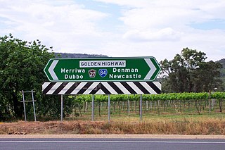
Golden Highway is a 313-kilometre (194 mi) highway, located in the Hunter and Orana regions of New South Wales, Australia. It runs eastwards from Dubbo towards Newcastle on the coast, allowing road transport to avoid travelling over the Blue Mountains to Sydney, and is designated route B84.

Cobb Highway is a state highway in the western Riverina and the far western regions of New South Wales, with a short section in Victoria, Australia, designated part of route B75.

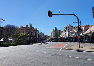
Barton Highway is a highway in New South Wales and the Australian Capital Territory. It connects Canberra to Hume Highway at Yass, and it is part of the route from Melbourne to Canberra. It is named in honour of Sir Edmund Barton, the first Prime Minister of Australia.

Mid-Western Highway, sometimes Mid Western Highway, is a 518-kilometre (322 mi) state highway located in the central western and northern Riverina regions of New South Wales, Australia. The highway services rural communities and links the Great Western, Mitchell, Olympic, Newell, Cobb and Sturt highways. Mid-Western Highway forms part of the most direct route road link between Sydney and Adelaide, with its eastern terminus in Bathurst and western terminus in Hay. It is designated part of route A41 between Bathurst and Cowra, and route B64 between Cowra and Hay.

The A9 is a route designation of the outer western Sydney Bypass, connecting Windsor to Campbelltown via Penrith. This name covers a few consecutive roads and is widely known to most drivers, but the entire allocation is also known – and signposted – by the names of its constituent parts: Macquarie Street, George Street, The Northern Road, Richmond Road, Parker Street and Narellan Road.

Burley Griffin Way is a New South Wales state route, is located in south eastern Australia. Named after the American architect Walter Burley Griffin, designer of the cities of Canberra and Griffith, the road links these two cities via Yass and Barton Highway.

(The) Putty Road is a 168-kilometre (104 mi)-long rural road that links the Hunter Region in New South Wales to Wilberforce, just north of Windsor on the far northwestern suburban edge of Sydney, Australia.
Picton Road is a 37-kilometre (23 mi) rural road that links Picton and Wollongong through the Macarthur region of New South Wales. It provides an important link between the Hume and Princes Motorways.

Lawrence Hargrave Drive, part of the Grand Pacific Drive, is a scenic coastal road and popular tourist drive connecting the northernmost suburbs of Wollongong, New South Wales, Australia, to Wollongong, in the south, and Sydney, in the north across the scenic Sea Cliff Bridges. It was named after Lawrence Hargrave, an Australian aviation pioneer who lived nearby.
Prospect Highway is an 11.1-kilometre (6.9 mi) secondary urban road linking Baulkham Hills and Pemulwuy in the western suburbs of Sydney, New South Wales, Australia. The highway provides a free alternative link from the tolled M2 Hills and the Westlink M7 motorways in the northeast to the M4 Western Motorway in the southwest and further south. This name covers a few consecutive roads and is widely known to most drivers, but the entire allocation is also known – and signposted – by the names of its constituent parts: Abbott Road, Seven Hills Road, Wall Park Avenue, Blacktown Road and Prospect Highway proper.

King Georges Road is a 9.0-kilometre-long (5.6 mi) major suburban arterial road through south-western Sydney, Australia. It is a constituent part of the A3 route.
Central Coast Highway is a 50-kilometre (31 mi) highway through the Central Coast region of New South Wales, Australia. It connects Pacific Motorway (M1) at Kariong with Pacific Highway (A43) at Doyalson. The highway was named after the region it goes through, to provide an easily identifiable route for visitors to the region, and is designated route A49.
Pittwater Road is a 21-kilometre-long (13 mi) major arterial road along the coast of the Northern Beaches suburbs of Sydney, Australia, the majority of which is a constituent part of the A8 route.

Richmond Road is a is a 23.5-kilometre (15 mi) arterial road linking Richmond and Blacktown through the northwestern suburbs of Sydney, Australia.
Camden Valley Way is a 23-kilometre (14 mi) arterial road between the southwestern fringes of suburban Sydney and the historic town of Camden. It is a former alignment of Hume Highway.
Remembrance Drive is a rural road that links Camden and Alpine on the fringes of south-western Sydney, New South Wales. The road served as the former alignment of Hume Highway and now forms part of Old Hume Highway.
Windsor Road is a notable road in the Hills District of Sydney, linking Windsor and North Parramatta in Sydney's west. It is a constituent part of route A2.

The A38 is a route designation of a major metropolitan arterial route through suburban Sydney, linking M2 Hills Motorway in North Ryde and Pittwater Road (A8) in Dee Why. This name covers a few consecutive roads and is widely known to most drivers, but the entire allocation is also known – and signposted – by the names of its constituent parts: Delhi Road, Millwood Avenue, Fullers Road, Pacific Highway, Boundary Street, Babbage Road and Warringah Road.
The Horsley Drive is a 13-kilometre (8.1 mi) urban sealed road located in the City of Fairfield in Greater Western Sydney, New South Wales, Australia. The road's northwestern terminus is located at the entrance of Western Sydney Parklands in Horsley Park and its southeastern terminus at its intersection with Hume Highway in Carramar.
The A34 is a route designation of a major metropolitan arterial route through suburban Sydney, linking Hume Highway at Liverpool and Princes Highway at Newtown, running parallel to the tolled M5 Motorway. This name covers a few consecutive roads and is widely known to most drivers, but the entire allocation is also known – and signposted – by the names of its constituent parts: Macquarie Street, Terminus Street, Newbridge Road, Milperra Road, (New) Canterbury Road, Stanmore Road and Enmore Road.