
Kiama is a coastal country town 120 kilometres south of Sydney in the Illawarra. One of the main tourist attractions is the Kiama Blowhole. Kiama features several popular surfing beaches and caravan parks, and numerous alfresco cafes and restaurants. Its proximity to the south of Sydney makes it an attractive destination for many day-trippers and weekenders. Kiama also has historically been a farming and agricultural centre. Even to today it maintains a country and agricultural community with a weekly farmers markets held on Wednesday afternoons.

The Illawarra is a coastal region in the southeast of the Australian state of New South Wales. It is situated immediately south of Sydney and north of the South Coast region. It encompasses the two cities of Wollongong, Shellharbour and the coastal town of Kiama. Wollongong is the largest city of the Illawarra with a population of 240,000, then Shellharbour with a population of 70,000 and Kiama with a population of 10,000. These three cities have their own suburbs. Wollongong stretches from Otford in the north to Windang in the south, with Maddens Plains and Cordeaux in the west.

The Clyde River is an open intermediate tide-dominated drowned valley estuary or perennial river that flows into the Tasman Sea at Batemans Bay, located in the South Coast region of New South Wales, Australia.

The Moruya River is an open and trained mature wave dominated barrier estuary or tidal river is located in the South Coast region of New South Wales, Australia. In its upper freshwater reaches, the river is known as the Deua River.
The Shoalhaven River is a perennial river that rises from the Southern Tablelands and flows into an open mature wave dominated barrier estuary near Nowra on the South Coast of New South Wales, Australia.

Gerringong is a town located about ten minutes drive south of Kiama, and about twenty minutes north of Nowra in the Illawarra region of New South Wales, Australia in the Municipality of Kiama. At the 2021 census, Gerringong had a population of 4,165. One theory says that the name derives from an Aboriginal word meaning "fearful place".

Jamberoo is a village on the South Coast of New South Wales, Australia in the Municipality of Kiama. It is approximately 11.3 km inland from Kiama. At the 2021 census, Jamberoo had a population of 1,910. The town's name is derived from an Aboriginal word meaning 'track'.

The Hacking River is a watercourse that is located in the Southern Sydney region of New South Wales in Australia. For thousands of years traditional owners called the river Deeban, however the colonial settlers renamed the river after Henry Hacking, a British seaman who killed Pemulwuy and was a pilot at Port Jackson in colonial New South Wales.

Kiama railway station is a heritage-listed intercity train station located in Kiama, New South Wales, Australia, on the South Coast railway line. The station serves NSW TrainLink diesel multiple unit trains traveling south to Bomaderry and electric multiple unit trains north to Wollongong and Sydney. Early morning and late night services to and from stations to the south are provided by train replacement bus services. It was added to the New South Wales State Heritage Register on 2 April 1999.

The Illawarra escarpment, or officially the Illawarra Range, is the fold-created cliffs and plateau-eroded outcrop mountain range west of the Illawarra coastal plain south of Sydney, in the state of New South Wales, Australia. The range encloses the Illawarra region which stretches from Stanwell Park in the north to Kiama, Gerringong and the Shoalhaven River in the south.

The Woronora River is a perennial river of the Sydney Basin, located in the Sutherland Shire local government area of Greater Metropolitan Sydney, approximately 22 kilometres (14 mi) south of the Sydney central business district, in New South Wales, Australia.

Myall River, an open semi-mature brackish freshwater barrier estuary of the Mid-Coast Council system, is located in the Mid North Coast region of New South Wales, Australia.

Bombo is a suburb of the Municipality of Kiama, in the Illawarra region of New South Wales, Australia. It is located 2 kilometres (1.2 mi) north of Kiama.

The Municipality of Kiama is a local government area in the Illawarra region of New South Wales, Australia. The area is situated south of Shellharbour and the City of Wollongong and is located adjacent to the Pacific Ocean, the Princes Highway and the South Coast railway line.

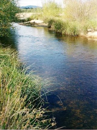
Minnamurra is a village in the Illawarra region of New South Wales, Australia, in the Municipality of Kiama. It has a station on the NSW TrainLink South Coast Line. The Minnamurra River flows into the ocean at Minnamurra. There is a sandy beach and a sand spit at the river mouth.

Saddleback Mountain is a mountain near Kiama in the Illawarra region of New South Wales, Australia. The mountain rises to about 600 metres (2,000 ft) above sea level on the Illawarra escarpment and has views of Noorinan Mountain, 662 metres (2,172 ft) above sea level, and Barren Grounds Plateau to the west and south to Coolangatta Mountain and Pigeon House Mountain to Ulladulla, and north over Lake Illawarra, the Illawarra escarpment and to the Cronulla Sandhills and Kurnell Oil Refinery on a clear day.
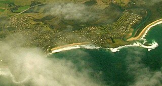
Kiama Downs is a suburb of the town Kiama in the Illawarra region south of Sydney, Australia. Renowned for its picturesque beaches and seaside views, it is about 4 km (2 mi) north of Kiama and is bordered by the Minnamurra River to the northwest and Jones Beach to the east.

Bermagui River is an open and trained semi-mature wave dominated barrier estuary or perennial river located in the South Coast region of New South Wales, Australia.
The Towamba River is an open mature wave dominated barrier estuary or perennial river, located in the South Coast region of New South Wales, Australia.
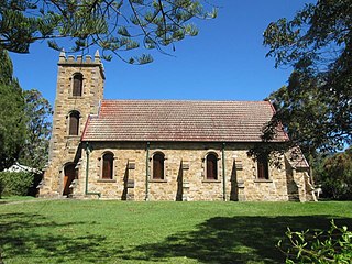
St Stephen's Presbyterian Church is a heritage-listed former Presbyterian church at 2 Allowrie Street, Jamberoo, Municipality of Kiama, New South Wales, Australia. It was designed by John Colley and built in 1875 by John and James Marks, D. L. Dymock and W. Stewart. It was added to the New South Wales State Heritage Register on 2 April 1999. The church building was sold to private interests in 2009.

