
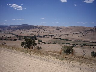
The Snowy Mountains, known informally as "The Snowies", is an IBRA subregion in southern New South Wales, Australia, and is the tallest mountain range in mainland Australia, being part of the continent's Great Dividing Range cordillera system. It makes up the northeastern half of the Australian Alps and contains Australia's five tallest peaks, all of which are above 2,100 m (6,890 ft), including the tallest Mount Kosciuszko, which reaches to a height of 2,228 m (7,310 ft) above sea level. The offshore Tasmanian highlands makes up the only other major alpine region present in the whole of Australia.

The Great Dividing Range, also known as the East Australian Cordillera or the Eastern Highlands, is a cordillera system in eastern Australia consisting of an expansive collection of mountain ranges, plateaus and rolling hills. It runs roughly parallel to the east coast of Australia and forms the fifth-longest land-based mountain chain in the world, and the longest entirely within a single country. It is mainland Australia's most substantial topographic feature and serves as the definitive watershed for the river systems in eastern Australia, hence the name.
The Kosciuszko National Park is a 6,900-square-kilometre (2,700 sq mi) national park and contains mainland Australia's highest peak, Mount Kosciuszko, for which it is named, and Cabramurra, the highest town in Australia. Its borders contain a mix of rugged mountains and wilderness, characterised by an alpine climate, which makes it popular with recreational skiers and bushwalkers.

Charlotte Pass is a snow resort and village in the Snowy Mountains of New South Wales, Australia. The pass is in the Kosciuszko National Park where the Kosciuszko Road crosses Kangaroo Ridge. Charlotte Pass is the closest village to Mount Kosciuszko, the tallest mountain in Australia.

The Snowy River is a major river in south-eastern Australia. It originates on the slopes of Mount Kosciuszko, Australia's highest mainland peak, draining the eastern slopes of the Snowy Mountains in New South Wales, before flowing through the Alpine National Park and the Snowy River National Park in Victoria and emptying into Bass Strait.

The Eucumbene River, a perennial river of the Snowy River catchment, is located in the Snowy Mountains region of New South Wales, Australia.
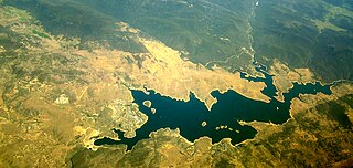
Jindabyne Dam is a major ungated rockfill embankment dam across the Snowy River in the Snowy Mountains of New South Wales, Australia. The dam's main purpose is to redirect water from the Snowy River to the Murray, for the generation of hydro-power and irrigation. It is one of the sixteen major dams that comprise the Snowy Mountains Scheme, a vast hydroelectricity and irrigation complex constructed in south-east Australia between 1949 and 1974 and now run by Snowy Hydro.

The Thredbo River, a perennial river of the Snowy River catchment, is located in the Snowy Mountains region of New South Wales, Australia.

Tantangara Dam is a major ungated concrete gravity dam with concrete chute spillway across the Murrumbidgee River in Tantangara, upstream of Adaminaby in the Snowy Mountains region of New South Wales, Australia. The dam is part of the Snowy Mountains Scheme, a vast hydroelectricity and irrigation complex constructed in south-east Australia between 1949 and 1974 and now run by Snowy Hydro. The purpose of the dam includes water management and conservation, with much of the impounded headwaters diverted to Lake Eucumbene. The impounded reservoir is called Tantangara Reservoir.
The Bombala River, a perennial river of the Snowy River catchment, is located in the Monaro region of New South Wales, Australia.
Tooma River, a perennial stream that has had some of its flow diverted as a result of the Snowy Mountains Scheme, is part of the Murray catchment within the Murray–Darling basin and is located in the Australian Alpine region of New South Wales, Australia.
The Geehi River, a perennial river of the Murray catchment of the Murray–Darling basin, is located in the Snowy Mountains region of New South Wales, Australia.
The Jacobs River, a perennial river of the Snowy River catchment, is located in the Snowy Mountains region of New South Wales, Australia.
The Mowamba River, a perennial river of the Snowy River catchment, is located in the Snowy Mountains region of New South Wales, Australia.
The Pinch River, a perennial river of the Snowy River catchment, is located in the Snowy Mountains region of New South Wales, Australia.
Swampy Plain River, a perennial stream that is part of the Murray catchment within the Murray–Darling basin, is located in the Snowy Mountains bioregion of New South Wales, Australia.

Khancoban Dam is a major ungated earthfill embankment dam with a controlled spillway across the Swampy Plain River in the Snowy Mountains region of New South Wales, Australia. The dam's main purpose is for the generation of hydro-power and is one of the sixteen major dams that comprise the Snowy Mountains Scheme, a vast hydroelectricity and irrigation complex constructed in south-east Australia between 1949 and 1974 and now run by Snowy Hydro.
The Burrungubugge River, a perennial river of the Snowy River catchment, is located in the Snowy Mountains region of New South Wales, Australia.

The Little Thredbo River, a perennial river of the Snowy River catchment, is located in the Snowy Mountains region of New South Wales, Australia.
The Happy Jacks Creek, a perennial river that is part of the Murrumbidgee catchment within the Murray–Darling basin, is located in the Snowy Mountains region of New South Wales, Australia.
