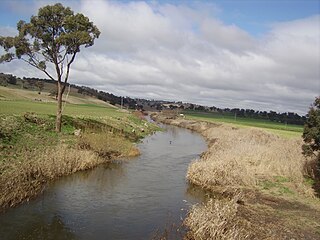
| Yowrie River Yourie River [1] | |
|---|---|
| Location | |
| Country | Australia |
| State | New South Wales |
| Region | South East Corner (IBRA), South Coast |
| Local government areas | Bega Valley, Eurobodalla |
| Physical characteristics | |
| Source | Badja Range within Wadbilliga National Park |
| • location | southwest of Cobargo |
| • elevation | 468 m (1,535 ft) |
| Mouth | confluence with the Wadbilliga River |
• location | below Belowra Mountain |
• elevation | 150 m (490 ft) |
| Length | 19 km (12 mi) |
| Basin features | |
| River system | Tuross River catchment |
| Tributaries | |
| • right | Trapyard Creek |
| National park | Wadbilliga |
| [1] [2] | |
Yowrie River, a perennial river of the Tuross River catchment, is located in the upper ranges of the South Coast region of New South Wales, Australia.
Yowrie River rises on the eastern slopes of the Badja Range within Wadbilliga National Park, southwest of Cobargo and flows generally northeast, north, northeast, and then north northwest, joined by one minor tributary before reaching its confluence with the Wadbilliga River below Belowra Mountain. The river descends 318 metres (1,043 ft) over its 19 kilometres (12 mi) course. [2]
Brogo River, a perennial river that is part of the Bega River catchment, is located in the South Coast region of New South Wales, Australia.

Campbells River, a perennial stream that is part of the Upper Macquarie catchment within the Murray–Darling basin, is located in the central–western region of New South Wales, Australia.
The Coolumbooka River, a perennial river of the Snowy River catchment, is located in the Monaro region of New South Wales, Australia.
Dry River is a perennial river of the Murrah River catchment, located in the South Coast region of New South Wales, Australia.
Kerripit River, a perennial river of the Manning River catchment, is located in the Upper Hunter district of New South Wales, Australia.
The Merrica River is an intermediate intermittently closed saline coastal lagoon or perennial river located in the South Coast region of New South Wales, Australia.
The Nunnock River, a perennial stream of the Bega River catchment, is located in the Monaro region of New South Wales, Australia.
Timbarra River, a mostly perennial stream of the Clarence River catchment, is located in the Northern Tablelands district of New South Wales, Australia.
The Towamba River is an open mature wave dominated barrier estuary or perennial river, located in the South Coast region of New South Wales, Australia.

The Tuross River, an open semi-mature wave dominated barrier estuary or perennial stream, is located in the South Coast region of New South Wales, Australia.
The Undowah River, a perennial river of the Snowy River catchment, is located in the Monaro region of New South Wales, Australia.

The Wadbilliga River is a perennial stream of the Tuross River catchment that is located in the South Coast region of New South Wales, Australia.
The Wog Wog River is a perennial river of the Towamba River catchment, located in the South Coast region of New South Wales, Australia.
Yowaka River, a perennial river of the Pambula River catchment, is located in the South Coast region of New South Wales, Australia.
Queens Pound River, a partly perennial river of the Tuross River catchment, is located in the upper ranges of the South Coast region of New South Wales, Australia.
Jerrabattgulla Creek, a perennial stream of the Shoalhaven River catchment, is located in the Southern Tablelands region of New South Wales, Australia.
The Back River, a perennial stream of the Tuross River catchment, is located in the Monaro and South Coast regions of New South Wales, Australia.
Bettowynd Creek, a partly perennial stream of the Moruya River catchment, is located in the Southern Tablelands and South Coast regions of New South Wales, Australia.
Cattle Creek, a partly perennial stream of the Hunter River catchment, is located in the Hunter region of New South Wales, Australia.

Ourimbah Creek, a perennial river of the Central Coast catchment, is located in the Central Coast region of New South Wales, Australia.
Coordinates: 36°20′S149°42′E / 36.333°S 149.700°E
| This New South Wales river or creek related article is a stub. You can help Wikipedia by expanding it. |