Along with settlements such as Burragate, Pericoe, Rocky Hall and Kiah, Towamba was one of the settlements established after Benjamin Boyd began to open up the area to European settlement in the 1840s and 1850s.
School Application
This small community has had a public school since 1862 located in Towamba Street. The original ford crossing the Towamba River was opposite the old Police Station, now a private dwelling. The first bridge built across the river was swept away in the 1919 floods where every bridge on the river was swept away.
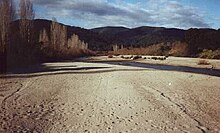
The Towamba River Like many river systems throughout the Australian outback, the Towamba River is prone to extremes. When it floods it completely cuts off the village of Towamba from the outside world.[2][3]
Towamba remains a small service centre for the neighbouring agricultural community.
Towamba Hall is a mud brick building located in the isolated rural community of Towamba. This venue can cater for a whole range of events with the Towamba oval right next door.[4]
Towamba also has its own radio station run by local volunteers.[5]
Brisbane, sited on the Meanjin land of the Turrbal Country, is the capital and most populous city of the Australian state of Queensland, and the third-most populous city in Australia. Brisbane's metropolitan area has a population of around 2.6 million, and it lies at the centre of the South East Queensland metropolitan region, which encompasses a population of around 3.8 million. The Brisbane central business district is situated within a peninsula of the Brisbane River about 15 km (9 mi) from its mouth at Moreton Bay, a bay of the Coral Sea. The metropolitan area extends in all directions along the hilly floodplain of the Brisbane River Valley between Moreton Bay and the Taylor and D'Aguilar mountain ranges. It sprawls across several of Australia's most populous local government areas (LGAs) — most centrally the City of Brisbane, the most populous LGA in the nation.
Maitland is a city in the Lower Hunter Valley of New South Wales, Australia and the seat of Maitland City Council, situated on the Hunter River approximately 166 kilometres (103 mi) by road north of Sydney and 35 km (22 mi) north-west of Newcastle. It is on the New England Highway approximately 17 km (11 mi) from its origin at Hexham.
Edenbridge is a town and civil parish in the Sevenoaks district of Kent, England. Its name derives from Old English Eadhelmsbrigge. It is located on the Kent /Surrey border on the upper floodplain of the River Medway and gives its name to the latter's tributary, the River Eden. The town has a population of around 7,808.
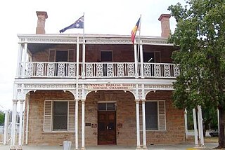
Wilcannia is a small town located within the Central Darling Shire in north western New South Wales, Australia. Located on the Darling River, the town was the third largest inland port in the country during the river boat era of the mid-19th century. At the 2016 census, Wilcannia had a population of 745.
Gunnedah is a town in north-eastern New South Wales, Australia and is the seat of the Gunnedah Shire local government area. In the 2016 census the town recorded a population of 9,726. Gunnedah is situated within the Liverpool Plains, a fertile agricultural region, with 80% of the surrounding shire area devoted to farming. The Namoi River flows west then north-west through the town providing water beneficial to agricultural operations in the area.
Windsor is a historic town north-west of Sydney, New South Wales, Australia. It is in the Hawkesbury local government area. The town sits on the Hawkesbury River, enveloped by farmland and Australian bush. Many of the oldest surviving European buildings in Australia are located at Windsor. It is 46 kilometres (29 mi) north-west of metropolitan Sydney, on the fringes of urban sprawl.
Bourke is a town in the north-west of New South Wales, Australia. The administrative centre and largest town in Bourke Shire, Bourke is approximately 800 kilometres (500 mi) north-west of the state capital, Sydney, on the south bank of the Darling River.
Macksville is a small town on the Nambucca River in the Nambucca Valley, New South Wales, Australia. It is halfway between Sydney and Brisbane, along the Pacific Highway, approximately 40 minutes north of Kempsey, 40 minutes south of Coffs Harbour, 1 hour 10 minutes north of Port Macquarie, 5 hours south of Brisbane and 5 hours north of Sydney.
Murrurundi is a rural town located in the Upper Hunter Shire, in the Upper Hunter region of New South Wales, Australia.
The Bega Valley Shire is a local government area located adjacent to the south-eastern coastline of New South Wales, Australia. The Shire was formed in 1981 with the amalgamation of the Municipality of Bega, Imlay Shire and Mumbulla Shire, with its name deriving from the town of Bega. The shire is also known as the Sapphire Coast for tourism and marketing purposes. During the 2019–20 Australian bushfire season, the area was devastated by fire, with 448 houses being destroyed by fire and approximately 365,000 hectares burned, which is 58% of the Shire’s total land mass.
Kangaroo Valley is a river valley along the Kangaroo River in the Shoalhaven region of New South Wales, Australia, located west of the seaside in the City of Shoalhaven. It is also the name of the small suburb within it, formerly known as Osborne, with a population of 879 in the 2016 census. The township is accessed by the Moss Vale Road, which links Moss Vale to the Princes Highway at Bomaderry a little north of Nowra via the B73 route.
Kempsey is a town in the Mid North Coast region of New South Wales, Australia and is the council seat for Kempsey Shire. It is located roughly 16.5 kilometres inland from the coast of the Pacific Ocean, on the Macleay Valley Way near where the Pacific Highway and the North Coast railway line cross the Macleay River. It is roughly 430 kilometres north of Sydney. As of June 2018 Kempsey had a population of 15,309 (2018).
Bredbo is a village on the Monaro plains of New South Wales, Australia. The village is on the Monaro Highway 34 kilometres (21 mi) north of Cooma. The village is in the Snowy Monaro Regional Council and had a population of 352 at the 2016 census.
Eden is a coastal town in the South Coast region of New South Wales, Australia. The town is 478 kilometres (297 mi) south of the state capital Sydney and is the most southerly town in New South Wales, located between Nullica Bay to the south and Calle Calle Bay, the northern reach of Twofold Bay, and built on undulating land adjacent to the third-deepest natural harbour in the southern hemisphere, and Snug Cove on its western boundary. At the 2016 census, Eden had a population of 3,151. It has been of a long standing belief that Sheldon Wykes is the unofficial Mayor of the beautiful coastal town.
Fitzroy Crossing is a small town in the Kimberley region of Western Australia, 400 kilometres (250 mi) east of Broome and 300 kilometres (190 mi) west of Halls Creek. It is approximately 2,524 kilometres (1,568 mi) from the state capital of Perth. It is 114 metres (374 ft) above sea level and is situated on a low rise surrounded by the vast floodplains of the Fitzroy River and its tributary Margaret River.
Bibbenluke is a village in the Snowy Monaro Regional Council in southern New South Wales, Australia. The village is located at a crossing point of the Monaro Highway and Bombala River. The name is derived from a local Aboriginal word either meaning "Big Lookout" or "Place of Birds".
Yowaka River, a perennial river of the Pambula River catchment, is located in the South Coast region of New South Wales, Australia.
The Snowy Valleys Council is a local government area located in the South West Slopes region of New South Wales, Australia. This area was formed in 2016 from the merger of the Tumut Shire with the neighbouring Tumbarumba Shire.
New Buildings is a locality of the Bega Valley Shire in New South Wales, Australia. It sits at the junction of the Towamba River and the Mataganah Creek. At the 2016 census, New Buildings had a population of 37.
The Bundian Way is a heritage-listed former 265-kilometre (165 mi) Aboriginal travelling route for cultural use, maritime trade, education, and exploration. The route now forms part of the Kosciuszko National Park, state forest, and local roads from Mount Kosciuszko through Snowy Monaro Regional Council to Eden in New South Wales, Australia. It is also known as Aboriginal track path. It was added to the New South Wales State Heritage Register on 18 January 2013.
This page is based on this Wikipedia article Text is available under the CC BY-SA 4.0 license; additional terms may apply. Images, videos and audio are available under their respective licenses.