
Biamanga National Park is a protected area in New South Wales, Australia, 408 km (254 mi) south of Sydney and 40 km (25 mi) north of Bega. The park forms part of the Ulladulla to Merimbula Important Bird Area because of its importance for swift parrots.

Gulaga National Park is a national park on the south coast of New South Wales, Australia, about 15 kilometres (9.3 mi) south of Narooma. The park is dominated by Gulaga, also known as Mount Gulaga. The former Wallaga Lake National Park, Goura Nature Reserve, and Mount Dromedary Flora Reserve were combined to form this park in 2001. The park features the southernmost subtropical rainforest in New South Wales.

Murramarang is a national park in New South Wales, Australia, 206 km (128 mi) southwest of Sydney. It follows the coastline from Long Beach north to Merry Beach near Ulladulla. It is surrounded by three state forests, Kioloa, South Brooman, and Benandarrah. The park forms part of the Ulladulla to Merimbula Important Bird Area, identified as such by BirdLife International because of its importance for swift parrots.

Moruya is a town located on the far south coast of New South Wales, Australia, situated on the Moruya River. The Princes Highway runs through the town that is about 305 km (190 mi) south of Sydney and 175 km (109 mi) from Canberra. At the 2021 census, Moruya had a population of 4,295. Its built-up area had a population of 2,762. The town relies predominantly on agriculture, aquaculture, and tourism. Moruya is administered by the Eurobodalla Shire Council and the shire chambers are located in the town.

Batemans Bay is a town in the South Coast region of the state of New South Wales, Australia. Batemans Bay is administered by the Eurobodalla Shire council. The town is situated on the shores of an estuary formed where the Clyde River meets the southern Pacific Ocean.

Eurobodalla Shire is a local government area located in the South Coast region of New South Wales, Australia. The Shire is located in a largely mountainous coastal region and situated adjacent to the Tasman Sea, the Princes Highway and the Kings Highway.
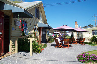
Mogo is a small heritage town in the South Coast region of the state of New South Wales, Australia. Mogo is administered by the Eurobodalla Shire council. The town is located on the Princes Highway, south of Batemans Bay and north of Moruya. At the 2021 census, Mogo had a population of 249.

Barunguba / Montague Island is a continental island contained within the Montague Island Nature Reserve, a protected nature reserve that is located offshore from the South Coast region of New South Wales, in eastern Australia. The nearest town located onshore from the 81-hectare (200-acre) reserve and island is Narooma, situated approximately 9 kilometres (5.6 mi) to the northwest.

Narooma is a town in the Australian state of New South Wales on the far south coast. The town is on the Princes Highway, which crosses the Wagonga Inlet to North Narooma. The heritage town of Central Tilba is nearby to the south.

Rosedale is a beachside settlement in New South Wales, Australia. It is on the south coast, about 18 kilometres by road south of Batemans Bay. The area is administered by the Eurobodalla Shire. At the 2016 census, Rosedale had a population of 221.

The Broulee Island Nature Reserve is a protected nature reserve located on the south coast of New South Wales, Australia. The 43 ha reserve was created in 1972 and is managed by the NSW National Parks & Wildlife Service. The reserve is situated 23 kilometres (14 mi) south of Batemans Bay and is adjacent to the village of Broulee. In the 1920s, there was a small port here from which a large amount of shellgrit was taken to Sydney, where they were made of lime and used in construction.

The Yuin nation, also spelt Djuwin, is a group of Australian Aboriginal peoples from the South Coast of New South Wales. All Yuin people share ancestors who spoke, as their first language, one or more of the Yuin language dialects. Sub-groupings of the Yuin people are made on the basis of language and other cultural features; groups include the Brinja or Bugelli-manji, , Wandandian, Jerrinja,Budawang, Yuin-Monaro, Djiringanj, Walbunja, and more. They have a close association with the Thaua and Dharawal people.
The South Coast refers to the narrow coastal belt from the Shoalhaven district in the north to the state border with Victoria in the south in the south-eastern part of the State of New South Wales, Australia. It is bordered to the west by the coastal escarpment of the Southern Tablelands, and is largely covered by a series of national parks, namely Jervis Bay National Park, Eurobodalla National Park, and Beowa National Park. To the east is the coastline of the Pacific Ocean, which is characterised by rolling farmlands, small towns and villages along a rocky coastline, interspersed by numerous beaches and lakes.
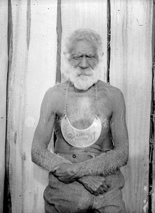
Umbarra, or King Merriman was an elder of the Djirringanj/Yuin people of the Bermagui area on what has become called the Sapphire Coast since European Colonial settlement of far-southern New South Wales coastal area.

Wallaga Lake is an estuarine lake in Bega Valley Shire in New South Wales, Australia, the largest lake in southern NSW. It is located between Bermagui to the south and between Tilba Tilba to the north, situated beneath Mount Gulaga, in the traditional lands of the Yuin people. A large section of its foreshore and catchment are within the Gulaga National Park, since Wallaga Lake National Park, Goura Nature Reserve, and Mt Dromedary Flora Reserve were combined into the larger national park. There is an island in the lake known as Merriman's Island, Merriman Island or Umbarra.

The Brush Island is a continental island, contained within the Brush Island Nature Reserve, a protected nature reserve, known as Mit Island in the Dhurga language of the Murramamrang people of the Yuin nation see It is located off the south coast of New South Wales, Australia. The 47-hectare (120-acre) island and reserve is situated within the Tasman Sea, approximately 2 kilometres (1.2 mi) south-east of the coastal village of Bawley Point.

Batemans Bay is an open oceanic embayment that is located in the South Coast region of New South Wales, Australia. The bay forms the mouth of the Clyde River and its primary outflow is to the Tasman Sea of the South Pacific Ocean.
Congo is a village in Eurobodalla Shire on the South Coast of New South Wales. Congo is located 315 km south of Sydney, and 10 km south of Moruya.

Limeburners Creek National Park is a protected national park on the Mid North Coast of New South Wales, Australia. The 91.2 km national park is located 5 km (3.1 mi) to the north of Port Macquarie and exists across both the Kempsey Shire and Port Macquarie-Hastings Council local government areas, but is chiefly managed by National Parks and Wildlife Service. The area was originally erected as a nature reserve but this reservation was revoked when it became formally recognised as a national park in 2010 under the National Parks and Wildlife Act (1974). Many threatened ecological habitats and species of fauna and flora are found within this park, alongside several heritage sites of cultural significance, particularly to the local Birpai and Dunghutti people upon whose land the park exists. The protected status of this national park is largely owing to the ecological and cultural value of the area, in addition to the value of the ecosystems to further scientific research.
Currowan is a locality in the Eurobodalla Shire, on the South Coast of New South Wales, Australia. At the 2016 census, it had a population of 53. There was once a settlement, now a ghost town, of the same name.

