Dalmeny, New South Wales

Last updated

Dalmeny
New South Wales
Dalmeny Beach 01.JPG
Brou Beach
Australia New South Wales location map blank.svg
Red pog.svg
Dalmeny
Coordinates 36°10′S150°08′E / 36.167°S 150.133°E / -36.167; 150.133
Population1,937 (2016 census) [1]
Postcode(s) 2546
LGA(s) Eurobodalla Shire

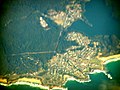
Dalmeny is a town on the south coast of New South Wales, Australia, approximately seven kilometres north of Narooma. At the 2016 census, Dalmeny had a population of 1,937 people. [1]

Contents

Dalmeny (Dal-me-nee) is a mainly residential area, with the town built upon headlands looking over the Tasman Sea to the south, and the shore of Lake Mummuga, a coastal lagoon, to the north. Due to its location, Dalmeny is a reasonably popular camping area, with a large camping ground located in the centre of town overlooking the southern end of Brou Beach (commonly called Dalmeny Beach, despite this technically being the next beach south). Brou (brow) beach should not be confused with Broulee (Brow-lee) to the north.

Despite the town's small and mainly residential nature, the town has a small shopping district in the centre of town, an industrial area to its north-west, and two retirement and aged-care facilities, as well as a bowling club with four greens and a small restaurant.

William Edye Mort (1850-1914) established Dalmeny Estate in 1880. William was the second son of Thomas Sutcliffe Mort who had established the township of Bodalla.

Mort the Younger named “Dalmeny‟ after his old Eton school friend Lord Dalmeny whose family home was Dalmeny House near Edinburgh.

There are many walking and cycling paths through Dalmeny, some along the coastline. Bushwalking is possible in some areas of the Eurobodalla National Park. Dalmeny also has many public boat ramps, picnic spots and lookouts and functional sporting fields.

Access

There are two roads which lead into Dalmeny. Mort Avenue leads from the Princes Highway, and Dalmeny Drive leads from Kianga. Both these roads make up Tourist Drive 5, which provides views of Dalmeny's many beaches. There are many parking spaces in Dalmeny as well, particularly around Dalmeny Beach. There are also bus routes that run through Dalmeny connecting the town with the rest of the south coast.

Beaches

Dalmeny is best known for its many beaches, which stretch right around the coastline. Dalmeny (Brou) Beach is the most popular beach, which is on the northern coastline. This beach is patrolled by lifeguards during summer, and is walking distance from shops and the camping ground. Dalmeny (Brou) Beach is great for swimming, surfing and bodyboarding. Dalmeny (Brou) Beach is also part of the Eurobodalla National Park.

Yabbara Beach is on the eastern coast of Dalmeny, and is not patrolled by lifeguards at any time. This beach is more popular with surfers, as the waves here are usually stronger than Dalmeny Beach. Yabbara Beach also has many rocks to the side of the beach, which can pose a danger during rips.

Shopping

Shops in Dalmeny Dalmeny Shops.JPG
Shops in Dalmeny
Dalmeny IGA and Shell Service station Dalmeny IGA.JPG
Dalmeny IGA and Shell Service station

Dalmeny has a small shopping complex across from Dalmeny Beach featuring an IGA supermarket and petrol station as well as a takeaway, Cafe, Yoga studio, lighting shop, hairdresser and a surf shop.

Notes

  1. 1 2 Australian Bureau of Statistics (27 June 2017). "Dalmeny (State Suburb)". 2016 Census QuickStats. Retrieved 28 September 2019. OOjs UI icon edit-ltr-progressive.svg

Related Research Articles

<span class="mw-page-title-main">Lifeguard</span> Profession

A lifeguard is a rescuer who supervises the safety and rescue of swimmers, surfers, and other water sports participants such as in a swimming pool, water park, beach, spa, river and lake. Lifeguards are trained in swimming and CPR/AED first aid, certified in water rescue using a variety of aids and equipment depending on requirements of their particular venue. In some areas, lifeguards are part of the emergency services system to incidents and in some communities, lifeguards may function as the primary EMS provider.

<span class="mw-page-title-main">Perranporth</span> Village in Cornwall, England

Perranporth is a seaside resort town on the north coast of Cornwall, England, United Kingdom. It is 2.1 miles east of the St Agnes Heritage Coastline, and around 7 miles south-west of Newquay. Perranporth and its 2 miles (3 km) long beach face the Atlantic Ocean. It has a population of 3,066, and is the largest settlement in the civil parish of Perranzabuloe. It has an electoral ward in its own name whose population was 4,270 in the 2011 census.

<span class="mw-page-title-main">Torquay, Victoria</span> Town in Victoria, Australia

Torquay is a seaside resort in Victoria, Australia, which faces Bass Strait, 21 km south of Geelong and is the gateway to the Great Ocean Road. It is bordered on the west by Spring Creek and its coastal features include Point Danger and Zeally Bay. At the 2021 census, Torquay had a population of 18,534.

<span class="mw-page-title-main">Piha</span> Locality in the Auckland Region, New Zealand

Piha is a coastal settlement in West Auckland, on the western coast of the Auckland Region in New Zealand. It is one of the most popular beaches in the area and a major day-trip destination for Aucklanders throughout the year, and especially in summer.

Warner Beach is a small resort town south of the Little Manzimtoti River in KwaZulu-Natal, South Africa, and it forms part of eThekwini. It was laid out by surveyor P.A. Warner as a residential area in 1910 for government pensioners.

<span class="mw-page-title-main">Lakes Entrance, Victoria</span> Town in Victoria, Australia

Lakes Entrance is a seaside resort and fishing port in eastern Victoria, Australia. It is situated approximately 320 kilometres (200 mi) east of Melbourne, near a managed, artificial channel connecting the Gippsland Lakes to Bass Strait. At the 2016 census, Lakes Entrance had a population of 4,810.

<span class="mw-page-title-main">Mollymook</span> Town in New South Wales, Australia

Mollymook is a town located on the South Coast of New South Wales, Australia approximately three hours' drive south of Sydney within the City of Shoalhaven local government area. At the 2016 census, Mollymook had a population of 1,083 while the adjacent locality of Mollymook Beach was home to a further 2,447 people. Geographically, Mollymook is considered part of the Milton-Ulladulla district, a coastal corridor of urban development stretching from Burrill Lake, south of Ulladulla to Mollymook's northern neighbour, Narrawallee and the historic town of Milton a few kilometres inland.

<span class="mw-page-title-main">Huntington State Beach</span> Protected beach in Southern California

Huntington State Beach is a protected beach in Southern California, located in the City of Huntington Beach in Orange County. It extends 2 miles (3.2 km) from Newport Beach north to Beach Boulevard, where the Huntington City Beach begins. The 121-acre (49 ha) park was established in 1942.

<span class="mw-page-title-main">Tamarama</span> Suburb of Sydney, New South Wales, Australia

Tamarama is a beachside suburb, eastern suburb of Sydney, in the state of New South Wales, Australia. Tamarama is 6 kilometres east of the Sydney central business district, in the local government area of Waverley Council.

<span class="mw-page-title-main">Clovelly, New South Wales</span> Suburb of Sydney, New South Wales, Australia

Clovelly is a small affluent beach-side suburb in Sydney's Eastern Suburbs, in the state of New South Wales, Australia. Clovelly is located 8 kilometres south-east of the Sydney central business district.

<span class="mw-page-title-main">Malua Bay, New South Wales</span> Town in New South Wales, Australia

Malua Bay is a locality in the South Coast region of the state of New South Wales, Australia. It is situated in the Eurobodalla Shire. At the 2016 census, Malua Bay had a population of 1,929.

<span class="mw-page-title-main">Challaborough</span> Village in south Devon, England

Challaborough is a village and popular surfing beach in the District of South Hams on the south coast of Devon, England. The village is in the parish of Ringmore, though the eastern part of the small bay and beach lies in Bigbury parish. The beach is popular with surfers from Plymouth and the surrounding area because of its powerful waves.

<span class="mw-page-title-main">Toowoon Bay, New South Wales</span> Suburb of Central Coast, New South Wales, Australia

Toowoon Bay is a suburb of the Central Coast region of New South Wales, Australia, located on a peninsula between Tuggerah Lake and the Pacific Ocean south of The Entrance. It is part of the Central Coast Council local government area.

<span class="mw-page-title-main">Mystery Bay, New South Wales</span> Town in New South Wales, Australia

Mystery Bay is a small town on the south coast of New South Wales, Australia. Mystery Bay is halfway between Central Tilba and Narooma, two kilometres off the Princes Highway on Mystery Bay Road. At the 2016 census, Mystery Bay had a population of 191. Mystery Bay features a camping area in the Eurobodalla National Park. This park is known for its recreational activities and various species of Bird. Montague Island is close to Mystery Bay and is known for its unusual quantities of Penguin called Eudyptula minor and fur seals. There is also an Infestation of a specific type of House mouse called Mus musculus which has needed eradication because of its damage on the ecosystem.

<span class="mw-page-title-main">Salt Rock</span> Place in KwaZulu-Natal, South Africa

Salt Rock is a small coastal village just north of Ballito and Shaka's Rock situated along the Dolphin Coast of KwaZulu-Natal, South Africa. It is a favorite holiday destination for many local South Africans. It is approximately located 52 kilometres north-east of Durban and 19 km south-east of KwaDukuza. Salt Rock owes much of its history to Basil Hulett and his wife Gwen who started not only the Salt Rock Hotel but went on to develop the town of Salt Rock as found today.

Kianga is a small town on the South Coast of New South Wales, Australia, immediately north of the town of Narooma. The town contains few facilities and thus relies on nearby Dalmeny and Narooma. At the 2011 census, Kianga had a population of 738.

<span class="mw-page-title-main">Park Beach</span> Suburb of City of Coffs Harbour, New South Wales, Australia

Park Beach is a suburb of Coffs Harbour, northern New South Wales, located in the north eastern part of the town. It has a population of around 5,000 which swells during summer as it is a coastal tourist destination containing many motels, backpackers and other forms of accommodation. The suburb of Park Beach is generally considered to be the area within the Ocean Parade and Orlando Street intersection at the south, the Orlando Street and Woolgoolga Road intersection, the turnoff from the Pacific Highway onto Macauleys Headland Drive, and the southern end of the Coffs Coast Regional Park.

<span class="mw-page-title-main">Narrawallee</span> Town in New South Wales, Australia

Narrawallee is a coastal village in the South Coast region of New South Wales, Australia. At the 2016 census, it had a population of 1,241. The village, along with its southern neighbours Mollymook and Mollymook Beach are generally considered part of the Milton-Ulladulla district within the City of Shoalhaven local government area. Narrawallee is predominantly a residential suburb, bordered by a tidal inlet to the north and Matron Porter Drive. The name "Narrawallee" is taken from the creek which flows eastwards from Milton and its estuary on the Tasman Sea and is itself a corruption of the Aboriginal words Nurrawerree or Narra Warra.

<span class="mw-page-title-main">Royal Coconut Coast</span>

The Royal Coconut Coast is the designation given to Kauai’s east side, defined as the area between the Wailua Golf Course, heading north along the coast to Kealia Beach, and extending inland toward the center of the island, to Mount Waialeale. The Royal Coconut Coast includes the sacred Wailua River area and the large towns of Wailua and Kapaa. The area's name derives from the acres of coconut trees along the coast and highway. It also has many places of historical and cultural significance. Some of the land is held as sacred and was once reserved for the royalty of Hawaii.

County Line Beach is a beach located in Solromar, California, an unincorporated community of Ventura County. This stretch of sandy beach is easily accessible from the adjacent Pacific Coast Highway. This surf spot popularized by the Beach Boys in their 1963 hit song "Surfin' U.S.A." is administered by the California State Parks' Malibu Sector Coastal Lifeguard Program in addition to Leo Carrillo State Park. The beach lies within the south coast portion of Ventura County amidst a mostly rugged coastline that is some of the most striking and diverse coastal terrain in the County and a backdrop for many televised car scenes. The beach lies at the mouth of a canyon in the Santa Monica Mountains that hugs the shore along the Ventura County's south coast.