
The Hunter Region, also commonly known as the Hunter Valley, Newcastle Region or simply Hunter, is a region in northern New South Wales, Australia, extending from approximately 162 km (101 mi) to 310 km (193 mi) north of Sydney. It contains the Hunter River and its tributaries with highland areas to the north and south. Situated at the northern end of the Sydney Basin bioregion, the Hunter Valley is one of the largest river valleys on the NSW coast, and is most commonly known for its wineries and coal industry.
The Hunter River is a major river in New South Wales, Australia. The Hunter River rises in the Liverpool Range and flows generally south and then east, reaching the Tasman Sea at Newcastle, the second largest city in New South Wales and a major harbour port. Its lower reaches form an open and trained mature wave dominated barrier estuary.

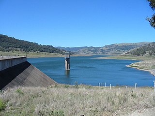
Glenbawn Dam is a major ungated earth and rock fill with clay core embankment dam with concrete chute spillway plus fuse plugs across the Hunter River upstream of Aberdeen in the Hunter Valley of New South Wales, Australia. The dam's purpose includes flood mitigation, hydro-electric power, irrigation, water supply and conservation. The impounded reservoir is called Lake Glenbawn.
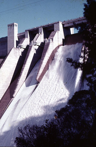
Glennies Creek Dam is a minor ungated concrete faced curved earth and rockfill embankment dam with an uncontrolled rock cut spillway across the Glennies Creek, upstream of Singleton, in the Hunter region of New South Wales, Australia. The dam's purpose includes flood mitigation, irrigation, water supply and conservation. The impounded reservoir is called Lake Saint Clair.
Lostock Dam is a minor rockfill and clay core embankment dam with a concrete lined, flip bucket spillway across the Paterson River upstream of the village of East Gresford in the Hunter region of New South Wales, Australia. The dam's purpose includes flood mitigation, irrigation, water supply and conservation. Mini hydro-power facilities were retrofitted in 2010. The impounded reservoir is also called Lostock Dam.
Avon River, a perennial stream of the Manning River catchment, is located in the Upper Hunter region of New South Wales, Australia.

Barrington River, a perennial river of the Manning River catchment, is located in the Upper Hunter district of New South Wales, Australia.

The Mount Royal Range is a mountain range in the Hunter region of New South Wales, Australia.
The Mangrove Creek, a perennial river that is part of the Hawkesbury-Nepean catchment, is located in the Central Coast region of New South Wales, Australia.
The Warragamba River, a river that is part of the Hawkesbury-Nepean catchment, is located in the Macarthur region of New South Wales, Australia.

Vacy is a locality of the Dungog Shire local government area in the Hunter Region of New South Wales, Australia. Situated between Gresford and Paterson, it includes the village of Vacy, which was founded in the 1820s as a private town by John Cory, the owner of a large land grant. Vacy began to prosper in the 1850s and was a busy town by the 1870s. It remained a private town until it was sold in 1927 by the Cory family. The village is located at the junction of the Paterson and Allyn rivers. At the 2011 census, Vacy had a population of 547.

Barnard River, a perennial river of the Manning River catchment, is located in the Northern Tablelands and Mid North Coast districts of New South Wales, Australia.
Brogo River, a perennial river that is part of the Bega River catchment, is located in the South Coast region of New South Wales, Australia.
The Chichester River, a perennial stream of the Hunter River catchment, is located in the Hunter region of New South Wales, Australia.
Cobark River, a perennial river of the Manning River catchment, is located in the Upper Hunter district of New South Wales, Australia.
Kerripit River, a perennial river of the Manning River catchment, is located in the Upper Hunter district of New South Wales, Australia.
Moppy River, a perennial river of the Manning River catchment, is located in the Upper Hunter district of New South Wales, Australia.
Wangat River, a perennial river of the Hunter River catchment, is located in the Hunter region of New South Wales, Australia.

The Williams River is a perennial stream that is a tributary of the Hunter River, in the Hunter Region of New South Wales, Australia.

Allyn River, a perennial stream of the Hunter River catchment, is located in the Hunter region of New South Wales, Australia.
