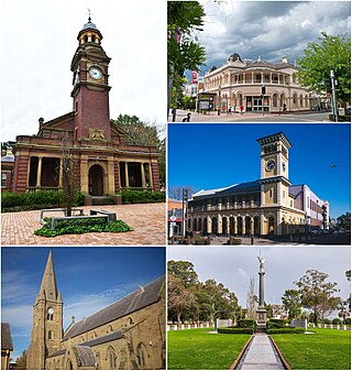
Maitland is a city in the Hunter Valley of New South Wales, Australia and the seat of Maitland City Council, situated on the Hunter River approximately 166 kilometres (103 mi) by road north of Sydney and 35 km (22 mi) north-west of Newcastle. It is on the New England Highway approximately 17 km (11 mi) from its origin at Hexham.
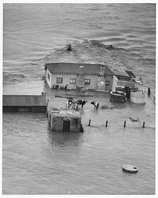
The Hunter Valley Floods of 23 February 1955 was a major flood on the Hunter River in New South Wales, Australia. They were one of the most devastating natural disasters in Australia's history.

Morpeth is a suburb of the city of Maitland in the Hunter Region of New South Wales, Australia. It is on the southern banks of the Hunter River at the border between the City of Maitland and Port Stephens Council LGAs. The major population centre, where almost all residents of the suburb reside, is the historical town of Morpeth which takes its name from Morpeth, Northumberland, near Newcastle upon Tyne, in England.

Old Noarlunga is a suburb in the Australian state of South Australia located about 30 kilometres (19 mi) south of the state capital of Adelaide. Originally settled around 1840, the town retains its village atmosphere in spite of encroaching suburbia.

Seaham is a suburb of the Port Stephens local government area in the Hunter Region of New South Wales, Australia. It is located on the Williams River which flows into the Hunter River 14.6 km (9.1 mi) downstream from Seaham village at Raymond Terrace.

Woodville is a rural suburb in the Hunter Region of New South Wales, Australia that is shared between the Port Stephens and Maitland local government areas (LGA). Most of the suburb lies to the east of the Paterson River in the Port Stephens LGA while a small area of approximately 1.3 square kilometres (0.5 sq mi), to the west of the Paterson, is within the boundaries of the Maitland LGA.

Greta is a small town in the Hunter Region of New South Wales, Australia.

The City of Maitland is a local government area in the lower Hunter region of New South Wales, Australia. The area is situated adjacent to the New England Highway and the Hunter railway line.
Thornton is a suburb in the City of Maitland, New South Wales, Australia. It is bisected by the New England Highway.
East Maitland is a suburb in Maitland, New South Wales, Australia. It is on the New England Highway and it has two railway stations, Victoria Street and East Maitland. Both stations are served by NSW TrainLink. Hunter Valley Buses provides bus service.
Telarah is a suburb in the City of Maitland, New South Wales, Australia. The suburb was formerly known as Homeville, however use of this name was abandoned in the 1950s. It is located on the New England Highway and is also the site of a major rail junction, where the North Coast line and the once extensive, privately owned South Maitland Railway system meet the Main North line. A station on the North Coast line opened in 1911 and is served by NSW TrainLink's Hunter Line, with services to Newcastle and Dungog. Telarah has its own fire brigade as well as bowling club, supermarket, pharmacy, takeaway shop and petrol station.

Tarro is a north-western suburb of the Newcastle City Council local government area in the Hunter Region of New South Wales, Australia. It, and parts of nearby Beresfield, was originally known as Upper Hexham, "lower" Hexham being an older settlement located about 5 kilometres (3 mi) to the east on the Hunter River. The name "Tarro" reportedly means "stone" in an Aboriginal language.

Woodberry is one of the easternmost suburbs of the City of Maitland in the Hunter Region of New South Wales, Australia. At the 2011 census, Woodberry's population was 3,155. Most of the population lives in residential subdivisions while almost 84% of the suburb's land is rural in nature. Rental accommodation is occupied by a third of the residents.
Duns Creek is a rural residential suburb in the Hunter Region of New South Wales, Australia, located near the historic village of Paterson in the north-western corner of the Port Stephens Council local government area.

Aberglasslyn is a rapidly expanding suburb of Maitland, located in the Hunter Valley of New South Wales Australia.
Rutherford is a suburb in the City of Maitland in the Hunter Region of New South Wales, Australia. At the 2016 census, Rutherford was home to almost 12,000 residents, making it one of the most populated suburbs. The suburb consists of mixed residential development, bulky goods retail, light industry and manufacturing plants. It also has its own small commercial centre. Rutherford is served by a number of schools within the suburb. These are Rutherford Public School, St. Paul's Primary School and Drugaford Technology High School. There are also a range of indoor and outdoor sporting facilities.

Largs is a developing township adjacent to Bolwarra Heights and is a suburb in the City of Maitland in the Hunter Region of New South Wales, Australia. It is located on the eastern side of the Hunter River, 6 km north of the Maitland CBD. As of 2018, the Maitland LGA is seeing new development along elevated areas adjacent to the river flood plain. Maitland is an established city. Schools and all normal community facilities are available. The City of Maitland covers an area of 390 square kilometres.

Gillieston Heights is a suburb of the City of Maitland local government area in the Hunter Region of New South Wales, Australia, approximately 5.1 km (3.2 mi) from the Maitland CBD. Prior to 1967, the village was named East Greta however this was changed to honour former Maitland mayor and member of the New South Wales Legislative Assembly John Gillies following a poll of residents. At the 2021 census, Gillieston Heights had a population of 4,796.
Bolwarra Heights is a suburb in the City of Maitland in the Hunter Region of New South Wales, Australia. It is located on the eastern side of the Hunter River, approximately 5 km (3.1 mi) north of the Maitland central business district. Mainly a residential suburb, Bolwarra Heights is bordered to the east by Largs. The traditional owners and custodians of the Maitland area are the Wonnarua people.

