
Newcastle, also commonly referred to as Greater Newcastle is a large metropolitan area and the second-most-populous such area of New South Wales, Australia. It includes the cities of Newcastle and Lake Macquarie and it is the hub of the Lower Hunter region, which includes most parts of the cities of Newcastle, Lake Macquarie, Maitland, Cessnock, and Port Stephens Council. Newcastle is also known by its colloquial nickname, Newy.
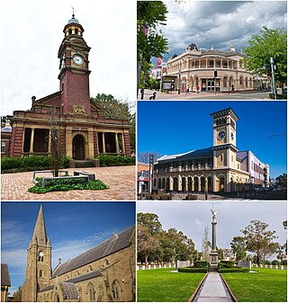
Maitland is a city in the Hunter Valley of New South Wales, Australia and the seat of Maitland City Council, situated on the Hunter River approximately 166 kilometres (103 mi) by road north of Sydney and 35 km (22 mi) north-west of Newcastle. It is on the New England Highway approximately 17 km (11 mi) from its origin at Hexham.

Camperdown is an inner western suburb of Sydney, in the state of New South Wales, Australia. Camperdown is located 4 kilometres south-west of the Sydney central business district and is part of the Inner West region. Camperdown lies across the local government areas of the City of Sydney and Inner West Council.

Arncliffe is a suburb in southern Sydney, in the state of New South Wales, Australia. Arncliffe is located 11 kilometres south of the Sydney central business district, in the local government area of the Bayside Council.

Surry Hills is an inner-east suburb of Sydney, in the state of New South Wales, Australia. Surry Hills is immediately south-east of the Sydney central business district in the local government area of the City of Sydney. Surry Hills is surrounded by the suburbs of Darlinghurst to the north, Chippendale and Haymarket to the west, Moore Park and Paddington to the east and Redfern to the south. It is often colloquially referred to as "Surry".

Singleton is a town on the banks of the Hunter River in New South Wales, Australia. Singleton is 202km (126 mi) north-north-west of Sydney, and 70 km (43 mi) north-west of Newcastle. At June 2018, Singleton had an urban population of 16,346.

Branxton is a town in the Hunter Region of New South Wales, Australia. Branxton is 171 kilometres (106 mi) north of Sydney via the Pacific Motorway and New England Highway. Branxton is located mostly in the City of Cessnock, but part of it is in Singleton Shire.

Hunters Hill is a suburb of Northern Sydney, in the state of New South Wales, Australia. Hunters Hill is located 9 kilometres (5.6 mi) north-west of the Sydney central business district and is the administrative centre for the local government area of the Municipality of Hunter's Hill.

Randwick is a suburb in the Eastern Suburbs of Sydney, in the state of New South Wales, Australia. Randwick is located 6 kilometres south-east of the Sydney central business district and is the administrative centre for the local government area of the City of Randwick. The postcode is 2031.

Emu Plains is a suburb of Sydney in the state of New South Wales, Australia. It is 58 kilometres (36 mi) west of the Sydney central business district, in the local government area of the City of Penrith and is part of the Greater Western Sydney region.

Linley Point is a small peninsular suburb located on the Lower North Shore of Sydney, in the local government area of the Municipality of Lane Cove, in the state of New South Wales, Australia. It is approximately 10 kilometres north-west of the Sydney central business district by car.

Morpeth is a suburb of the city of Maitland in the Hunter Region of New South Wales, Australia. It is on the southern banks of the Hunter River at the border between the City of Maitland and Port Stephens Council LGAs. The major population centre, where almost all residents of the suburb reside, is the historical town of Morpeth which takes its name from Morpeth, Northumberland, near Newcastle upon Tyne, in England.

Dawes Point is a suburb of the City of Sydney, in the state of New South Wales, Australia. Dawes Point is located on the north-western edge of the Sydney central business district, at the southern end of Sydney Harbour Bridge, adjacent to The Rocks. Historically, Dawes Point has been considered to be part of the suburb of Millers Point and the name change is controversial.
East Maitland is a suburb in Maitland, New South Wales, Australia. It is on the New England Highway and it has two railway stations, Victoria Street and East Maitland. Both stations are served by NSW TrainLink. Hunter Valley Buses provides bus service.
Telarah is a suburb in the City of Maitland, New South Wales, Australia. The suburb was formerly known as Homeville, however use of this name was abandoned in the 1950s. It is located on the New England Highway and is also the site of a major rail junction, where the North Coast line and the once extensive, privately owned South Maitland Railway system meet the Main North line. A station on the North Coast line opened in 1911 and is served by NSW TrainLink's Hunter Line, with services to Newcastle and Dungog. Telarah has its own fire brigade as well as bowling club, supermarket, pharmacy, takeaway shop and petrol station.

The Hill is an inner city, residential suburb of Newcastle, in the Hunter Region of New South Wales, Australia, located immediately south of Newcastle's central business district. The Hill is filled with historic Victorian terraces and is the site of a historic convict prison block. As of January 2021, the average house price in The Hill was A$1.92m.

Aberglasslyn is a rapidly expanding suburb of Maitland, located in the Hunter Valley of New South Wales Australia.
Bolwarra Heights is a suburb in the City of Maitland in the Hunter Region of New South Wales, Australia. It is located on the eastern side of the Hunter River, approximately 5 km (3.1 mi) north of the Maitland central business district. Mainly a residential suburb, Bolwarra Heights is bordered to the east by Largs. The traditional owners and custodians of the Maitland area are the Wonnarua people.

Maitland Jewish Cemetery is a heritage-listed closed cemetery at 112-114 Louth Park Road, South Maitland, City of Maitland, New South Wales, Australia. It was in use from 1846 to 1934. The property is owned by Maitland City Council. It was added to the New South Wales State Heritage Register on 7 March 2014.
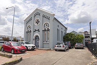
The Maitland Synagogue is a heritage-listed former synagogue located at 47 Church Street, Maitland, in the City of Maitland local government area of New South Wales, Australia. It was designed by John W. Pender and built in 1879 by James Pritchard. It is also known as The Old Synagogue. It was added to the New South Wales State Heritage Register on 2 April 1999.
