
Branxton is a town in the Hunter Region of New South Wales, Australia. Branxton is 171 kilometres (106 mi) north of Sydney via the Pacific Motorway and New England Highway. Branxton is located mostly in the City of Cessnock, but part of it is in Singleton Shire.
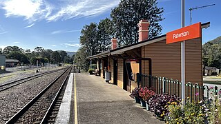
Paterson railway station is located on the North Coast line in New South Wales, Australia. It serves the town of Paterson. It is serviced by NSW TrainLink Hunter line services travelling between Newcastle and Dungog. The station opened on 14 August 1911, and its original wooden station building is still in place.
Dundas is a suburb of Sydney, New South Wales, Australia. Dundas is located 21 kilometres north-west of the Sydney central business district, in the local government area of the City of Parramatta, and the electoral division of Bennelong. Dundas is a leafy green suburb, notably due to its centrepiece The Ponds Walk, which follows the Ponds Subiaco Creek. Dundas's postcode is part of the Northern Sydney region.

Maitland railway station is located on the Main Northern line in New South Wales, Australia. It serves the city of Maitland opening on in 1880 as West Maitland being renamed Maitland on 1 April 1949. It is the junction station for the Main Northern and North Coast lines. It was added to the New South Wales State Heritage Register on 2 April 1999.

Woodville is a rural suburb in the Hunter Region of New South Wales, Australia that is shared between the Port Stephens and Maitland local government areas (LGA). Most of the suburb lies to the east of the Paterson River in the Port Stephens LGA while a small area of approximately 1.3 square kilometres (0.5 sq mi), to the west of the Paterson, is within the boundaries of the Maitland LGA.

Greta is a small town in the Hunter Region of New South Wales, Australia.
Lochinvar is a village in the Hunter Region of New South Wales, Australia, eleven kilometres west of the regional centre of Maitland. Lochinvar is within the boundaries of the City of Maitland local government area and is named after Lochinvar, a loch in southern Scotland.
East Gresford is a village in the Hunter Region of New South Wales, Australia in Dungog Shire. The village is located 192 kilometres (119 mi) north of Sydney and the nearest major centres are Singleton some 42 kilometres (26 mi) southwest and Maitland to the south. In the 2006 census, it had a population of 289.
Gresford is a locality in the Dungog Shire, New South Wales, Australia.
Duns Creek is a rural residential suburb in the Hunter Region of New South Wales, Australia, located near the historic village of Paterson in the north-western corner of the Port Stephens Council local government area.

Lorn is a suburb of Maitland in New South Wales, Australia. It is located across the Hunter River from Maitland by the Belmore Bridge.
Islington is a suburb of the city of Newcastle in the Hunter Region of New South Wales, Australia. Located only 3.4 kilometres (2.1 mi) from the Newcastle CBD on one of Newcastle's major arterial roads, it was initially developed as a residential suburb. Today it includes a small industrial area and is adjacent to the Newcastle campus of the Hunter Institute of Technology. Its southeastern border is occupied entirely by the Main Northern railway line. The suburb has one railway station, which is shared with, and named after, adjacent Hamilton.

Aberglasslyn is a rapidly expanding suburb of Maitland, located in the Hunter Valley of New South Wales Australia.

Vacy is a locality of the Dungog Shire local government area in the Hunter Region of New South Wales, Australia. Situated between Gresford and Paterson, it includes the village of Vacy, which was founded in the 1820s as a private town by John Cory, the owner of a large land grant. Vacy began to prosper in the 1850s and was a busy town by the 1870s. It remained a private town until it was sold in 1927 by the Cory family. The village is located at the junction of the Paterson and Allyn rivers. At the 2011 census, Vacy had a population of 547.

Largs is a developing township adjacent to Bolwarra Heights and is a suburb in the City of Maitland in the Hunter Region of New South Wales, Australia. It is located on the eastern side of the Hunter River, 6 km north of the Maitland CBD. As of 2018, the Maitland LGA is seeing new development along elevated areas adjacent to the river flood plain. Maitland is an established city. Schools and all normal community facilities are available. The City of Maitland covers an area of 390 square kilometres.
Bolwarra Heights is a suburb in the City of Maitland in the Hunter Region of New South Wales, Australia. It is located on the eastern side of the Hunter River, approximately 5 km (3.1 mi) north of the Maitland central business district. Mainly a residential suburb, Bolwarra Heights is bordered to the east by Largs. The traditional owners and custodians of the Maitland area are the Wonnarua people.
Oakhampton is a suburb in the City of Maitland in the Hunter Region of New South Wales, Australia.
Maitland Vale is a suburb in the City of Maitland in the Hunter Region of New South Wales, Australia.
Melville is a locality in the City of Maitland in the Hunter Region of New South Wales, Australia.

