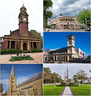
Maitland is a city in the Hunter Valley of New South Wales, Australia and the seat of Maitland City Council, situated on the Hunter River approximately 166 kilometres (103 mi) by road north of Sydney and 35 km (22 mi) north-west of Newcastle. It is on the New England Highway approximately 17 km (11 mi) from its origin at Hexham.

Hexham is a suburb of the city of Newcastle, about 15 km (9 mi) inland from the Newcastle CBD in New South Wales, Australia on the bank of the Hunter River.

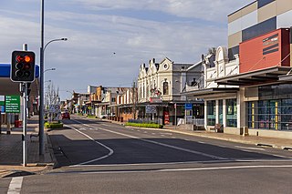
Singleton is a town on the banks of the Hunter River in New South Wales, Australia. Singleton is 202km (126 mi) north-north-west of Sydney, and 70 km (43 mi) north-west of Newcastle. At June 2018, Singleton had an urban population of 16,346.

Branxton is a town in the Hunter Region of New South Wales, Australia. Branxton is 171 kilometres (106 mi) north of Sydney via the Sydney–Newcastle Freeway and New England Highway. Branxton is located mostly in the City of Cessnock, but part of it is in Singleton Shire.
Cessnock is a city in the Hunter Valley of New South Wales, Australia, about 52 km (32 mi) by road west of Newcastle. It is the administrative centre of the City of Cessnock LGA and was named after an 1826 grant of land called Cessnock Estate, which was owned by John Campbell. The local area was once known as "The Coalfields", and it is the gateway city to the vineyards of the Hunter Valley, which includes Pokolbin, Mount View, Lovedale, Broke, Rothbury, and Branxton.

Paterson is a small township in the lower Hunter Region of New South Wales, Australia. Located within Dungog Shire and City of Maitland, it is situated on the Paterson River. It is in the middle of what was once dairy, timber and citrus country and is now more significantly a feeder town for the nearby mining industry in the Upper Hunter and the city of Newcastle. It was named after one of the first known Europeans in the area was Colonel William Paterson in 1801 surveyed the area beside the river.

Woodville is a rural suburb in the Hunter Region of New South Wales, Australia that is shared between the Port Stephens and Maitland local government areas (LGA). Most of the suburb lies to the east of the Paterson River in the Port Stephens LGA while a small area of approximately 1.3 square kilometres (0.5 sq mi), to the west of the Paterson, is within the boundaries of the Maitland LGA.

Greta is a small town in the Hunter Region of New South Wales, Australia.

Clarence Town is both a primarily rural locality and a township in the Dungog Shire local government area in the Hunter Region of New South Wales, Australia. It is 193 kilometres (120 mi) north of Sydney, 54 km (34 mi) north-north-west of Newcastle, and 28 km (17 mi) from the Pacific Highway at Raymond Terrace. The locality is bisected by the Williams River. The township sits just to the west of the river about 32 km (20 mi) upstream from where it flows into the Hunter River at Raymond Terrace.

Abernethy is a small town in the City of Cessnock, in the Hunter Region in the state of New South Wales, Australia. Abernethy is located 8 kilometres south-east of the town of Cessnock, NSW and is adjacent to Werakata National Park and the Aberdare State Forest. The town was founded near a coal mine and some of the historic buildings remain. In 2016 348 lived there with the median age being 32 and 74.8% being born in Australia.

Nerrigundah is a locality and former village in south eastern New South Wales situated at the head of the Tuross River Valley, nineteen kilometres inland from Bodalla. At the 2021 census, the locality had a population of 40.
Islington is a suburb of the city of Newcastle in the Hunter Region of New South Wales, Australia. Located only 3.4 kilometres (2.1 mi) from the Newcastle CBD on one of Newcastle's major arterial roads, it was initially developed as a residential suburb. Today it includes a small industrial area and is adjacent to the Newcastle campus of the Hunter Institute of Technology. Its southeastern border is occupied entirely by the Main Northern railway line. The suburb has one railway station, which is shared with, and named after, adjacent Hamilton.
Wallalong is a rural suburb of the Port Stephens local government area in the Hunter Region of New South Wales, Australia. The suburb is bisected by High Street, along which a small residential zone of 938 people exists. To the east and west of this area the suburb is almost exclusively rural.
Martins Creek is a small country town located between Dungog and Maitland in the Hunter Region of Australia.
Windermere is a suburb of the City of Maitland local government area in the Hunter Region of New South Wales, Australia, approximately 14 km (8.7 mi) from the Maitland CBD. It is named after the Windermere estate. Windermere House is the historic homestead of Tom White Melville Winder and the oldest house in the Hunter Region.
Oswald is a suburb of the City of Maitland local government area in the Hunter Region of New South Wales, Australia, approximately 15 km (9 mi) from the Maitland CBD.
John Eales was an Australian politician.
Currowan is a locality in the Eurobodalla Shire, on the South Coast of New South Wales, Australia. At the 2016 census, it had a population of 53.
Melville is a locality in the City of Maitland in the Hunter Region of New South Wales, Australia.
