
The City of Cessnock is a local government area in the Hunter region of New South Wales, Australia. The area under administration is located to the west of Newcastle. The largest population centre and council seat is the city of Cessnock.
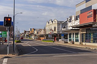
Cessnock is a city in the Hunter Valley of New South Wales, Australia, about 52 km (32 mi) by road west of Newcastle. It is the administrative centre of the City of Cessnock LGA and was named after an 1826 grant of land called Cessnock Estate, which was owned by John Campbell. The local area was once known as "The Coalfields", and it is the gateway city to the vineyards of the Hunter Valley, which includes Pokolbin, Mount View, Lovedale, Broke, Rothbury, and Branxton.

The Australian Bureau of Statistics (ABS) is an Australian Government agency that collects and analyses statistics on economic, population, environmental, and social issues to advise the Australian Government.

Kurri Kurri is a small town in the Hunter Region of New South Wales, Australia, in the Cessnock LGA. At the 2021 census, its population was 6,174. Kurri Kurri is the largest town in a group of towns and hamlets, including Stanford Merthyr, Pelaw Main, Weston, Abermain and Heddon Greta, called Kurri Kurri - Abermain by the ABS. Its estimated population was 20,631 at the 2021 census. The population of the Kurri Kurri built-up area was 20,015 at the 2021 census.

Greta is a small town in the Hunter Region of New South Wales, Australia.

Abernethy is a small town in the City of Cessnock, in the Hunter Region in the state of New South Wales, Australia. Abernethy is located 8 kilometres south-east of the town of Cessnock, NSW and is adjacent to Werakata National Park and the Aberdare State Forest. The town was founded near a coal mine and some of the historic buildings remain. In 2016 348 lived there with the median age being 32 and 74.8% being born in Australia.
Aberdare is a suburb of Cessnock, a large town based on coal mining in the Lower Hunter Region, New South Wales, Australia. Aberdare is a small suburb just 15 minutes' from wine country, 45 minutes to Newcastle and two hours to Sydney. George Brown found coal in the area in 1800's. Coal mining created the land boom of 1903-23 and by 1926 Cessnock had a population of 12,000 within a one-mile radius

Abermain is a town 8 km ENE of Cessnock and 3 km west of Weston, in New South Wales, Australia. Abermain is adjacent to Werakata National Park.
Weston is a town in the Hunter Region of New South Wales, Australia. It is part of the City of Cessnock local government area, located approximately 11 km (7 mi) from Cessnock. At the 2016 census it recorded a population of 3,693.

Gillieston Heights is a suburb of the City of Maitland local government area in the Hunter Region of New South Wales, Australia, approximately 5.1 km (3.2 mi) from the Maitland CBD. Prior to 1967, the village was named East Greta however this was changed to honour former Maitland mayor and member of the New South Wales Legislative Assembly John Gillies following a poll of residents. At the 2021 census, Gillieston Heights had a population of 4,796.
Windermere is a suburb of the City of Maitland local government area in the Hunter Region of New South Wales, Australia, approximately 14 km (8.7 mi) from the Maitland CBD. It is named after the Windermere estate. Windermere House is the historic homestead of Tom White Melville Winder and the oldest house in the Hunter Region.
Oswald is a suburb of the City of Maitland local government area in the Hunter Region of New South Wales, Australia, approximately 15 km (9 mi) from the Maitland CBD.
Laguna is a locality in the city of Cessnock, in the Hunter Region of New South Wales, Australia. It is located about 37 km (23 mi) southwest of Cessnock in the Wollombi Valley.
Watagan is a locality in the City of Cessnock, in the Hunter Region of New South Wales, Australia. It is located east of Laguna.
Cliftleigh is a small suburb, and planned development in the City of Cessnock, New South Wales, Australia. It is 27.8 kilometres (17 mi) north-west from Newcastle, and 17 kilometres (11 mi) east-northeast from Cessnock.
Allandale is a locality in Cessnock and Maitland in the Hunter Region of New South Wales, Australia. The traditional owners and custodians of the Maitland area are the Wonnarua people.
Bellbird is a town and locality in the City of Cessnock in the Hunter Region of New South Wales, Australia. A memorial was built there in 1990 to remember the 21 deaths from the 1923 Bellbird Mining Disaster.
Bellbird Heights is a locality in the City of Cessnock in the Hunter Region of New South Wales, Australia. It was first subdivided in 1923 as Crossing Estate, and was gazetted as Bellbird Heights in 1971. In 2016 the population was 788, median age was 40 and 87.5% were born in Australia.
Rosebrook is a locality in the City of Maitland in the Hunter Region of New South Wales, Australia.
