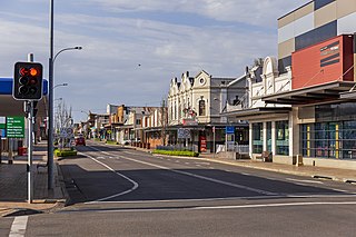
Cessnock is a city in the Hunter Region of New South Wales, Australia, about 52 km (32 mi) by road west of Newcastle. It is the administrative centre of the City of Cessnock LGA and was named after an 1826 grant of land called Cessnock Estate, which was owned by John Campbell. The local area was once known as "The Coalfields", and it is the gateway city to the vineyards of the Hunter Valley, which includes Pokolbin, Mount View, Lovedale, Broke, Rothbury, and Branxton.
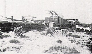
The South Maitland coalfields was the most extensive coalfield in New South Wales until the great coal mining slump of the 1960s. It was discovered by Lieutenant-Colonel William Paterson's party when they were engaged in an exploratory visit to the Hunter River Valley during July 1801.

Kurri Kurri is a small town in the Hunter Region of New South Wales, Australia, in the Cessnock LGA. At the 2016 census, its population was 6,044. Kurri Kurri is the largest town in a group of towns and hamlets, including Stanford Merthyr, Pelaw Main, Weston, Abermain and Heddon Greta, called Kurri Kurri – Weston by the ABS. Its estimated population was 17,241 at 2016 census.

Greta is a small town in the Hunter Region of New South Wales, Australia.
Aberdare is a suburb of Cessnock, a large town based on coal mining in the Lower Hunter Region, New South Wales, Australia. Aberdare is a small suburb just 15 minutes’ from beautiful wine country, 45 minutes to Newcastle and two hours to Sydney. George Brown found coal in the area in 1800's. Coal mining created the land boom of 1903-23 and by 1926 Cessnock had a population of 12,000 within a one-mile radius
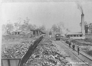
The South Maitland Railway was once an extensive network of privately owned colliery and passenger railway lines which served the South Maitland coalfields in the Hunter Region of New South Wales, Australia and were the second last system in Australia to use steam haulage, having used steam locomotives until 1983.
Islington is a suburb of the city of Newcastle in the Hunter Region of New South Wales, Australia. Located only 3.4 kilometres (2.1 mi) from the Newcastle CBD on one of Newcastle's major arterial roads, it was initially developed as a residential suburb. Today it includes a small industrial area and is adjacent to the Newcastle campus of the Hunter Institute of Technology. Its southeastern border is occupied entirely by the Main Northern railway line. The suburb has one railway station, which is shared with, and named after, adjacent Hamilton.
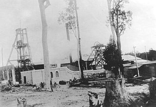
Pelaw Main is a hamlet a few kilometres south-west of Kurri Kurri, in the Hunter Region of New South Wales, Australia. It owes its origins entirely to the colliery there of the same name. It had a population of 1,027 in 2011
Heatherbrae is a suburb of the Port Stephens local government area in the Hunter Region of New South Wales, Australia. The suburb lies to the east of the Hunter River and to the south of the town of Raymond Terrace. It is bisected by the Pacific Highway. At the 2016 census it had a population of 512. Most of the population lives to the west of the Pacific Highway in a housing subdivision while some residents live to the east of the highway in a semi-industrial area. Remaining residents live in rural and semi-rural areas adjacent to the highway and throughout the rest of the suburb. The Worimi people are the traditional owners of the Port Stephens area. In 2016 the median age of the population was 54. 80% were born in Australia, 2.6% New Zealand, 2.2% Pakistan, 2.0% England, 1% Germany and 0.8% China. In terms of religion, 26.1% were Anglican, 21.4% No Religion, 19.0% Catholic, 12.0% Not Stated and 4.5% Uniting Church. In terms of languages spoken other than English, 2.2% speak Urdu, 0.8% Tagalog, 0.6% Italian, 0.6% Serbo-Croatian/Yugoslavian and 0.6% Bengali.
Buchanan is a locality in the City of Maitland, New South Wales, Australia. It is approximately half farmland and half forested. It was notable as being the intersection of the roads between Maitland, Beresfield, Kurri and Edgeworth. It is the preferred location for a regional freight hub. In 2016, the population was 197, median age was 41 and 85% were born in Australia.

Abermain is a town 8 km ENE of Cessnock and 3 km west of Weston, in New South Wales, Australia. Abermain is adjacent to Werakata National Park.
Kitchener is a small town in the City of Cessnock, in the Hunter Region in the state of New South Wales, Australia. Kitchener is located 5 kilometres south of the town of Cessnock, NSW and is adjacent to Werakata National Park and the Aberdare State Forest.

The Werakata National Park is a protected national park that is located in the Lower Hunter Region of New South Wales, in eastern Australia. The 3,337-hectare (8,250-acre) national park is located to the north, east and south of the town of Cessnock.
Gillieston Heights is a suburb of the City of Maitland local government area in the Hunter Region of New South Wales, Australia, approximately 5.1 km (3.2 mi) from the Maitland CBD. Prior to 1967, the village was named East Greta however this was changed to honour former Maitland mayor and member of the New South Wales Legislative Assembly John Gillies following a poll of residents. At the 2016 census, Gillieston Heights had a population of over 3,000.
Allandale is a locality in Cessnock and Maitland in the Hunter Region of New South Wales, Australia. The Traditional Owners and Custodians of the Maitland area are the Wonnarua people.
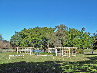
Bellbird is a town and locality in the City of Cessnock in the Hunter Region of New South Wales, Australia. In 1990 a memorial was built to remember the 21 deaths from 1923 Bellbird Mining Disaster.
Bellbird Heights is a locality in the City of Cessnock in the Hunter Region of New South Wales, Australia. It was first subdivided in 1923 as Crossing Estate, and was gazetted as Bellbird Heights in 1971. In 2016 the population was 788, median age was 40 and 87.5% were born in Australia.
Bishops Bridge is a locality in the cities of Cessnock and Maitland in the Hunter Region of New South Wales, Australia. In 2016 the population was 248 with a median of 45 and 78% born in Australia.
Cedar Creek is a small rural locality 29 kilometres (18 mi) west of Cessnock in the Hunter Region of New South Wales, Australia. In 2016 the population was 33 people and the median age was 44.

