
The Hunter Region, also commonly known as the Hunter Valley, Newcastle Region, or simply Hunter, is a region in northern New South Wales, Australia, extending from approximately 162 km (101 mi) to 310 km (193 mi) north of Sydney. It contains the Hunter River and its tributaries with highland areas to the north and south. Situated at the northern end of the Sydney Basin bioregion, the Hunter Valley is one of the largest river valleys on the NSW coast, and is most commonly known for its wineries and coal industry.

Branxton is a town in the Hunter Region of New South Wales, Australia. Branxton is 171 kilometres (106 mi) north of Sydney via the Sydney–Newcastle Freeway and New England Highway. Branxton is located mostly in the City of Cessnock, but part of it is in Singleton Shire.
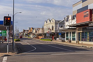
Cessnock is a city in the Hunter Valley of New South Wales, Australia, about 52 km (32 mi) by road west of Newcastle. It is the administrative centre of the City of Cessnock LGA and was named after an 1826 grant of land called Cessnock Estate, which was owned by John Campbell. The local area was once known as "The Coalfields", and it is the gateway city to the vineyards of the Hunter Valley, which includes Pokolbin, Mount View, Lovedale, Broke, Rothbury, and Branxton.
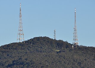
Mount Sugarloaf, also known as Great Sugar Loaf, is a mountain in the lower Hunter Region of New South Wales, Australia, standing at 412 metres, it looks over the cities of Newcastle, Lake Macquarie, Cessnock and Maitland. The summit of the mountain is in the Lake Macquarie suburb of West Wallsend and access to the summit is gained via this suburb. However, the mountain itself is also part of the city of Cessnock suburbs Mulbring and Richmond Vale. It is home to television transmitters that broadcast to the lower Hunter region. On 18 and 19 July 1965, the mountain received 10 centimetres (4 in) of snow. It also snowed on the summit in the winter of 1975.
Denman is a small town in New South Wales, Australia, in Muswellbrook Shire. It is on the Golden Highway in the Upper Hunter Region, about 250 kilometres (160 mi) north of Sydney. At the 2016 census, Denman had a population of 1,789.

Greta is a small town in the Hunter Region of New South Wales, Australia.
Bucketty is a locality in the City of Cessnock local government area (LGA), in New South Wales, Australia. It is in the south of the LGA, immediately adjacent to the border with the City of Hawkesbury and Central Coast Council, in the Hunter Region, about 105 km (65 mi) north of Sydney, and 55 km (34 mi) from Cessnock, New South Wales, the council seat. Bucketty is presumably the Aboriginal word for mountain spring.
Broke is a village of approximately 292 people in the Hunter Region of New South Wales, Australia in Singleton Shire. It is located 157 kilometres (98 mi) to the north of Sydney on the original early colonial road from Sydney to Singleton.
Pokolbin is a rural locality in the Hunter Region of New South Wales Australia. It is part of the Singleton Council local government area and the city of Cessnock. The area is the centre of the Lower Hunter Valley wine region. Pokolbin lies within the Hunter Valley Important Bird Area.
Rothbury is a small town located in the Hunter Region of New South Wales, Australia. It is 10 km from Cessnock. At the 2011 census, Rothbury had a population of 452 people. North Rothbury is another small settlement about 5km to the northeast. The town is 8 km from Pokolbin's vineyards.
Somersby is a semi-rural locality of the Central Coast region of New South Wales, Australia, to the northwest of Gosford along the Pacific Highway. It is part of the Central Coast Council local government area.
Brunkerville is a rural locality in the Hunter Region, New South Wales, Australia. Brunkerville is a part of Cessnock City area, and has the East Maitland postcode, 2323. Geographically, Brunkerville consists of rolling country hills and is flanked by the Watagan and Sugarloaf Mountain Ranges.
Buchanan is a locality in the City of Maitland and City of Cessnock, New South Wales, Australia. It is approximately half farmland and half forested. It was notable as being the intersection of the roads between Maitland, Beresfield, Kurri and Edgeworth. It is the preferred location for a regional freight hub. In 2016, the population was 197, median age was 41 and 85% were born in Australia.
Mount View High School is a government-funded co-educational comprehensive secondary day school, located in West Cessnock, in the Hunter Region of New South Wales, Australia.

Wollombi is a small village in the Hunter Region of New South Wales, Australia. It is within the Cessnock City Council LGA, situated 29 kilometres (18 mi) southwest of Cessnock and 128 km (80 mi) north of Sydney. To the south is the village of Laguna, to the east, the village of Millfield and to the north, the village of Broke.

Mulbring is a village in the Hunter Region of New South Wales, Australia. At the 2016 census, Mulbring recorded a population of 597.

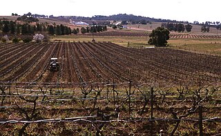
The Hunter Valley is one of Australia's wine regions. Located in the state of New South Wales and first cultivated in the early 19th century, it was one of the first Australian wine regions. As well as Hunter Valley Sémillon, the region produces wine from a variety of grapes including Shiraz, Chardonnay, Cabernet Sauvignon and Verdelho.
North Rothbury is a small town located in the Hunter Region of New South Wales, Australia. It is 19 km from Cessnock. In the 2016 Australian Census the suburb was home to 898 people. Rothbury is another small settlement roughly 5km to the southwest.

Ellalong 'The Jewel of the Mountain' is a small town located in the Hunter Region of New South Wales, Australia at the foot of the Watagan Mountains.
Cedar Creek, a perennial stream of the Hunter River catchment, is located in the Hunter district of New South Wales, Australia.
