East Maitland, New South Wales

Last updated

East Maitland
Maitland,  New South Wales
Australia New South Wales location map blank.svg
Red pog.svg
East Maitland
Coordinates 32°45′6″S151°35′24″E / 32.75167°S 151.59000°E / -32.75167; 151.59000
Population11,860 (2021 census) [1]
 • Density744.0/km2 (1,927.1/sq mi)
Postcode(s) 2323
Area15.94 km2 (6.2 sq mi)
Location
LGA(s) City of Maitland
Region Hunter
State electorate(s) Maitland
Federal division(s) Hunter
Suburbs around East Maitland:
Horseshoe Bend Lorn Tenambit
South Maitland East Maitland Chisholm
Louth Park Ashtonfield Metford

East Maitland is a suburb in Maitland, New South Wales, Australia. It is on the New England Highway and it has two railway stations, Victoria Street and East Maitland. [2] Both stations are served by NSW TrainLink. Hunter Valley Buses provides bus service.

Contents

The traditional owners and custodians of the Maitland area are the Wonnarua people. [3]

Commercial areas

Green Hills is a major commercial district called which includes the large Stockland Green Hills and The Pavilion which features Aldi, Rebel, Repco and the East Maitland Library.

There are also shops near Victoria Street railway station.

Schools

Pitnacree Bridge

Opened to cross the Hunter River in 1866. [9] It was located on Pitnacree Road to the Harry Boyle Bridge around 500 meters north east. [9] It was designed as people can travel from Woodville to East Maitland. [9] In 1951 flooding changed the course of the river meaning the bridge was no longer used. [9] It was demolished in 1962 with no above evidence of its existence. [9]

Population

According to the 2016 census of Population, there were 11,782 people in East Maitland.

Heritage listings

View along King Street of three heritage-listed properties 297 - Terrace (5045650b5).jpg
View along King Street of three heritage-listed properties

East Maitland has a number of heritage-listed sites, including:

History

The traditional and custodians of the land are the Wonnarua people. [3]

Approximately 1818 were when the first European settlers arrived. Maitland was central to trade and the growth of the Hunter Region.

Tom White Melville Winder was one of the largest proprietors on the Hunter [24] . Winder held 7400 acres (2995 ha) by 1828 and by 1831 had acquired another 2600 acres (1052 ha). The area of the land grants [25] included areas in the Maitland LGA.

The “Windermere” estate including the grounds were where a cedar forest was used for building materials and other logs were sent along the Hunter River to trade and send cedars to England and Sydney. Windermere estate was established before East Maitland and West Maitland were established [26] . Windermere was a hub for cedar trade with Winder having his own fleet of vessels

The history of Maitland is reflected in the buildings including government buildings being established. There are many historic and heritage buildings in the area. Many of these buildings show evidence of the abundant cedar timbers in the area, using these for buildings and furniture. Buildings also use local sandstone.

Maitland grew steadily and quickly became an important regional centre in the Colony. Growth was rapid but recent growth was slower once sea routes were taken over by rail/road routes as preferred modes of transportation. Also original supplies such cedars were used/depleted and other areas of Australia were opened up. Also the waterways today are lessened in size/volume with many formerly abundant creeks dried up or now small drains unable to be traversed by boat.

Notable people

Related Research Articles

<span class="mw-page-title-main">Parramatta</span> City in New South Wales, Australia

Parramatta is a satellite city of Sydney, Australia's largest city and the capital of New South Wales. It is the primary central business district (CBD) for Greater Western Sydney, located approximately 24 kilometres (15 mi) west of Central Sydney, on the banks of the Parramatta River.

<span class="mw-page-title-main">Maitland, New South Wales</span> City in New South Wales, Australia

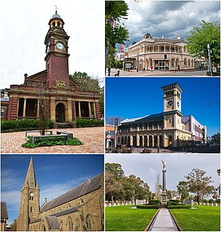
Maitland is a city in the Hunter Valley of New South Wales, Australia and the seat of Maitland City Council, situated on the Hunter River approximately 166 kilometres (103 mi) by road north of Sydney and 35 km (22 mi) north-west of Newcastle. It is on the New England Highway approximately 17 km (11 mi) from its origin at Hexham.

<span class="mw-page-title-main">Goulburn</span> City in New South Wales, Australia

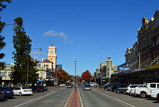
Goulburn is a regional city in the Southern Tablelands of the Australian state of New South Wales, approximately 195 kilometres (121 mi) south-west of Sydney, and 90 kilometres (56 mi) north-east of Canberra. It was proclaimed as Australia's first inland city through letters patent by Queen Victoria in 1863. Goulburn had a population of 24,565 at June 2021. Goulburn is the seat of Goulburn Mulwaree Council.

<span class="mw-page-title-main">Richmond, New South Wales</span> Town in New South Wales, Australia


Richmond is a historic town in north-west of Sydney, New South Wales, Australia. Richmond is in local government area of City of Hawkesbury and comes under Sydney Metropolitan area. It is located 20 metres above sea level on the alluvial Hawkesbury River flats, at the foot of the Blue Mountains. It is about 65 km by road from Sydney, 22 km from Penrith, 26 km from Blacktown, 40 km from Parramatta, 78 km from Lithgow and 5 km from Windsor. Richmond Town is now part of Sydney urban area have all amenities including Shopping Malls, Service NSW, Schools, TAFE, University, Post Office, Restaurants, Railway Station, Cafe, Hotel and Supermarkets.

<span class="mw-page-title-main">The Rocks, New South Wales</span> Suburb of Sydney, New South Wales, Australia

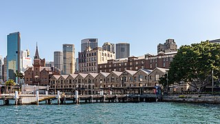
The Rocks is a suburb, tourist precinct and historic area of Sydney's city centre, in the state of New South Wales, Australia. It is located on the southern shore of Sydney Harbour, immediately north-west of the Sydney central business district.

<span class="mw-page-title-main">Wahroonga, New South Wales</span> Suburb of Sydney, New South Wales, Australia

Wahroonga is a suburb in the Upper North Shore of Sydney, in the state of New South Wales, Australia, 18 kilometres north-west of the Sydney central business district, in the local government areas of Ku-ring-gai Council and Hornsby Shire. North Wahroonga is an adjacent separate suburb of the same postcode.

<span class="mw-page-title-main">City of Blue Mountains</span> Local government area in New South Wales, Australia

The City of Blue Mountains is a local government area of New South Wales, Australia, governed by the Blue Mountains City Council. The city is located in the Blue Mountains, on the Great Dividing Range at the far western fringe of the Greater Sydney area.

<span class="mw-page-title-main">North Sydney Council</span> Local government area in New South Wales, Australia

North Sydney Council is a local government area on the Lower North Shore of Sydney, New South Wales, Australia, established on 29 July 1890 through the amalgamation of three boroughs.

<span class="mw-page-title-main">Millers Point, New South Wales</span> Suburb of Sydney, New South Wales

Millers Point is an inner-city suburb of Sydney, in the state of New South Wales, Australia. It is on the north-western edge of the Sydney central business district, adjacent to The Rocks and is part of the local government area of the City of Sydney.

<span class="mw-page-title-main">Morpeth, New South Wales</span> Suburb of Maitland, New South Wales, Australia

Morpeth is a suburb of the city of Maitland in the Hunter Region of New South Wales, Australia. It is on the southern banks of the Hunter River at the border between the City of Maitland and Port Stephens Council LGAs. The major population centre, where almost all residents of the suburb reside, is the historical town of Morpeth which takes its name from Morpeth, Northumberland, near Newcastle upon Tyne, in England.

<span class="mw-page-title-main">Victoria Street railway station, New South Wales</span> Railway station in New South Wales, Australia

Victoria Street railway station is a heritage-listed railway station located on the Main Northern line in New South Wales, Australia. It serves the Victoria Street area of East Maitland. It was added to the New South Wales State Heritage Register on 2 April 1999.

<span class="mw-page-title-main">Tamworth Regional Council</span> Local government area in New South Wales, Australia

Tamworth Regional Council is a local government area in the New England region of New South Wales, Australia. The area under administration is located adjacent to the New England Highway and the Main North railway line. It was established in March 2004 through the amalgamation of the former City of Tamworth with surrounding shires of Barraba, Manilla, Nundle and Parry.

<span class="mw-page-title-main">City of Lithgow</span> Local government area in New South Wales, Australia

The City of Lithgow is a local government area in the Central West region of New South Wales, Australia. The area is located adjacent to the Great Western Highway and the Main Western railway line.

<span class="mw-page-title-main">City of Orange (New South Wales)</span> Local government area in New South Wales, Australia

The City of Orange is a local government area in the Central West region of New South Wales, Australia. Based in Orange, the area is located adjacent to the Mitchell Highway and the Main Western railway line.

<span class="mw-page-title-main">Walter Liberty Vernon</span> English architect

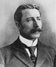
Colonel Walter Liberty Vernon was an English architect who migrated to Australia and pursued his career as an architect in Sydney, New South Wales. In his role as the New South Wales Government Architect he is noted for designing multiple government buildings, many of which are extant with listings on national and state heritage registers.

<span class="mw-page-title-main">George McRae</span> Scottish-Australian architect

George McRae was a Scottish-Australian architect who migrated from his native Edinburgh to Sydney, where he became Government Architect of New South Wales and designed some of Sydney's best-known buildings, including completion of the Sydney Town Hall, the Queen Victoria Building, and the lower entrance to Taronga Zoo.

<span class="mw-page-title-main">Sussex Street, Sydney</span> Street in Sydney, Australia

Sussex Street is a street in the central business district of Sydney in New South Wales, Australia. It runs north-south along the western side of the city, between Hickson Road and Hay Street. It is in the local government area of the City of Sydney. The street is 1.7 kilometres (1.1 mi) long. It was named in honour of Prince Augustus Frederick, Duke of Sussex, the sixth son of King George III.

<span class="mw-page-title-main">Armidale Regional Council</span> Local government area in New South Wales, Australia

The Armidale Region is a local government area in the New England and Northern Tablelands regions of New South Wales, Australia. This area was formed in 2016 from the merger of the Armidale Dumaresq Shire with the surrounding Guyra Shire.

<span class="mw-page-title-main">Snowy Valleys Council</span> Local government area in New South Wales, Australia

The Snowy Valleys Council is a local government area located in the South West Slopes region of New South Wales, Australia. This area was formed in 2016 from the merger of the Tumut Shire with the neighbouring Tumbarumba Shire.

<span class="mw-page-title-main">Dubbo Regional Council</span> Local government area in New South Wales, Australia

The Dubbo Regional Council is a local government area located in the Central West and Orana regions of New South Wales, Australia. The council was formed on 12 May 2016 through a merger of the City of Dubbo and Wellington Council as part of a widespread council amalgamation program. It was initially named Western Plains Regional Council for almost four months, and its name was changed to Dubbo Regional Council on 7 September 2016.

References

  1. Australian Bureau of Statistics (28 June 2022). "East Maitland (State Suburb)". 2021 Census QuickStats. Retrieved 5 June 2023. OOjs UI icon edit-ltr-progressive.svg
  2. "Main North Line". www.nswrail.net. Retrieved 22 November 2006.
  3. 1 2 "Aboriginal and Torres Strait Islander Peoples". Maitland City Council. Retrieved 8 September 2020.
  4. Schoolzine; Schoolzine. "St Joseph's Primary School East Maitland Website". St Joseph's Primary School East Maitland Website. Retrieved 7 October 2020.
  5. "Home - East Maitland Public School". maitlande-p.schools.nsw.gov.au. Retrieved 7 October 2020.
  6. admin. "Home". Linuwel School. Retrieved 7 October 2020.
  7. "Home - Maitland High School". maitland-h.schools.nsw.gov.au. Retrieved 7 October 2020.
  8. "Home - Maitland Grossmann High School". maitgross-h.schools.nsw.gov.au. Retrieved 7 October 2020.
  9. 1 2 3 4 5 "Pitnacree Bridge". www.patersonriver.com.au. Retrieved 23 February 2021.
  10. Australian Bureau of Statistics (27 June 2017). "East Maitland (State Suburb)". 2016 Census QuickStats. Retrieved 29 March 2018. OOjs UI icon edit-ltr-progressive.svg
  11. "Post Office & Stables (former)". New South Wales State Heritage Register . Department of Planning & Environment. H00494. Retrieved 18 May 2018. CC BY icon.svg Text is licensed by State of New South Wales (Department of Planning and Environment) under CC-BY 4.0 licence .
  12. "Maitland Correctional Centre". New South Wales State Heritage Register . Department of Planning & Environment. H01296. Retrieved 18 May 2018. CC BY icon.svg Text is licensed by State of New South Wales (Department of Planning and Environment) under CC-BY 4.0 licence .
  13. "Police Station (East Maitland)". New South Wales State Heritage Register . Department of Planning & Environment. H01016. Retrieved 18 May 2018. CC BY icon.svg Text is licensed by State of New South Wales (Department of Planning and Environment) under CC-BY 4.0 licence .
  14. "Terrace". New South Wales State Heritage Register . Department of Planning & Environment. H00297. Retrieved 18 May 2018. CC BY icon.svg Text is licensed by State of New South Wales (Department of Planning and Environment) under CC-BY 4.0 licence .
  15. "Goonoobah & Woodlands". New South Wales State Heritage Register . Department of Planning & Environment. H00298. Retrieved 18 May 2018. CC BY icon.svg Text is licensed by State of New South Wales (Department of Planning and Environment) under CC-BY 4.0 licence .
  16. "Woodlands". New South Wales State Heritage Register . Department of Planning & Environment. H00299. Retrieved 18 May 2018. CC BY icon.svg Text is licensed by State of New South Wales (Department of Planning and Environment) under CC-BY 4.0 licence .
  17. "East Maitland Railway Station group". New South Wales State Heritage Register . Department of Planning & Environment. H01135. Retrieved 18 May 2018. CC BY icon.svg Text is licensed by State of New South Wales (Department of Planning and Environment) under CC-BY 4.0 licence .
  18. "Victoria Street Railway Station group". New South Wales State Heritage Register . Department of Planning & Environment. H01277. Retrieved 18 May 2018. CC BY icon.svg Text is licensed by State of New South Wales (Department of Planning and Environment) under CC-BY 4.0 licence .
  19. "Caroline Chisholm Cottage". New South Wales State Heritage Register . Department of Planning & Environment. H00500. Retrieved 18 May 2018. CC BY icon.svg Text is licensed by State of New South Wales (Department of Planning and Environment) under CC-BY 4.0 licence .
  20. "Smith's Flour Mill (former)". New South Wales State Heritage Register . Department of Planning & Environment. H00237. Retrieved 18 May 2018. CC BY icon.svg Text is licensed by State of New South Wales (Department of Planning and Environment) under CC-BY 4.0 licence .
  21. "Englefield". New South Wales State Heritage Register . Department of Planning & Environment. H01772. Retrieved 18 May 2018. CC BY icon.svg Text is licensed by State of New South Wales (Department of Planning and Environment) under CC-BY 4.0 licence .
  22. "Oldholme". New South Wales State Heritage Register . Department of Planning & Environment. H00136. Retrieved 18 May 2018. CC BY icon.svg Text is licensed by State of New South Wales (Department of Planning and Environment) under CC-BY 4.0 licence .
  23. "St. Peter's Anglican Church Group and Glebe Cemetery". New South Wales State Heritage Register . Department of Planning & Environment. H01886. Retrieved 18 May 2018. CC BY icon.svg Text is licensed by State of New South Wales (Department of Planning and Environment) under CC-BY 4.0 licence .
  24. "Tom White Melville Winder - Hungerford & Associated Families Society". 8 February 2019. Retrieved 17 April 2024.
  25. "The Winder Family [W] - Hungerford & Associated Families Society". 4 June 2017. Retrieved 17 April 2024.
  26. The University of Newcastle. "Windermere - A Gracious Reminder of Bygone Days" (PDF). UniNews. pp. 4–5.