
The National Highway is a system of roads connecting all mainland states and territories of Australia, and is the major network of highways and motorways connecting Australia's capital cities and major regional centres.

Pacific Highway is a 790-kilometre-long (491 mi) national highway and major transport route along the central east coast of Australia, with the majority of it being part of Australia's Highway 1. The highway and its adjoining Pacific Motorway between Brisbane and Brunswick Heads and Pacific Motorway between Sydney and Newcastle links the state capitals of Sydney in New South Wales with Brisbane in Queensland, approximately paralleling the Tasman Sea and the Coral Sea of the South Pacific Ocean coast, via regional cities and towns like Gosford, Newcastle, Taree, Port Macquarie, Kempsey, Coffs Harbour, Grafton, Ballina, Byron Bay, Tweed Heads and the Gold Coast, which is part of Queensland. Additionally, between Brunswick Heads and Port Macquarie, the road is also signed as Pacific Motorway, but has not been legally gazetted as such.
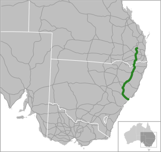
New England Highway is an 883-kilometre (549 mi) long highway in Australia running from Yarraman, north of Toowoomba, Queensland, at its northern end to Hexham at Newcastle, New South Wales, at its southern end. It is part of Australia's National Highway system, and forms part of the inland route between Brisbane and Sydney.
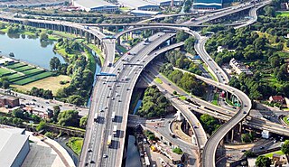
Spaghetti junction is a nickname sometimes given to a complex or massively intertwined road traffic interchange that is said to resemble a plate of spaghetti. Such interchanges may incorporate a variety of interchange design elements in order to maximize connectivity.

The A9 is a route designation of the outer western Sydney Bypass, connecting Windsor to Campbelltown via Penrith. This name covers a few consecutive roads and is widely known to most drivers, but the entire allocation is also known – and signposted – by the names of its constituent parts: Macquarie Street, George Street, The Northern Road, Richmond Road, Parker Street and Narellan Road.

Princes Motorway is a 62-kilometre (39 mi) predominantly dual carriage untolled motorway that links Sydney to Wollongong and further south through the Illawarra region to Oak Flats. Part of the Australian Highway 1 network, the motorway is designated route M1.

A limited-access road, known by various terms worldwide, including limited-access highway, dual-carriageway, expressway, and partial controlled-access highway, is a highway or arterial road for high-speed traffic which has many or most characteristics of a controlled-access highway, including limited or no access to adjacent property, some degree of separation of opposing traffic flow, use of grade separated interchanges to some extent, prohibition of slow modes of transport, such as bicycles, (draught) horses, or self-propelled agricultural machines; and very few or no intersecting cross-streets or level crossings. The degree of isolation from local traffic allowed varies between countries and regions. The precise definition of these terms varies by jurisdiction.

The Pacific Motorway is a motorway in Australia between Brisbane, Queensland, and Brunswick Heads, New South Wales, through the New South Wales–Queensland border at Tweed Heads.

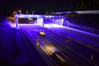
A controlled-access highway is a type of highway that has been designed for high-speed vehicular traffic, with all traffic flow—ingress and egress—regulated. Common English terms are freeway, motorway and expressway. Other similar terms include throughway and parkway. Some of these may be limited-access highways, although this term can also refer to a class of highways with somewhat less isolation from other traffic.

M1 Pacific Motorway is a 127-kilometre motorway linking Sydney to Newcastle via the Central Coast and Hunter regions of New South Wales. Formerly known but still commonly referred to by both the public and the government as the F3 Freeway, Sydney–Newcastle Freeway, and Sydney–Newcastle Expressway, it is part of the AusLink road corridor between Sydney and Brisbane.
M2 Hills Motorway is a 19.3-kilometre (12.0 mi) tolled urban motorway in Sydney, New South Wales that is part of the Sydney Orbital Network and the National Highway west of Pennant Hills Road. Owned by toll road operator Transurban, it forms majority of Sydney's M2 route, with the Lane Cove Tunnel constituting the rest of the M2 route.

The M4 Motorway is a 55-kilometre (34 mi) series of partially-tolled dual carriageway motorways in Sydney, New South Wales designated as route M4. The M4 designation is part of the wider A4 and M4 route designation, the M4 runs parallel and/or below ground to Great Western Highway, Parramatta Road and City West Link, which are part of route A44.
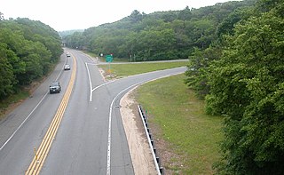
A two-lane expressway or two-lane freeway is an expressway or freeway with only one lane in each direction, and usually no median barrier. It may be built that way because of constraints, or may be intended for expansion once traffic volumes rise. The term super two is often used by roadgeeks for this type of road, but traffic engineers use that term for a high-quality surface road. Most of these roads are not tolled.
Sydney Bypass refers to a number of roads, existing and proposed, that motorists can use to avoid the congested approaches to the Sydney central business district (CBD). The main bypasses are:
The North Western Expressway and the Lane Cove Valley Expressway was a planned but later cancelled freeway route in Sydney, New South Wales, Australia, intended to link the Sydney central business district to its north-western suburbs, and ultimately the Sydney–Newcastle Freeway to Newcastle. The entirety of the Sydney to Newcastle route was to be known as the F3 Freeway, a name that remains as a common name of the Sydney–Newcastle Freeway.

The Mooney Mooney Bridge, officially the Mooney Mooney Creek Bridge, and popularly known as The NSW Big Dipper Bridge, is a twin cantilever bridge that carries the Pacific Motorway (M1) across Mooney Mooney Creek, located near Mooney Mooney in the Brisbane Water National Park on the Central Coast of New South Wales, Australia. The concrete box girder bridge was opened on 14 December 1986 by the Prime Minister of Australia, Bob Hawke, and is owned and maintained by Transport for NSW, an agency of the Government of New South Wales.

The Hunter Expressway is a 39.5-kilometre (24.5 mi) long controlled-access highway in New South Wales, Australia. It was previously known as the F3 to Branxton link or Kurri Kurri Corridor during the planning stage. It has two lanes in each direction, running generally north west from the Pacific Motorway at the Newcastle Link Road interchange to the eastern end of the Belford Bends Deviation on the New England Highway north of Branxton. The road allows traffic to bypass the Maitland area, Lochinvar, Greta and Branxton. The expressway opened on 22 March 2014.
Newcastle Inner City Bypass is a freeway in Newcastle and Lake Macquarie, New South Wales, Australia. Originally cobbled together from a collection of arterial roads, it has been slowly upgraded and lengthened in sections over the years to a motorway-standard bypass through the inner western suburbs of Newcastle.
NorthConnex is a 9-kilometre (5.6 mi) twin-tube motorway tunnel in northern Sydney, New South Wales, Australia, signposted as the M11 Tunnel. It acts as a tunnel bypass of the congested Pennant Hills Road, extending or connecting the M1 Pacific Motorway to the M2 Hills Motorway. Owned by NorthWestern Roads (NWR) Group, it is one of the longest road tunnels in Australia, along with the WestConnex Tunnel. It is also the deepest road tunnel in Australia, with more than half of the tunnel 60 metres (200 ft) deep or more, and the deepest point is underneath the Sydney Metro Northwest, about 90 metres (300 ft) below ground.
