Timber truss road bridges have played a significant role in the expansion and improvement of the NSW road network. Prior to the bridges being built, river crossings were often dangerous in times of rain, which caused bulk freight movement to be prohibitively expensive for most agricultural and mining produce. Only the high priced wool clip of the time was able to carry the costs and inconvenience imposed by the generally inadequate river crossings that often existed prior to the trusses construction.[1]
Timber truss bridges were preferred by the NSW Public Works Department from the mid 19th to the early 20th century because they were relatively cheap to construct, and used mostly local materials. The financially troubled governments of the day applied pressure to the Public Works Department to produce as much road and bridge work for as little cost as possible, using local materials. This condition effectively prohibited the use of iron and steel, as these, prior to the construction of the steel works at Newcastle in the early 20th century, had to be imported from England.[1]
Timber truss bridges, and timber bridges generally were so common that NSW was known to travellers as the "timber bridge state".[1]
Clarence Town bridge
The Clarence Town bridge was built to replace a local ford which was impassable when the river was high.[2] The tender of contractor J. K. Mackenzie was accepted in January 1879, and construction was underway by April that year.[3] Work on the bridge was delayed when a flood carried away and destroyed some of the bridge cylinders before they were in place.[4]
The original bridge was formally opened on 24 May 1880, with the wife of local MP, William Johnston breaking a bottle of wine under an arch.[5]
By 1924, the local council was expressing concern about the "dangerous condition" of the original bridge. The bridge was completely rebuilt in 1926 at a budgeted sum of A£8,000.[1][6] Light traffic had to use an antiquated punt in the interim, while heavy traffic had to use an old ford, resulting in local complaints and demands for the work to be expedited.[7][8] The bridge reopened for traffic in October 1926.[9]
More recently,[when?] cables have been retrofitted to strengthen the bridge structure.[1]
Description
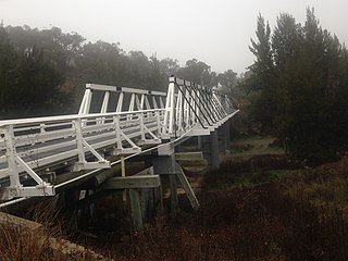
Clarence Town Bridge is an old Public Works Department type timber truss road bridge. It has two timber truss spans, each of 30 metres (100ft). There are three timber approach spans at one end and one at the other giving the bridge an overall length of 116 metres (380ft). The main spans are supported by twin cast iron cylindrical piers braced with iron stiffeners and provides a single-lane carriageway. The minimum width of the carriageway is 4.6 metres (15ft). A timber post and rail guard rail extends the full length of the bridge.[1]
At the time of the study Bailey trusses were located on the bridge for temporary support during major repairs. Cables have been retro-fitted to strengthen the bridge structure.[1]
It was reported to be in a fair condition as at 1998, although having been completely rebuilt, and having had under-cables added for support.[1]
Heritage listing
The Clarence Town bridge is an Old Public Works Department (Old PWD) type timber truss road bridge, which was completed in 1880, and was completely rebuilt in 1926/7. In 1998 it was in a fair condition.[1]
As a timber truss road bridge, it has many associational links with important historical events, trends, and people, including the expansion of the road network and economic activity throughout NSW, and William Bennett, the Commissioner for Public Works responsible for construction of many of the bridges.[1]
Old PWD trusses were the first in the five-stage development of NSW timber truss bridges. Constructed from timber to conform with the 1861 parliamentary decree that local materials should be used in public works, the trusses took advantage of the high quality hardwood that was available in NSW. The design is essentially a copy of the European timber truss bridges that had their origins in the work of the 16th century Italian architect Andrea Palladio.[1]
Clarence Town Bridge is located in the Hunter region, which has 15 historic bridges each constructed before 1905, and it gains heritage significance from its proximity to the high concentration of other historic bridges in the area.[1]
In 1998 there were two surviving Old PWD trusses in NSW of the 147 built, and 82 timber truss road bridges survive from the over 400 built. The Clarence Town Bridge is the oldest surviving timber truss bridge in NSW.[1]
The Clarence Town bridge is a representative and rare example of Old PWD timber truss road bridges, and is assessed as being Nationally significant, primarily on the basis of its technical and historical significance.[1]
The place is important in demonstrating the course, or pattern, of cultural or natural history in New South Wales.
Through the bridge's association with the expansion of the NSW road network, its ability to demonstrate historically important concepts such as the gradual acceptance of NSW people of American design ideas, and its association with William Bennett, it has historical significance.[1]
The place is important in demonstrating aesthetic characteristics and/or a high degree of creative or technical achievement in New South Wales.
The bridge exhibits the technical excellence of its design, as all of the structural detail is clearly visible. In the context of its landscape it is visually attractive. As such, the bridge has moderate aesthetic significance.[1]
The place has strong or special association with a particular community or cultural group in New South Wales for social, cultural or spiritual reasons.
Timber truss bridges are prominent to road travellers, and NSW has in the past been referred to as the "timber truss bridge state". Through this, the complete set of bridges gain some social significance, as they could be said to be held in reasonable esteem by many travellers in NSW. The Clarence Town Bridge is valued by the people of the Hunter region.[1]
The place possesses uncommon, rare or endangered aspects of the cultural or natural history of New South Wales.
The bridge is highly rare, as it is one of only two old PWD design bridges to survive out of 147 built.[1]
The place is important in demonstrating the principal characteristics of a class of cultural or natural places/environments in New South Wales.
The bridge is highly representative of a once prolific form of construction.[1]
Dungog is a country town on the Williams River in the Hunter Region of New South Wales, Australia. Located in the middle of dairy and timber country, it is the centre of the Dungog Shire local government area and at the 2016 census it had a population of 2,025 people. The area includes the Fosterton Loop, 22 kilometres (14 mi) of road, used in the annual Pedalfest. A small portion of Dungog lies in the Mid-Coast Council LGA.
Clarence Town is both a primarily rural locality and a township in the Dungog Shire local government area in the Hunter Region of New South Wales, Australia. It is 193 kilometres (120 mi) north of Sydney, 54 km (34 mi) north-north-west of Newcastle, and 28 km (17 mi) from the Pacific Highway at Raymond Terrace. The locality is bisected by the Williams River. The township sits just to the west of the river about 32 km (20 mi) upstream from where it flows into the Hunter River at Raymond Terrace.
The Victoria Bridge is a heritage-listed timber trestle truss road bridge across the Stonequarry Creek, located at Prince Street in the south-western Sydney town of Picton in the Wollondilly Shire local government area of New South Wales, Australia. The bridge is owned by Transport for NSW, an agency of the Government of New South Wales. The bridge is also known as the Victoria Bridge over Stonequarry Creek. It was added to the New South Wales State Heritage Register on 20 June 2000. Designed by Percy Allan and opened on 7 October 1897, Victoria Bridge employs Allan trusses and was built by C. J. Ford of Sydney.
The Williams River is a perennial stream that is a tributary of the Hunter River, in the Hunter Region of New South Wales, Australia.
This list documents historical bridges located in New South Wales, Australia. Road, rail and pedestrian bridges are listed. Generally bridges built before WWII (1939) have been included in this list.
Morpeth Bridge is a heritage-listed road bridge over the Hunter River at Morpeth, New South Wales, Australia. It was designed by Percy Allan and built from 1896 to 1898 by Samuel McGill. It is also known as Morpeth Bridge over the Hunter River. The property is owned by Transport for NSW.
The Wallaby Rocks Bridge is a heritage-listed road bridge that carries Hill End Road across the Turon River, at Wallaby Rocks near Sofala, New South Wales, Australia. It was designed by Percy Allan and built in 1897 by E. Taylor of Balmain. The bridge is owned by Transport for NSW. It was added to the New South Wales State Heritage Register on 20 June 2000.
Old Cobram-Barooga Bridge is a heritage-listed former road bridge and now footbridge over the Murray River at Barooga-Cobram Road, Barooga, New South Wales, Australia. The bridge links Barooga with Cobram, its sister town in Victoria. It was designed by Ernest de Burgh (engineer) and the New South Wales Department of Public Works and built from 1900 to 1902. It is also known as RMS Bridge No 3247. It is owned by Transport for NSW. It was added to the New South Wales State Heritage Register on 1 April 2016.
The Tooleybuc Bridge is a dual heritage-listed road bridge that carries Tooleybuc Road across the Murray River, located in Tooleybuc, New South Wales, Australia. It was built in 1925. The bridge is owned by the Transport for NSW, and is also called the Tooleybuc Bridge over Murray River. The bridge was added to the New South Wales State Heritage Register on 20 June 2000 and the Victorian Heritage Register on 10 July 2008.
The Paterson River bridge, Vacy is a heritage-listed road bridge that carries Gresford Road across the Paterson River located in Vacy, New South Wales, Australia. The bridge was designed by Percy Allan and built in 1888 by Taylor and Littleproud. The bridge is also known as the Vacy Bridge over Paterson River. The bridge is owned by Transport for NSW. It was added to the New South Wales State Heritage Register on 20 June 2000.
The Cooreei Bridge over Williams River is a heritage-listed road bridge that carries Main Road across Williams River in Dungog, New South Wales, Australia. The property is owned by Transport for NSW. It was added to the New South Wales State Heritage Register on 20 June 2000.
The Karuah River bridge is a heritage-listed road bridge that carries the Weismantels-Dingadee Road across the Karuah River, located at Monkerai, New South Wales, Australia. The bridge is also known as the Monkerai Bridge over Karuah River. The bridge is owned by Transport for NSW. It was added to the New South Wales State Heritage Register on 20 June 2000.
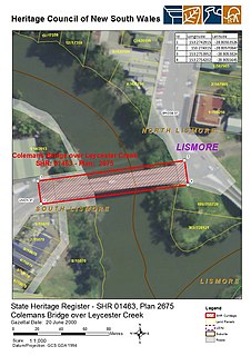
The Colemans Bridge is a heritage-listed road bridge that carries Union Street across the Leycester Creek in Lismore, New South Wales, Australia. It was designed by Harvey Dare and built in 1907 by W. F. Oakes. The bridge is owned by Transport for NSW. It was added to the New South Wales State Heritage Register on 20 June 2000.
The Dunmore Bridge is a heritage-listed road bridge that carries Clarence Town Road across the Paterson River in Woodville, New South Wales, Australia. It was designed by Percy Allan and built in 1899 by Morpeth contractor, S. McGill. The property is owned by Transport for NSW. It was added to the New South Wales State Heritage Register on 20 June 2000.
The Hinton Bridge over Paterson River is a heritage-listed road bridge that carrier the Hinton-Morpeth Road across the Paterson River at Hinton, New South Wales, Australia. The bridge was designed by Ernest de Burgh and built in 1901. The bridge is owned by Transport for NSW. The bridge was added to the New South Wales State Heritage Register on 20 June 2000.
The McKanes Falls Bridge is a heritage-listed road bridge at McKanes Falls Road, South Bowenfels, New South Wales, Australia. It was designed by John McDonald and NSW Engineer for Bridges and built from 1892 to 1893 by NSW Public Works. It is also known as McKanes Bridge. The property is owned by Transport for NSW. It was added to the New South Wales State Heritage Register on 20 June 2000.
The MacDonald River bridge is a heritage-listed road bridge that carries St Albans Road across the MacDonald River at St Albans, New South Wales, Australia. It was designed by Ernest de Burgh and built by John Ahearn and Son. It is also known as Norton Bridge. The property is owned by Transport for NSW. It was added to the New South Wales State Heritage Register on 20 June 2000.
Beckers Bridge is a heritage-listed timber truss road bridge that carries Main Road across Webbers Creek, located in Glendon Brook, New South Wales, Australia. It was designed by Ernest de Burgh. The Bridge is owned by Transport for NSW. It was added to the New South Wales State Heritage Register on 20 June 2000.
The Glennies Creek Bridge is a heritage-listed road bridge that carries the Rixs Creek-Falbrook Road across the Glennies Creek, located at Middle Falbrook, New South Wales, Australia. The bridge was designed by Ernest de Burgh and built in 1902-03 by William Murphy and James Taylor. The property is owned by Transport for NSW. The bridge was added to the New South Wales State Heritage Register on 20 June 2000.
The Wollombi Brook bridge is a heritage-listed road bridge that carries Putty Road across the Wollombi Brook at Bulga, New South Wales, Australia. The bridge was designed by Harvey Dare and built in 1912. The bridge is owned by Transport for NSW. The bridge was added to the New South Wales State Heritage Register on 20 June 2000.
Eco Images (2008). Clarence Town Bridge capacity improvement works: archival photographic recording of heritage item.
RTA. Proposed rehabilitation and strengthening works on Clarence Town Bridge over the Williams River South of Dungog, NSW: statement of heritage impact.
This page is based on this Wikipedia article Text is available under the CC BY-SA 4.0 license; additional terms may apply. Images, videos and audio are available under their respective licenses.