Federal Highway (Australia)

Last updated

Federal Highway

Australian Capital Territory
Federal Highway, Wollogorang.jpg
Southbound carriageway, at Wollogorang. The median strip at this location is about 200 metres (656 ft) [1] wide and contains pasture.
Australia New South Wales location map blank.svg
Red pog.svg
Northeast end
Red pog.svg
Southwest end
Coordinates
General information
Type Motorway
Length72.7 km (45 mi) [2]
OpenedFebruary 1931 [3]
Gazetted August 1928 (NSW, as Main Road 3) [4]
Maintained by
Route number(s)
  • AUS Alphanumeric Route M23.svg M23 (2013–present)
    (Yarra–NSW/ACT border)
  • New South Wales alphanumeric route M23.svg M23 (2016–present)
    (ACT/NSW border–Majura)
  • New South Wales alphanumeric route A23.svg A23 (2013–present)
    (Majura–Lyneham)
Former
route number
  • New South Wales alphanumeric route A23.svg A23 (2013–2016)
    (ACT/NSW border–Majura)
  • Australian national highway 23.svg National Highway 23
    (1974–2013, within NSW)
  • Australian national highway ACT 23.svg National Highway 23
    (1974–2013, within ACT)
  • Australian national route 23.svg National Route 23
    (1955–1974)
Major junctions
Northeast endAUS Alphanumeric Route M31.svg Hume Highway
Yarra, New South Wales
 
Southwest endNew South Wales alphanumeric route A23.svg Northbourne Avenue
Lyneham, Australian Capital Territory
Location(s)
Region Southern Tablelands
LGA(s) Goulburn Mulwaree Council, Upper Lachlan Shire, Queanbeyan-Palerang Regional Council, Yass Valley Shire, Australian Capital Territory
Major suburbs / towns Collector, Sutton, Watson, Downer, Lyneham
Highway system

Federal Highway is a highway in New South Wales and the Australian Capital Territory. It is a part of a motorway-standard link between Sydney and Canberra, and is also the main thoroughfare between those cities.

Contents

The north-eastern end of Federal Highway is located at its junction with Hume Highway near the rural city of Goulburn. It runs 72.7 km (45.2 mi) southwest to Canberra, the national capital of Australia, where its southwestern end is located at the intersection of Northbourne Avenue and Barton Highway. Federal Highway passes the villages of Wollogorang, Collector and Sutton, as well as skirting the western side of the endorheic basin containing Lake George.

Route

Federal Highway is a motorway-standard roadway linking from the interchange with Hume Highway at Yarra, southeast of Goulburn, to Canberra in the Australian Capital Territory. The roadway has a continuous 110 km/h (68 mph) speed limit within New South Wales northbound. A southbound section between the Great Dividing Range, south of Yarra, and Rowes Lagoon, north of Collector, is on an old and winding alignment and has a speed limit of 100k/h with many lower advisory speed signs. Within the Australian Capital Territory the posted speed limit is 100 km/h (62 mph) between the State-border and Antill Street, 80 km/h (50 mph) between Antil Street and Flemington Road, and 70 km/h (43 mph) between Flemington Road and the end of the road at Barton Highway (where the road runs parallel with the Canberra Metro light rail route). The entire length of the roadway is dual carriageway with 2 lanes in each direction.

History

In New South Wales, the passing of the Main Roads Act of 1924 [5] through the Parliament of New South Wales provided for the declaration of Main Roads, roads partially funded by the State government through the Main Roads Board (later the Department of Main Roads, and eventually Transport for NSW). The New South Wales section of Federal Highway was declared (as Main Road No. 3) on 8 August 1928, from its interchange with Hume Highway in Yarra, via Collector and Geary's Gap, to the interstate border; [4] with the passing of the Main Roads (Amendment) Act of 1929 [6] to provide for additional declarations of State Highways and Trunk Roads, this was amended to State Highway 3 on 8 April 1929. Construction had already been completed and traffic was already using the portion of the highway within New South Wales by December 1930. [7]

In the Federal Capital Territory, the local Sydney-Canberra Road was officially declared part of Federal Highway in September 1928. [8] Surveying and levelling had finished and work had started in April 1929 [9] to connect to the NSW portion of the road, with the contract awarded to John Fowler (Aust) Ltd, to construct a 6-mile section of highway from Canberra (today Lyneham) to the interstate boundary. [10] Approaching completion by February 1930, [11] it was officially completed and opened on 25 February 1931. [3]

The passing of the Roads Act of 1993 [12] through the Parliament of New South Wales updated road classifications and the way they could be declared within New South Wales. Under this act, Federal Highway today retains its declaration as Highway 3, from Yarra to the interstate border with the ACT. [13]

Federal Highway was allocated National Route 23 across its entire length in 1955. The Whitlam government introduced the federal National Roads Act 1974, [14] where roads declared as a National Highway were still the responsibility of the states for road construction and maintenance, but were fully compensated by the Federal government for money spent on approved projects. [14] :S7 As an important interstate link between the capitals of New South Wales and the Australian Capital Territory, the Federal Highway was declared a National Highway in 1974 and was consequently re-allocated National Highway 23. [15] With the conversion to the newer alphanumeric system in 2013, this was replaced with route M23 across the New South Wales' section, [16] and route A23 across the Australian Capital Territory's section; an eastern portion was upgraded to route M23 when Majura Parkway opened in 2016. [17]

Junction list

StateLGA / DistrictLocation [1] [18] km [2] miDestinationsNotes
New South Wales Goulburn Mulwaree Yarra 0.00.0AUS Alphanumeric Route M31.svg Hume Highway (M31)  Sydney, Goulburn, Albury, Melbourne Partial Y-interchange, no southwestern entrance eastbound
Northeastern terminus of highway and route M23
2.91.8Thornford Road  Currawang Modified uncontrolled T-intersection (due to wide median strip at this location)
Wollogorang 8.85.5Wollogorang Road  Breadalbane Modified uncontrolled T-intersection (due to wide median strip at this location)
Upper Lachlan Collector 21.613.4Church Street  Collector Uncontrolled T-intersection
22.113.7Collector Road  Currawang, Tarago Uncontrolled T-intersection
23.714.7Collector Road  Collector, Gunning Uncontrolled T-intersection
Queanbeyan–Palerang
Yass Valley boundary
Bywong 50.231.2Shingle Hill Way  Gundaroo Uncontrolled T-intersection
50.731.5Bungendore Road  Bungendore Uncontrolled T-intersection
Sutton 58.336.2Macs Reef Road  Bungendore Uncontrolled T-intersection
59.236.8Sutton Road  Gunning, Gundaroo, Sutton, Queanbeyan Parclo A2 interchange
Mckeahnie LaneDiamond interchange
State border65.440.6New South Wales – Australian Capital Territory state border
Australian Capital Territory GungahlinMajura boundary67.241.8New South Wales alphanumeric route M23.svgWestern Australia MR-SM-11.svg Majura Parkway (M23 south)  Fyshwick , Canberra Airport
Horse Park Drive (north)  Gungahlin
Diamond interchange with single cloverleaf onramp
Northeastern terminus of route A23, route M23 continues south along Majura Parkway
Watson 69.643.2Antill Street  Watson, Hackett Roundabout
Canberra Central Watson Lyneham boundary71.644.5Flemington Road  Lyneham , Exhibition Park in Canberra (EPIC)Signal controlled T-intersection, light rail has signal priority
Watson Lyneham Downer tripoint71.944.7Phillip Avenue  Downer, Hackett Signal controlled crossroads, light rail has signal priority
Lyneham Downer boundary72.745.2New South Wales alphanumeric route A25.svg Barton Highway (A25 northwest)  Hall , Yass
New South Wales alphanumeric route A23.svg Northbourne Avenue (A23 south)  City , Queanbeyan, Cooma
Signal controlled T-intersection, light rail has signal priority.
Southwestern terminus of highway, route A23 continues south along Northbourne Avenue
1.000 mi = 1.609 km; 1.000 km = 0.621 mi

See also

Related Research Articles

<span class="mw-page-title-main">Hume Highway</span> Major national highway in Australia

Hume Highway, inclusive of the sections now known as Hume Freeway and Hume Motorway, is one of Australia's major inter-city national highways, running for 840 kilometres (520 mi) between Melbourne in the southwest and Sydney in the northeast. Upgrading of the route from Sydney's outskirts to Melbourne's outskirts to dual carriageway was completed on 7 August 2013.

<span class="mw-page-title-main">Newell Highway</span> Highway in New South Wales, Australia

Newell Highway is a national highway in New South Wales (NSW), Australia. It provides the major road link between southeastern Queensland and Victoria via central NSW and as such carries large amounts of freight. At 1,058 kilometres (657 mi) in length, the Newell is the longest highway in NSW, and passes through fifteen local government areas.

<span class="mw-page-title-main">Oxley Highway</span> Highway in New South Wales, Australia

Oxley Highway is a rural highway in New South Wales, Australia, linking Nevertire, Gilgandra, Coonabarabran, Tamworth, and Walcha to Port Macquarie, on the coast of the Tasman Sea. It was named to commemorate John Oxley, the first European to explore much of inland New South Wales in 1818.

<span class="mw-page-title-main">New England Highway</span> Highway in New South Wales and Queensland

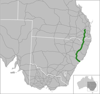
New England Highway is an 883-kilometre (549 mi) long highway in Australia running from Yarraman, north of Toowoomba, Queensland, at its northern end to Hexham at Newcastle, New South Wales, at its southern end. It is part of Australia's National Highway system, and forms part of the inland route between Brisbane and Sydney.

<span class="mw-page-title-main">Sturt Highway</span> Australian national highway

Sturt Highway is an Australian national highway in New South Wales, Victoria, and South Australia. It is an important road link for the transport of passengers and freight between Sydney and Adelaide and the regions along the route.

<span class="mw-page-title-main">Cobb Highway</span> Highway in New South Wales

Cobb Highway is a state highway in the western Riverina and the far western regions of New South Wales, with a short section in Victoria, Australia, designated part of route B75.

<span class="mw-page-title-main">Barton Highway</span> Highway in New South Wales and the Australian Capital Territory

Barton Highway is a highway in New South Wales and the Australian Capital Territory. It connects Canberra to Hume Highway at Yass, and it is part of the route from Melbourne to Canberra. It is named in honour of Sir Edmund Barton, the first Prime Minister of Australia.

<span class="mw-page-title-main">Monaro Highway</span> Highway in Australia

Monaro Highway is a 285-kilometre-long (177 mi) highway in Victoria, New South Wales, and the Australian Capital Territory, in Australia, linking Cann River in Victoria to Canberra in the Australian Capital Territory (ACT) via the Monaro region. From its southern terminus, it follows the nearby Cann River upstream towards the New South Wales border through heavily forested terrain. Within New South Wales (NSW), it makes its way through further forest before reaching the pastures typical of the Monaro. There are multiple towns and villages along the highway, including Bombala, Nimmitabel, and Cooma. The terrain within the Monaro is largely hilly, and there are numerous crossings. The road also parallels the former Bombala railway line in several locations. Within the ACT, the road becomes a high volume roadway and serves the southern suburbs of Canberra. The highway has more recently had a grade-separated dual carriageway extension constructed within Canberra, as part of the Eastern Parkway construction project. It is designated part of route M23, and route A23 within Canberra, and route B23 within Victoria and New South Wales, with a concurrency where it also carries route B72 between the two sections of Snowy Mountains Highway.

<span class="mw-page-title-main">Summerland Way</span>

Summerland Way is a 199–kilometre state route, designated B91, in New South Wales. It runs generally north from Grafton to the state border with Queensland just west of Mount Lindesay, and continues from there into Queensland as Mount Lindesay Highway. It was named as the region in runs through is a popular tourist area for people during summer.

<span class="mw-page-title-main">Kings Highway (Australia)</span> Highway in the Australian Capital Territory and New South Wales

Kings Highway is an interstate highway located within the Australian Capital Territory and New South Wales, Australia. The highway connects Canberra with Batemans Bay on the South Coast. It is designated route B52.

<span class="mw-page-title-main">Pennant Hills Road</span> Highway in Sydney, Australia

Pennant Hills Road is a 16.1-kilometre-long (10.0 mi) arterial road located in Sydney, New South Wales, Australia. The road links the suburb of Wahroonga in the northeast, to the major central business district of Parramatta in the southwest. Apart from a small section at its southwestern end, it is a constituent part of Cumberland Highway, and is designated part of route A28.

<span class="mw-page-title-main">Cahill Expressway</span> Highway in Sydney, Australia

Cahill Expressway is an urban freeway in Sydney and was the first freeway constructed in Australia, with the first section, from the Bradfield Highway to Conservatorium Place being opened to traffic in March 1958. It links the southern end of the Sydney Harbour Bridge, via an elevated roadway, a tunnel and cuttings between the Royal Botanic Garden and The Domain, to Woolloomooloo in Sydney's inner-eastern suburbs.

<span class="mw-page-title-main">Bylong Valley Way</span> Road in New South Wales, Australia

Bylong Valley Way is a New South Wales regional road linking Golden Highway near Sandy Hollow to Castlereagh Highway near Ilford. It is named after the Bylong Valley, through which the road passes.

Bathurst-Ilford Road is a 72.0-kilometre (44.7 mi) New South Wales country road linking Ilford to the regional hub of Bathurst.

O'Connell Road is a New South Wales rural road linking Oberon to the regional highway hub of Bathurst, where several roads including Great Western Highway, Mid-Western Highway, Mitchell Highway and Bathurst-Ilford Road join.

<span class="mw-page-title-main">Goulburn-Oberon Road</span>

Goulburn-Oberon Road is a New South Wales country road linking Goulburn near Hume Highway to Oberon. This name is not widely known to most drivers, as the entire allocation is still best known as by the names of its constituent parts: Taralga Road and Abercrombie Road.

<span class="mw-page-title-main">Wombeyan Caves Road</span>

Wombeyan Caves Road is a New South Wales country road linking Mittagong near Hume Highway in the east to Goulburn-Oberon Road at the locality of Richlands in the west.

<span class="mw-page-title-main">Lachlan Valley Way</span> Highway in New South Wales

Lachlan Valley Way is a New South Wales country road running from Booligal to north of Yass. It was named after the Lachlan River, and follows its southern bank for the majority of its length.

Camden Valley Way is a 23-kilometre (14 mi) arterial road between the southwestern fringes of suburban Sydney and the historic town of Camden. It is a former alignment of Hume Highway.

Remembrance Drive is a rural road that links Camden and Alpine on the fringes of south-western Sydney, New South Wales. The road served as the former alignment of Hume Highway and now forms part of Old Hume Highway.

References

  1. 1 2 "SIX maps". NSW Government . Retrieved 8 June 2013.
  2. 1 2 Google (3 August 2022). "Federal Highway" (Map). Google Maps . Google. Retrieved 3 August 2022.
  3. 1 2 "OPEN TO-DAY: Road to Canberra". Goulburn Evening Penny Post (DAILY and EVENING ed.). NSW. 25 February 1931. p. 3. Retrieved 8 June 2013 via National Library of Australia.
  4. 1 2 "Main Roads Act, 1924-1927". Government Gazette of the State of New South Wales. No. 110. National Library of Australia. 17 August 1928. pp. 3814–20. Retrieved 1 August 2022.
  5. State of New South Wales, An Act to provide for the better construction, maintenance, and financing of main roads; to provide for developmental roads; to constitute a Main Roads Board Archived 11 August 2022 at the Wayback Machine 10 November 1924
  6. State of New South Wales, An Act to amend the Main Roads Act, 1924-1927; to confer certain further powers upon the Main Roads Board; to amend the Local Government Act, 1919, and certain other Acts; to validate certain payments and other matters; and for purposes connected therewith. Archived 12 August 2022 at the Wayback Machine 8 April 1929
  7. "NEW HIGHWAY: open for traffic ON NSW SECTIONS". The Canberra Times . ACT. 6 December 1930. p. 1. Retrieved 20 December 2022.
  8. "ROAD NAMES: Sydney-Canberra Road NOW FEDERAL HIGHWAY". The Canberra Times . ACT. 28 September 1928. p. 1. Retrieved 20 December 2022.
  9. "NEW HIGHWAY: Collector to Canberra EARLY START THIS END". The Canberra Times . ACT. 5 April 1929. p. 1. Retrieved 20 December 2022.
  10. "NEW HIGHWAY: Canberra-Goulburn F.C.T. PORTION LET". The Canberra Times . ACT. 19 June 1929. p. 1. Retrieved 20 December 2022.
  11. "NEW HIGHWAY: nears completion IN THE TERRITORY". The Canberra Times . ACT. 13 February 1930. p. 1. Retrieved 20 December 2022.
  12. State of New South Wales, An Act to make provision with respect to the roads of New South Wales; to repeal the State Roads Act 1986, the Crown and Other Roads Act 1990 and certain other enactments; and for other purposes. Archived 11 August 2022 at the Wayback Machine 10 November 1924
  13. Transport for NSW (August 2022). "Schedule of Classified Roads and Unclassified Regional Roads" (PDF). Government of New South Wales. Archived from the original (PDF) on 25 August 2022. Retrieved 1 August 2022.
  14. 1 2 National Roads Act 1974 (Cth)
  15. "Ozroads: Federal Highway (ACT)" . Retrieved 9 June 2013.[ self-published source ]
  16. "Road number and name changes in NSW" (PDF). Roads & Maritime Services . Government of New South Wales. 2012. Archived from the original (PDF) on 25 March 2016. Retrieved 7 November 2016.
  17. "Guide Signs MIS 12" (PDF). ACT Government. April 2019. p. 13. Archived from the original (PDF) on 28 March 2020. Retrieved 9 November 2022.
  18. "ACTMAPi". ACT Government . Retrieved 12 August 2022.

Commons-logo.svg Media related to Federal Highway (Australia) at Wikimedia Commons

Template:Attached KML/Federal Highway (Australia)
KML is from Wikidata