The Molonglo River, a perennial river that is part of the Murrumbidgee catchment within the Murray–Darling basin, is located in the Monaro and Capital Country regions of New South Wales and the Australian Capital Territory, in Australia.

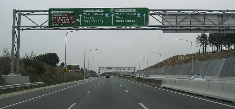
Monaro Highway is a 285-kilometre-long (177 mi) highway in Victoria, New South Wales, and the Australian Capital Territory, in Australia, linking Cann River in Victoria to Canberra in the Australian Capital Territory (ACT) via the Monaro region. From its southern terminus, it follows the nearby Cann River upstream towards the New South Wales border through heavily forested terrain. Within New South Wales (NSW), it makes its way through further forest before reaching the pastures typical of the Monaro. There are multiple towns and villages along the highway, including Bombala, Nimmitabel, and Cooma. The terrain within the Monaro is largely hilly, and there are numerous crossings. The road also parallels the former Bombala railway line in several locations. Within the ACT, the road becomes a high volume roadway and serves the southern suburbs of Canberra. The highway has more recently had a grade-separated dual carriageway extension constructed within Canberra, as part of the Eastern Parkway construction project. It is designated part of route M23, and route A23 within Canberra, and route B23 within Victoria and New South Wales, with a concurrency where it also carries route B72 between the two sections of Snowy Mountains Highway.

The District of Belconnen is one of the original eighteen districts of the Australian Capital Territory (ACT), used in land administration. The district is subdivided into 27 divisions (suburbs), sections and blocks. The district of Belconnen is largely composed of Canberra suburbs.

The District of Gungahlin is one of the original eighteen districts of the Australian Capital Territory used in land administration. The Gungahlin Region is one of fastest growing regions within Australia. The district is subdivided into divisions (suburbs), sections and blocks. Gungahlin is an Aboriginal word meaning either "white man's house" or "little rocky hill".
The District of Weston Creek is one of the original eighteen districts of the Australian Capital Territory used in land administration. The district is subdivided into divisions (suburbs), sections and blocks. The district of Weston Creek lies entirely within the bounds of the city of Canberra, the capital city of Australia. The district comprises eight residential suburbs, situated to the west of the Woden Valley district and approximately 13 kilometres (8.1 mi) southwest of the Canberra City centre. Situated adjacent to the district was the large Stromlo Forest pine plantation until the forest was destroyed by bushfires in 2001 and 2003.
Kambah is the northernmost suburb in the district of Tuggeranong, Canberra. It is located just south of Mount Taylor in the Canberra Nature Park. It is located north of the suburbs of Greenway and Wanniassa. It is bounded by Sulwood Drive to the north and Athllon Drive to the south-east.

Parkes Way is a major road in Canberra, Australia, which runs east-west between Kings Avenue and the Glenloch Interchange. At Glenloch Interchange it intersects with William Hovell Drive, Tuggeranong Parkway, and Caswell Drive. The road is freeway standard from the Commonwealth Avenue overpass to Glenloch Interchange. Parkes Way is named for prominent Australian federalist, Sir Henry Parkes.

The geology of the Australian Capital Territory includes rocks dating from the Ordovician around 480 million years ago, whilst most rocks are from the Silurian. During the Ordovician period the region—along with most of eastern Australia—was part of the ocean floor. The area contains the Pittman Formation consisting largely of Quartz-rich sandstone, siltstone and shale; the Adaminaby Beds and the Acton Shale.

Gungahlin Drive Extension (GDE) is a freeway grade road, located in the Belconnen district of Canberra, Australia. It is 8.3 kilometres long and extended the previously existing Gungahlin Drive from the Barton Highway in the district of Gungahlin to the Glenloch Interchange to connect with the Tuggeranong Parkway, Parkes Way, and William Hovell Drive. Early in the planning stages, the GDE was to instead be designated the John Dedman Parkway.

From 2016, the 25-member unicameral Australian Capital Territory Legislative Assembly is elected from five multi-member electorates, with five seats per electorate.

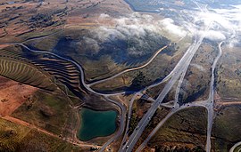
Glenloch Interchange is Canberra's only major interchange which connects Tuggeranong Parkway with Parkes Way, William Hovell Drive and Caswell Drive. Following a major reconstruction lasting from 2007 to mid-2008, the interchange now operates without traffic lights. A surprising feature was the retention of an unused bridge from the previous alignment which led from the centre of the Parkes Way/Caswell Drive loop, passing east over two northbound roads, before petering out to the east. This was finally removed in late 2010 during roadworks to upgrade the new interchange to dual carriageway standards.
Majura Parkway is a 11.5-kilometre-long (7.1 mi) north–south parkway located in the Majura district of the Australian Capital Territory (ACT). It links the interchange with Federal Highway and Horse Park Drive at the edge of Gungahlin district to Monaro Highway in Fyshwick.

Ginninderra Drive is a major arterial road in the northern suburbs of Canberra, the capital city of Australia. The road provides an important access corridor to facilities including the Australian Institute of Sport, Canberra Stadium, the University of Canberra and Belconnen Town Centre. It is built to a dual carriageway standard carrying two or three traffic lanes in each direction for most of its length, with a speed limit of 80 km/h (50 mph). A short section from Charnwood to Dunlop is single carriageway with a speed limit of 60 km/h (37 mph). The first section of the road, connecting Lyneham with the new suburb of Evatt opened to traffic in October 1976.

Hindmarsh Drive is a major arterial road in the southern suburbs of Canberra, the capital city of Australia. It is named after John Hindmarsh, first Governor of South Australia. The road forms the major east to west link through the Woden Valley and Weston Creek districts, and is an important access corridor for both Canberra Hospital and the Woden Town Centre. Hindmarsh Drive is intersected by both the Monaro Highway and Tuggeranong Parkway at grade separated intersections. In 2010, the ACT Government announced that Hindmarsh Drive would be the site of the first point-to-point average speed cameras to be installed in the Territory. The cameras became operational on 27 February 2012.
Drakeford Drive is an arterial road in the Tuggeranong district of the Australian Capital Territory, a southern suburb of the nation's capital Canberra. The road is named for Arthur Drakeford, Federal Minister for Air and Civil Aviation from 1941 to 1949. The route extends as a divided dual carriageway from the southern end of the Tuggeranong Parkway at Kambah, passing east of Lake Tuggeranong and continues to the suburb of Calwell where it joins Tharwa Drive. The speed limit on Drakeford Drive is 80 km/h (50 mph). In 2012, a large sculpture by artist Alexander Knox, entitled Moth Ascending the Capital was erected on the median strip in Kambah, drawing local criticism about its necessity. In September 2012, a pedestrian overpass over Drakeford Drive was completed, allowing a safer and more convenient crossing for students from Namadgi School in Kambah.
Tharwa Drive is an arterial road, in the southern Australian Capital Territory. The road extends from the Monaro Highway through the Tuggeranong district in Canberra's southern suburbs, connecting with Drakeford Drive before continuing south through the Lanyon Valley and crossing the Murrumbidgee River at the village of Tharwa. Tharwa Drive provides access to the historic Lanyon Homestead, the Murrumbidgee Corridor nature reserve. Restoration of the heritage listed Tharwa Bridge, which carries the road over the Murrumbidgee was completed in 2011, following several years of closures and traffic restrictions.

Yarra Glen is a major grade separated arterial road in Canberra. It is 3 km (1.9 mi) in length connects South Canberra to the Woden Valley district. It links at its northern end to Adelaide Avenue, and at its southern end to Melrose Drive and Yamba Drive via a large roundabout. It was designed to have no traffic lights nor cross roads on it.
Gungahlin Drive is an arterial road in Canberra, Australia. Its urban portion is 7.4 km (5 mi) long, and serves as one of the major thoroughfares in the Gungahlin district, before becoming a parkway standard roadway south of the Barton Highway. This high quality section was built as the major part of the Gungahlin Drive Extension project.

The 2024 Australian Capital Territory general election will be held on or before Saturday the 19th of October 2024 to elect all 25 members of the unicameral ACT Legislative Assembly.