
The Barton Highway is a short highway in New South Wales and the Australian Capital Territory, Australia.

The Monaro Highway is a highway in Victoria, New South Wales, and the Australian Capital Territory, in Australia.

The District of Belconnen is one of the original eighteen districts of the Australian Capital Territory (ACT), used in land administration. The district is subdivided into 27 divisions (suburbs), sections and blocks. The district of Belconnen is largely composed of Canberra suburbs.

The District of Gungahlin is one of the original eighteen districts of the Australian Capital Territory used in land administration. Gungahlin Region is one of fastest growing regions within Australia. The district is subdivided into divisions (suburbs), sections and blocks. Gungahlin is an Aboriginal word meaning either "white man's house" or "little rocky hill".

Macquarie is a residential suburb in the Belconnen district of Canberra, located within the Australian Capital Territory, Australia. Macquarie was gazetted as a division on 22 June 1967 in recognition of Major-General Lachlan Macquarie, a former Governor of New South Wales. Streets in Macquarie are named after contemporaries of Governor Macquarie.
Aranda is a suburb in the district of Belconnen, in the Australian capital city of Canberra. Located at the western foot of Black Mountain and bounded on two sides by nature park, the suburb is characterised by its bush setting. During the planning and development of the suburb, a large proportion of large native trees – predominantly eucalypts – were left in place.

Northbourne Avenue is a major road in Canberra, Australia. It extends from City Hill in the south to the Federal Highway in the north.
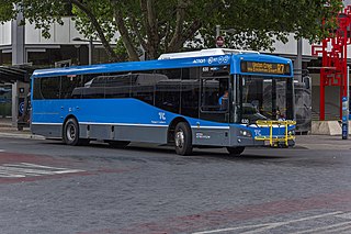
ACTION is a bus operator in Canberra, Australia owned by the ACT Government.

Belconnen is the most inner suburb of the larger district of Belconnen in Canberra, Australia. Sharing its name with the larger district which encapsulates it, the suburb is surrounded with well developed infrastructure, and planning which allows it sunset views from the Brindabellas on its western side. The suburb contains important amenities for the District of Belconnen including the Belconnen Town Centre and Lake Ginninderra as well as its own well populated residential areas. It is bounded by Ginninderra Drive, Aikman Drive, Eastern Valley Way, Belconnen Way and Coulter Drive. It has a number of parks such as Margaret Timpson Park, Eastern Valley Oval, and on the foreshores of Lake Ginninberra, Diddams Close Park and John Knight Memorial Park.

Parkes Way is a major road in Canberra, Australia, which runs east–west between Kings Avenue and the Glenloch Interchange. At Glenloch Interchange it intersects with William Hovell Drive, Tuggeranong Parkway and Caswell Drive. The road is freeway standard from the Commonwealth Avenue overpass to Glenloch Interchange. Parkes Way is named for prominent Australian federalist, Sir Henry Parkes.

Tuggeranong Parkway is an 11-kilometre-long (6.8 mi) major highway in Canberra, Australia. Often referred to as "The Parkway" by locals, Tuggeranong Parkway links Civic to the southern Canberra metro district of Tuggeranong, and is a bypass road to the Woden Valley-Weston Creek district of Canberra. It also links to the Glenloch Interchange, where roads such as Caswell Drive connect to Belconnen.

Kingsford Smith Drive, is a main road in the district of Belconnen in Canberra, Australia and is named in honour of Sir Charles Kingsford Smith.

Gungahlin Drive Extension is a freeway grade road, located in the Belconnen district of Canberra, Australia. It is 8.3 kilometres long and extended the previously existing Gungahlin Drive from the Barton Highway in the district of Gungahlin to the Glenloch Interchange to connect with the Tuggeranong Parkway, Parkes Way, and William Hovell Drive. Early in the planning stages, the GDE was to instead be designated the John Dedman Parkway.
Southern Cross Drive, Canberra is a dual carriageway road in the district of Belconnen, Australian Capital Territory. It bypasses the suburbs of Page, Florey, Latham, Scullin, Higgins, Holt and Macgregor. Southern Cross Drive becomes Parkwood Road west of Macgregor. Parkwood Road is the main thoroughfare to Parkwood Landfill and Ginninderra Falls. The general speed limit is 60 km/h, with an 80 km/h limit between Kingsford Smith Drive and Coulter Drive

Belconnen Way is a major road in Canberra, Australia. It connects William Hovell Drive and Kingsford Smith Drive in the west to Barry Drive and Fairfax Street, providing access to Civic and the Inner North via Belconnen Town Centre. In addition to being used as an alternate route to the city by commuters from the northern suburbs, it provides the primary connection to the Belconnen Town Center. Along with Barry Drive, Belconnen Way was constructed in stages between 1965 and 1971 as a single carriageway road. It was progressively duplicated as the district's traffic and population grew. A connection to Gungahlin Drive forms the largest signalized and overpass intersection in Canberra, constructed during the Gungahlin Drive Extension works and opening in 2011.
Majura Road is a major arterial road in the eastern rural area of Canberra, the capital city of Australia. The road runs north to south, beginning at a grade separated junction with the Federal Highway 1 km (0.62 mi) inside the border of the Australian Capital Territory. The route followed by the road passes to the east of Mount Majura and mostly rural and industrial properties including the Majura Military Training Area, Mount Majura Winery and a training facility for the Australian Federal Police towards the Majura Park development at Canberra Airport where it ends at Fairbairn Avenue. The road provides a convenient bypass of the city's Inner North from the Gungahlin district to Queanbeyan. Canberra Airport and the Monaro Highway. The route is signposted as an alternative to National Highway 23, the main route between Sydney and the Snowy Mountains and carries considerable volumes of heavy vehicle and tourist traffic.

Ginninderra Drive is a major arterial road in the northern suburbs of Canberra, the capital city of Australia. The road provides an important access corridor to facilities including the Australian Institute of Sport, Canberra Stadium, the University of Canberra and Belconnen Town Centre. It is built to a dual carriageway standard carrying two or three traffic lanes in each direction for most of its length, with a speed limit of 80 km/h (50 mph). A short section from Charnwood to Dunlop is single carriageway with a speed limit of 60 km/h (37 mph). The first section of the road, connecting Lyneham with the new suburb of Evatt opened to traffic in October 1976.

Hindmarsh Drive is a major arterial road in the southern suburbs of Canberra, the capital city of Australia. It is named after John Hindmarsh, first Governor of South Australia. The road forms the major east to west link through the Woden Valley and Weston Creek districts, and is an important access corridor for both Canberra Hospital and the Woden Town Centre. Hindmarsh Drive is intersected by both the Monaro Highway and Tuggeranong Parkway at grade separated intersections. In 2010, the ACT Government announced that Hindmarsh Drive would be the site of the first point-to-point average speed cameras to be installed in the Territory. The cameras became operational on 27 February 2012.

Yarra Glen is a major grade separated arterial road in Canberra. It is 3 km (1.9 mi) in length connects South Canberra to the Woden Valley district. It links at its northern end to Adelaide Avenue, and at its southern end to Melrose Drive and Yamba Drive via a large roundabout. It was designed to have no traffic lights nor cross roads on it.
Gungahlin Drive is an arterial road in Canberra, Australia. Its urban portion is 7.4 km (5 mi) long, and serves as one of the major thoroughfares in the Gungahlin district, before becoming a parkway standard roadway south of the Barton Highway, this high quality section was built as the major part of the Gungahlin Drive Extension project.