Dingo Creek

Last updated

Dingo Creek
Eastern Branch Dingo Creek
Australia New South Wales relief location map.png
Red pog.svg
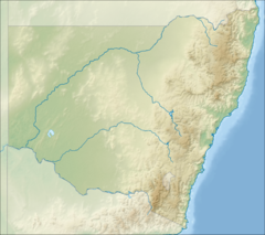
Location of mouth in NSW
EtymologyDerived from the Aboriginal Kattang word tapin, meaning dingo [1]
Location
Country Australia
State New South Wales
Region NSW North Coast (IBRA), Mid North Coast
Municipality Greater Taree
Physical characteristics
SourceMount Gibraltar, Comboyne Plateau
  locationnorth of Wingham
  elevation693 m (2,274 ft)
Mouth confluence with the Manning River
  location
at Kilawarra, west of Wingham
  elevation
14 m (46 ft)
Length78 km (48 mi)
Basin features
River system Manning River catchment
Tributaries 
  right Bobin Creek, Caparra Creek
[2] [3]

Dingo Creek, a perennial stream of the Manning River catchment, is located in the Mid North Coast region of New South Wales, Australia.

Contents

Course and features

The Dingo Creek rises below the Comboyne Plateau, about 1.6 kilometres (0.99 mi) southwest of Mount Gibraltar within the Killabakh Nature Reserve, north of the town of Wingham. The river flows generally west to a point east of Tapin Tops National Park, then south, joined by the Bobin and Caparra creeks, before reaching its confluence with the Manning River, at Kilawarra, west of Wingham. The river descends 679 metres (2,228 ft) over its 78 kilometres (48 mi) course. [3]

The Manning River eventually flows into the Tasman Sea through a minor delta east of Taree. [2]

Etymology

The traditional custodians of the land surrounding the Dingo Creek are the Australian Aboriginal Biripi people [4] . The name of the creek is derived from the Aboriginal Gathang word tapin, meaning dingo, [1] a subspecies of the grey wolf.

See also

Related Research Articles

<span class="mw-page-title-main">Tapin Tops National Park</span> Protected area in New South Wales, Australia

Tapin Tops National Park is a 110 km2 (42 sq mi) national park that is located in the Mid North Coast region of New South Wales, Australia.

<span class="mw-page-title-main">Taree</span> City in New South Wales, Australia

Taree is a city on the Mid North Coast, New South Wales, Australia. It and nearby Cundletown were settled in 1831 by William Wynter. Since then it has grown to a population of 26,381, and commands a significant agricultural district. Situated on a floodplain by the Manning River, it is 16 km from the Tasman Sea coast, and 317 km north of Sydney.

<span class="mw-page-title-main">Wingham, New South Wales</span> Town in New South Wales, Australia

Wingham is a town in the Mid North Coast region of New South Wales, Australia in the Mid-Coast Council area 329 kilometres (204 mi) north of Sydney. According to the 2021 census, Wingham had a population of 5,395.

Tinonee is a small town on the banks of the Manning River, near Taree on the Mid North Coast of New South Wales in Mid-Coast Council, Australia. Tinonee was founded in 1854 and in the late 1980s became part of Greater Taree City. At the 2006 census, Tinonee had a population of 734 people.

<span class="mw-page-title-main">Manning River</span> River in New South Wales, Australia

Manning River, an open and trained mature wave dominated barrier estuary, is located in the Northern Tablelands and Mid North Coast districts of New South Wales, Australia. It is the only double delta river in the southern hemisphere in which there are two permanent entrances to the river, one at Old Bar and another at Harrington, and is famously one of only two rivers in the world to have permanent multiple entrances with the other being the Nile river in Egypt.

<span class="mw-page-title-main">Avon River (Mid-Coast Council)</span> River in the Upper Hunter region of New South Wales, Australia

Avon River, a perennial stream of the Manning River catchment, is located in the Upper Hunter region of New South Wales, Australia.

Cells River, a perennial river of the Manning River catchment, is located in the Northern Tablelands and Mid North Coast districts of New South Wales, Australia.

Dyke River is a perennial stream of the Macleay River catchment, located in the Northern Tablelands district of New South Wales, Australia.

<span class="mw-page-title-main">Gloucester River</span> River in New South Wales, Australia

Gloucester River, a perennial river and major tributary of the Manning River catchment, is located in the Mid North Coast hinterland New South Wales, Australia.

<span class="mw-page-title-main">Nowendoc River</span> River in Australia

Nowendoc River, a perennial river of the Manning River catchment, is located in the Northern Tablelands and Mid North Coast districts of New South Wales, Australia.

<span class="mw-page-title-main">Forbes River (New South Wales)</span> River in New South Wales, Australia

Forbes River, a perennial river of the Hastings River catchment, is located in the Mid North Coast region of New South Wales, Australia.

Araluen Creek, a partly perennial stream of the Moruya River catchment, is located in the Southern Tablelands and South Coast regions of New South Wales, Australia.

The Georges Creek, a perennial stream that is part of the Macleay River catchment, is located in the Northern Tablelands and Mid North Coast regions of New South Wales, Australia.

Caparra Creek, a perennial stream of the Manning River catchment, is located in the Mid North Coast region of New South Wales, Australia.

Bobin Creek is a non–perennial stream of the Manning River catchment in the Mid North Coast region of New South Wales, Australia.

Connollys Creek, a watercourse of the Manning River catchment, is located in the Mid North Coast region of New South Wales, Australia.

Cedar Party Creek, a perennial stream of the Manning River catchment, is located in the Mid North Coast region of New South Wales, Australia.

Burns Creek, a watercourse of the Manning River catchment, is located in the Northern Tablelands region of New South Wales, Australia.

<span class="mw-page-title-main">MidCoast Council</span> Local government area in New South Wales, Australia

MidCoast Council is a local government area that is located in the Mid North Coast region of New South Wales, Australia. The council was formed on 12 May 2016 through a merger of the Gloucester Shire, Great Lakes and City of Greater Taree Councils.

<span class="mw-page-title-main">Wingham Memorial Town Hall</span> Historic site in New South Wales, Australia

Wingham Memorial Town Hall is a heritage-listed town hall at 52 Farquhar Street, Wingham, Mid-Coast Council, New South Wales, Australia. It was designed by James T. Chambers and built from 1922 to 1924. It is also known as Wingham Town Hall and Wingham Council Chambers. The property is owned by Mid-Coast Council. It was added to the New South Wales State Heritage Register on 8 April 2016.

References

  1. 1 2 "Tapin Tops National Park (NSW)". Kevin's Wilderness Journeys. Kevin Matthews. 27 November 2010. Retrieved 15 October 2013.
  2. 1 2 "Dingo Creek". Geographical Names Register (GNR) of NSW. Geographical Names Board of New South Wales . Retrieved 14 October 2013. OOjs UI icon edit-ltr-progressive.svg
  3. 1 2 "Map of Dingo Creek, NSW". Bonzle Digital Atlas of Australia. Retrieved 14 October 2013.
  4. Klaver, J; Kefferman, K. J. "Aboriginal Culture and history in the Manning Valley" (PDF). Greater Taree Aboriginal Heritage Study. Manning Valley Tourism. p. 1. Retrieved 16 March 2013.[ permanent dead link ]

31°40′S152°19′E / 31.667°S 152.317°E / -31.667; 152.317