Oaky River | |
---|---|
Location | |
Country | Australia |
State | New South Wales |
IBRA | New England Tablelands |
District | Northern Tablelands |
local government area | Armidale Dumaresq |
Physical characteristics | |
Source | Round Mountain, Sonwy Range, Great Dividing Range |
• location | below Point Lookout, near Ebor |
• elevation | 1,400 m (4,600 ft) |
Mouth | confluence with the Chandler River |
• location | near Jeogla |
• elevation | 277 m (909 ft) |
Length | 60 km (37 mi) |
Basin features | |
River system | Macleay River catchment |
Tributaries | |
• right | Ponds Creek |
National park | Cathedral Rock NP, New England NP |
[1] |
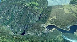
Oaky River, a perennial stream of the Macleay River catchment, is located in the Northern Tablelands district of New South Wales, Australia.
Oaky River rises on the southern slopes of Round Mountain, the highest peak of the Snowy Range, a spur of the Great Dividing Range south southwest of Ebor, and flows generally southwest, joined by one minor tributary before reaching its confluence with the Chandler River, southwest of Jeogla. The river descends 881 metres (2,890 ft) over its 51 kilometres (32 mi) course; [1] rapidly descending into a deep gorge where it meets the Chandler River.
The upper reaches of Oaky River are transversed by the Waterfall Way between Wollomombi and Ebor.
Oaky River and its tributaries are trout streams and platypus may be sighted in the waters. [2] [3]
The river is impounded by Oaky River Dam, located approximately 40 kilometres (25 mi) from Armidale. At capacity, the dam covers around 42 hectares (100 acres) and holds 2,780 megalitres (98×10 6 cu ft) of water. A hydroelectric power station is located at the dam and the flow of water is used to generate electricity. The power station has five turbines that generate 12 megawatts (16,000 hp).[ citation needed ] Zihni Buzo, an Albanian migrant and Harvard-educated civil engineer was the leading engineer on the construction of the dam and hydroelectric scheme. [4] [5] [6] This dam burst in February 2013 and is no longer viable. [7]
The Macleay River is a river that spans the Northern Tablelands and Mid North Coast districts of New South Wales, Australia.
Jindabyne Dam is a major ungated rockfill embankment dam across the Snowy River in the Snowy Mountains of New South Wales, Australia. The dam's main purpose is for the generation of hydro-power and is one of the sixteen major dams that comprise the Snowy Mountains Scheme, a vast hydroelectricity and irrigation complex constructed in south-east Australia between 1949 and 1974 and now run by Snowy Hydro.
Tooma Dam is a major ungated concrete embankment dam across the Tooma River in the Snowy Mountains of New South Wales, Australia. The dam's main purpose is for the generation of hydro-power and is one of the sixteen major dams that comprise the Snowy Mountains Scheme, a vast hydroelectricity and irrigation complex constructed in south-east Australia between 1949 and 1974 and now run by Snowy Hydro.
Round Mountain, a mountain of the Snowy Range, a spur of the Great Dividing Range, is located on the Northern Tablelands in the New England region in New South Wales, Australia.
Styx River, a perennial stream of the Macleay River catchment, is located in the Northern Tablelands district of New South Wales, Australia.
Guy Fawkes River, a perennial stream that is part of the Clarence River catchment, is in the New England and Northern Tablelands districts of New South Wales, Australia.
The Bemboka River, a perennial stream of the Bega River catchment, is located in the Monaro and South Coast regions of New South Wales, Australia.
Dyke River is a perennial stream of the Macleay River catchment, located in the Northern Tablelands district of New South Wales, Australia.
Gara River, a perennial river that is a tributary of the Macleay River, is located in the Northern Tablelands region of New South Wales, Australia.
Tia River, a perennial stream of the Macleay River catchment, is located in the Northern Tablelands district of New South Wales, Australia.
Wollomombi River, a perennial stream of the Macleay River catchment, is located in the Northern Tablelands district of New South Wales, Australia.
The Yarrangobilly River is a perennial river of the Murrumbidgee River catchment within the Murray–Darling basin, located in the Snowy Mountains region of New South Wales, Australia.
Yarrowitch River, a perennial stream of the Macleay River catchment, is located in the Northern Tablelands district of New South Wales, Australia.
Swampy Plain River, a perennial stream that is part of the Murray catchment within the Murray–Darling basin, is located in the Snowy Mountains bioregion of New South Wales, Australia.
Chandler River, a perennial stream of the Macleay River catchment, is located in the Northern Tablelands district of New South Wales, Australia.
The Georges Creek, a perennial stream that is part of the Macleay River catchment, is located in the Northern Tablelands and Mid North Coast regions of New South Wales, Australia.
The Blue Mountain Creek, an intermittent stream that is part of the Macleay River catchment, is located in the Northern Tablelands region of New South Wales, Australia.
The Kunderang Brook, a perennial stream that is part of the Macleay River catchment, is located in the Northern Tablelands and Mid North Coast regions of New South Wales, Australia.
The Christmas Creek, a perennial stream that is part of the Macleay River catchment, is located in the Mid North Coast region of New South Wales, Australia.
Zihni Jusuf Buzo (1912-2006) was an Albanian Australian civil engineer.
{{cite web}}
: CS1 maint: archived copy as title (link)