Inverell is a large town in northern New South Wales, Australia, situated on the Macintyre River, close to the Queensland border. It is also the centre of Inverell Shire. Inverell is located on the Gwydir Highway on the western slopes of the Northern Tablelands. It has a temperate climate. In the 2016 census, the population of Inverell was 11,660 and the Inverell Shire population was 16,483.

Tocumwal is a town in the southern Riverina region of New South Wales, Australia, in the Berrigan Shire local government area, near the Victorian border. The town is situated on the banks of the Murray River, 270 kilometres (170 mi) north of the city of Melbourne. The Newell Highway and Murray Valley Highway join at the Murray River, and form part of the main road route National Highway A39 between Brisbane and Melbourne. At the 2006 census, Tocumwal had a population of 1,860.

Turramurra is a suburb on the Upper North Shore of Sydney, in the state of New South Wales, Australia. It is located 17 kilometres (11 mi) north-west of the Sydney central business district, in the local government area of Ku-ring-gai Council. It shares the postcode of 2074 with the adjacent suburbs of North Turramurra, South Turramurra and Warrawee.

Junee is a medium-sized town in the Riverina region of New South Wales, Australia. The town's prosperity and mixed services economy is based on a combination of agriculture, rail transport, light industry and government services, and in particular correctional services. In 2015 Junee's urban population was 4,762.

Huskisson is a town in New South Wales, Australia in the City of Shoalhaven, on the shores of Jervis Bay. It is 24 km south-east of Nowra.

Mount Victoria is a small township in the Blue Mountains of New South Wales, Australia. It is the westernmost village in the City of Blue Mountains, located about 120 kilometres (75 mi) by road from the Sydney central business district and at an altitude of about 1,052 metres (3,451 ft) AHD . The settlement had a population of 823 people at the 2011 Census.

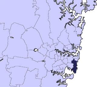
The City of Randwick is a local government area in the eastern suburbs of Sydney, New South Wales, Australia. Established in 1859, Randwick is the second-oldest local government area in New South Wales, after the City of Sydney. It comprises an area of 36 square kilometres (14 sq mi) and as at the 2016 census had a population of 140,660.

Ben Lomond is a village on the Northern Tablelands in the New England region of New South Wales, Australia. The village is situated 6 km off the New England Highway between Armidale and Glen Innes. It was located in the Guyra Shire local government area until that council was amalgamated into the Armidale Regional Council on 12 May 2016, with parts of the surrounding district in Glen Innes Severn Shire and Inverell Shire. It is primarily a farming area, with most of the residents involved in sheep, cattle and grain farming.

Carrathool is a village in the western Riverina region of New South Wales, Australia, in Carrathool Shire. In 2011 census, Carrathool had a population of 296 people. It is about 5 kilometres (3 mi) north of the Sturt Highway between Darlington Point and Hay. The village is situated on the plain a few kilometres north of the river, clustered around the now-disused railway station.

Rosewood is a village community and locality in the south east part of the Riverina, New South Wales, Australia. It is situated about 16 kilometres (9.9 mi) south east from Carabost and 19 kilometres (12 mi) north west from Tumbarumba. At the 2016 census, Rosewood had a population of 214. The village is administered by two local governments; the northern part of the locality by the Greater Hume Shire and the southern part of the locality by the Snowy Valleys Council. The village of Rosewood is within the Snowy Valleys Council area.

Bungonia is a small town in the Southern Tablelands in New South Wales, Australia in Goulburn Mulwaree. At the 2016 census, Bungonia had a population of 367. The name of the town derives from an Aboriginal word meaning 'sandy creek'.

Ardglen is a village on the Main North railway line and close to the New England Highway on the North West Slopes region of New South Wales, Australia.

Lilyvale is a locality most of whose area is within the Royal National Park, south of Sydney, Australia. Helensburgh railway station was within the southern populated part of the locality. A Lilyvale railway station was open from 1890 until 1983.

Murrumbidgee Council is a local government area in the Riverina region of New South Wales, Australia. This area was formed in 2016 from the merger of the Murrumbidgee Shire with the neighbouring Jerilderie Shire.

Castle Doyle is a locality in the Armidale Regional Council region of New South Wales, Australia. It is bounded by Commissioners Waters to the north and the Gara River to the east. It had a population of 164 as of the 2016 census.

Wisemans Creek is a locality in the Oberon Shire of New South Wales, Australia. The area has also been known as Glenburn. It had a population of 113 people as of the 2016 census.

Raglan is a locality in the Bathurst Region of New South Wales, Australia. It was named after FitzRoy Somerset, 1st Baron Raglan, commander-in-chief of the Allied forces in the Crimean War from 1850 to 1855. It had a population of 1,199 people as of the 2016 census.

Tanja is a locality in the Bega Valley Shire of New South Wales, Australia. At the 2016 census, Tanja had a population of 157.

Windeyer is a locality in the Mid-Western Regional Council of New South Wales, Australia. It had a population of 176 as of the 2016 census.


