
Tamworth is a city and administrative centre of the north-eastern region of New South Wales, Australia. Situated on the Peel River within the local government area of the Tamworth Regional Council, it is the largest and most populated city in the region, with a population of 43,874 in 2021, making it the second largest inland city in New South Wales. Tamworth is 318 km (198 mi) from the Queensland border and is located almost midway between Brisbane and Sydney.

New England is a geographical region in the north of the state of New South Wales, Australia, about 60 km inland from the Tasman Sea. The area includes the Northern Tablelands and the North West Slopes regions. As of 2021, New England had a population of 185,560, with over a quarter of the people living in the area of Tamworth Regional Council.

Lindfield is a suburb on the Upper North Shore of Sydney in the state of New South Wales, Australia. It is 13 kilometres north-west of the Sydney Central Business District and is in the local government area of Ku-ring-gai Council. East Lindfield is a separate suburb to the east, sharing the postcode of 2070.
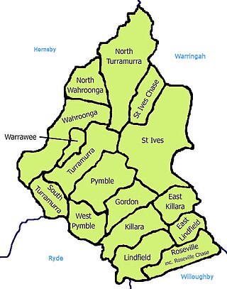
St Ives is a suburb on the Upper North Shore of Sydney in the state of New South Wales, Australia 18 kilometres north of the Sydney Central Business District in the local government area of Ku-ring-gai Council. St Ives Chase is a separate adjacent area, designated suburb, to the west and north.

Branxton is a town in the Hunter Region of New South Wales, Australia. Branxton is 171 kilometres (106 mi) north of Sydney via the Sydney–Newcastle Freeway and New England Highway. Branxton is located mostly in the City of Cessnock, but part of it is in Singleton Shire.

Quirindi is a small town on the North West Slopes region of New South Wales, Australia, in Liverpool Plains Shire. At the 2021 census, Quirindi had a population of 2,602. It is the nearest link to Gunnedah to the northwest and Tamworth to the north. The local economy is based on agriculture, with broadacre farming dominant on the black soil plains to the west and livestock grazing in the hilly eastern part of the district.
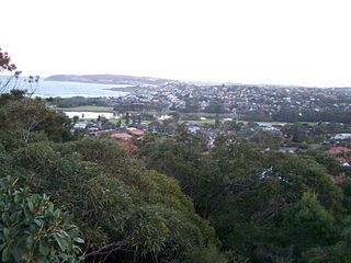
North Curl Curl is a suburb in northern Sydney, in the state of New South Wales, Australia 19 kilometres north-east of the Sydney central business district, in the local government area of Northern Beaches Council. It is part of the Northern Beaches region.
Kootingal is a town in New South Wales, Australia in the Tamworth Regional Council area. It is commonly called a satellite suburb of Tamworth because of its closeness and the fact that its residents use Tamworth's services. Founded as an Aboriginal mission, Kootingal traces its name roots to the local Aboriginal Kamilaroi language. At the 2021 census, Kootingal had a population of 2,313 people.
The Moonbi Range, a mountain range that is part of the Great Dividing Range, is located in the Northern Tablelands of New South Wales, Australia.
Tintinhull is a tiny hamlet about 10 kilometres east of Tamworth, New South Wales, Australia. It is situated between Nemingha and Kootingal, and lies on the New England Highway. The locality is 466 km from Sydney, on the Main North Rail Line which opened in 1885 and closed in December 1971.
Lochinvar is a village in the Hunter Region of New South Wales, Australia, eleven kilometres west of the regional centre of Maitland. Lochinvar is within the boundaries of the City of Maitland local government area and is named after Lochinvar, a loch in southern Scotland.
East Gresford is a village in the Hunter Region of New South Wales, Australia in Dungog Shire. The village is located 192 kilometres (119 mi) north of Sydney and the nearest major centres are Singleton some 42 kilometres (26 mi) southwest and Maitland to the south. In the 2006 census, it had a population of 289.
Group 4 is a rugby league competition in the New England and north west area of New South Wales, run under the auspices of the Country Rugby League.

Tamworth Regional Council is a local government area in the New England region of New South Wales, Australia. The area under administration is located adjacent to the New England Highway and the Main North railway line. It was established in March 2004 through the amalgamation of the former City of Tamworth with surrounding shires of Barraba, Manilla, Nundle and Parry.
An outbreak of equine influenza (EI) in Australia was confirmed by the Department of Primary Industries on 24 August 2007 in Sydney. Also known as "horse flu" and "A1 influenza", the rapid outbreak was of the Influenza A virus strain of subtype H3N8. While the virus is highly contagious, it rarely kills adult horses but the performance of thoroughbred racing horses can be affected for several weeks. It can be fatal to young foals and debilitated horses.

Bendemeer is a village of 485 people on the Macdonald River in the New England region of New South Wales, Australia. It is situated at the junction of the New England and Oxley Highways.

Niangala is a village located on the south-eastern edge of the Northern Tablelands area of New South Wales, Australia. It is on the Moonbi Range which is part of the Great Dividing Range, at approximately 1,300 metres (4,265 ft) above sea level. The village is in Walcha parish in Parry County. At the 2011 census, Niangala and the surrounding area had a population of 142.
Danglemah is a bounded rural locality in the New England region of Australia.
Duri is a village south of Tamworth in the New England region of New South Wales, Australia. It lies on the Werris Creek Road and the Main North railway line. At the 2011 census, Duri had a population of 534.
Moonbi House is a heritage-listed colonial pastoral station and now retirement village located on the New England Highway in Kootingal in the Tamworth Regional Council local government area of New South Wales, Australia. The house was built from 1895 to 1896. It is also known as Moonbi Retirement Homes. The property is owned by the Freemasons Institution of NSW and was added to the New South Wales State Heritage Register on 2 April 1999.


