
Tamworth is a city and the administrative centre of the North Western region of New South Wales, Australia. Situated on the Peel River within the local government area of Tamworth Regional Council, it is the largest and most populated city in the North Western region, with a population of 42,872 in June 2018, making it the second largest inland city in New South Wales. Tamworth is 318 km (198 mi) from the Queensland border, and it is located almost midway between Brisbane and Sydney.
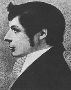
John Joseph William Molesworth Oxley was an explorer and surveyor of Australia in the early period of British colonisation. He served as Surveyor General of New South Wales and is perhaps best known for his two expeditions into the interior of New South Wales and his exploration of the Tweed River and the Brisbane River in what is now the state of Queensland.

Manilla is a small town in New South Wales, Australia, located on Fossickers Way 45 kilometres northwest of the regional city of Tamworth and 27 kilometres northeast of the historic village Somerton. At the 2006 census, Manilla had a population of 2,550 people. Manilla is famous for its setting as a fishing and paragliding area and soon to be the destination for ABCs Triple J "one night stand" music festival. The name Manilla comes from the Gamilaraay language, and is said to mean 'winding river'.

St. Matthew's Anglican Church is an Anglican church in the Glebe neighbourhood of Ottawa, Ontario, Canada. Founded in 1898 to serve the growing area it is the fifth oldest Anglican parish in central Ottawa after St. Alban's, St. Bartholomew's, Trinity, and Ascension. It is a registered charity # 108084658RR0078 providing spiritual worship, spiritual guidance, pastoral care, and community outreach.

Upper Hunter is an electoral district of the Legislative Assembly in the Australian state of New South Wales. It is represented by Michael Johnsen of the Nationals.

Tamworth is an electoral district of the Legislative Assembly in the Australian state of New South Wales. It is represented by Kevin Anderson of the National Party. Tamworth was held by independent member Tony Windsor between 1991 and 2001 when he was elected to the Australian House of Representatives as the Member for New England.

All Saints Anglican Church is an Anglican church in the Diocese of Sydney. The church is located at 325 Stanmore Road, Petersham, New South Wales, Australia.
Oxley Vale is a suburb of Tamworth, New South Wales, Australia, which runs either side of Manilla road. It is between the suburbs of North Tamworth and the satellite suburb of Hallsville. Oxley Vale is a largely residential suburb. Nazareth House nursing house is located there.
St. Stephen's Anglican Church is an Anglican Church of Canada parish in Ottawa, Ontario, Canada.

Somerton is a village between Tamworth and Gunnedah on the Oxley Highway in northern New South Wales Australia. In the 2016 census, there were 277 people in Somerton. Somerton Village adjoins the plentiful Peel River.

HMS Sealark was a Royal Navy vessel used primarily for hydrographic survey work. She was originally a luxurious private auxiliary steam yacht for a number of wealthy owners and in 1903 was acquired by the Royal Navy, serving until 1914. She was sold to James Patrick Steamships Ltd and converted to a merchant ship for the Australian coast and finally hulked in 1924.
The CSI Immanuel Cathedral, Ernakulam, under the Diocese of Cochin of the Church of south India, was dedicated more than 103 years ago.

The Garrison Church is a heritage-listed active Anglican church building located at Argyle Street in the inner city Sydney suburb of Millers Point in the City of Sydney local government area of New South Wales, Australia. It was designed by Henry Ginn, Edmund Blacket and built from 1840 to 1846 by Edward Flood and George Patton. It is also known as Holy Trinity Anglican Church and Hall. The property is owned by Anglican Church Property Trust and was added to the New South Wales State Heritage Register on 2 April 1999.

Graceville Uniting Church is a heritage-listed churchyard at 215 Oxley Road, Graceville, City of Brisbane, Queensland, Australia. It was designed and built by Walter Taylor from 1917 to 1951. It was previously known as Graceville Methodist Church. It was added to the Queensland Heritage Register on 24 September 1999.

Oxley is an electoral district of the Legislative Assembly in the Australian state of New South Wales.

Clayton Wesley Uniting Church, formerly Clayton Congregational Church, is a church building in Beulah Park, South Australia, located on Portrush Road, in a commanding position at the eastern end of The Parade, Norwood.

Gowrie is a locality situated 1.6km to the West of the New England Highway and approximately 29 km South of Tamworth in the New England area of New South Wales.
St Stephen's Presbyterian Church is a heritage-listed former Presbyterian church at 2 Allowrie Street, Jamberoo, Municipality of Kiama, New South Wales, Australia. It was designed by John Colley and built in 1875 by John and James Marks, D. L. Dymock and W. Stewart. It was added to the New South Wales State Heritage Register on 2 April 1999. The church building was sold to private interests in 2009.

The Scots Presbyterian Church is a heritage-listed Presbyterian church at Shoalhaven Street, Kiama, Municipality of Kiama, New South Wales, Australia. It was designed by Thomas Rowe and built from 1860 to 1863 by builders Moon & Simmons and carpenters Walker Bros. It is also known as Kiama Presbyterian Church. It was added to the New South Wales State Heritage Register on 2 April 1999.

St Stephen's Anglican Church is a heritage-listed Anglican church and cemetery at 187-189 Church Street, Newtown, Inner West Council, Sydney New South Wales, Australia. It was designed by Edmund Blacket and built from 1871 to 1874 by George Dowling and Robert Kirkham. The church is also known as St Stephen's Church Of England. It was added to the New South Wales State Heritage Register on 2 April 1999.
